The
CoCoView Resort Weather Forecast
This weather
forecast is intended for CoCoView Resort guests and applies only to
the south side of Roatan
CoCoView is at 16.4°N
Latitude x 86.4°W Longitude
in the
NW Caribbean Sea
in the
NW Caribbean Sea
CoCoView Resort, www.cocoviewresort.com
, 800-510-8164
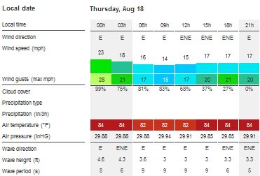
Skies will be partly cloudy. Winds will be easterly in direction at 10 mph to 25 mph. Seas will be moderate to rough at 1 to 4 ft or higher. Divers should exercise caution exiting and entering the boats, especially on the afternoon dives. The air temperatures will range from the high 70sºF to the mid to high 80s ºF or 26°C to 27ºC. Ocean water temperatures are 80°F to 82°F or 26ºC to 27ºC.
 | |
The Tropical Weather Outlook
For the North Atlantic...Caribbean Sea and the Gulf of Mexico:1. Gulf of Mexico - A surface ridge over the northern Gulf coast will shift south and stall from central Florida to the coast of Texas/Louisiana Sat through Mon. A recurring surface trough will support fresh winds over the E Bay of Campeche each night.
2. Caribbean Sea - A tropical wave over the E Caribbean will move W into the central Caribbean Thu and into the W Caribbean Fri and Sat. Another tropical wave over the central Atlantic will pass W of 55W today...the E Caribbean Fri...the central Caribbean Sat...and reach the W Caribbean Sun. Fresh to strong trades will persist across the central Caribbean through Mon night and reach near gale force along the NW coast of Colombia during late night and early morning hours through Fri night. Fresh to strong trades will affect the Gulf of Honduras tonight. The main effects of T.S. Fiona will remain E then NE of the area.
3. At 500 AM AST (0900 UTC), the center of Tropical Storm Fiona was located near latitude 16.2 North, longitude 40.3 West. Fiona is moving toward the west-northwest near 16 mph (26 km/h), and this general motion with some decrease in forward speed is expected during the next couple of days. Maximum sustained winds have increased to near 45 mph (75 km/h) with higher gusts. Some additional strengthening is possible today, followed by slow weakening by the weekend. Tropical-storm-force winds extend outward up to 35 miles (55 km) from the center. The estimated minimum central pressure is 1005 mb (29.68 inches).


All interests in the Bay Islands and on the North Coast of Honduras should monitor this system closely as it tracks westward toward us.
Currently this system does not pose a threat to the Bay Islands and north coast of Honduras. But all interests here should monitor this system as it moves west towards us.
4. Tropical Waves...
4a. A tropical wave is moving across the eastern Atlantic with axis extending from 20N26W to 12N24W, moving west at 15-20 kt. The wave coincides with 700 mb troughing that has emerged off the coast of west Africa. Isolated showers are observed along the wave axis south of 12N mostly enhanced by the presence of the Monsoon Trough.
4b. A tropical wave extends across the central Atlantic with axis from 17N51W to 08N53W, moving west at 20 kt. Global model data indicates mid-level energy is focused along the wave axis with plenty of dry Saharan air and dust surrounding the wave. With this, no significant convection is observed across the wave. However, across the southern portion of the wave where it meets the Monsoon Trough, scattered moderate convection prevails south of 11N.
4c. A tropical wave is moving across the eastern Caribbean with axis from 19N66W to 10N67W, moving west at 15-20 kt. The wave coincides with a westward surge of mid-level moisture as depicted by SSMI Total Precipitable Water imagery between 63W-68W. Despite this, no significant convection is observed at this time as Saharan dust and dry air prevails across the eastern Caribbean east of 65W inhibiting any activity.
4d. A tropical wave is moving southern Mexico and the EPAC with axis from 21N93W to 10N93W, moving west at 10-15 kt. Most of the energy associated with the wave is noted over the East Pacific region, however, scattered moderate convection is occurring across the southern portion of the Yucatan peninsula, Guatemala, and southern Mexico mainly south of 16N between 88W-97W.

Fig 3
- Recent changes in the Saharan Air Layer
The Tides: Moon and
Sun
low tide 2:24 am LT Sunrise – 5:33 am LT>76° East
high tide 8:09 am LT Sunset – 6:09 pm LT < 283° NW
low tide 2:27 pm LT Moon Rise – 06:32 pm LT<100° East
high tide 8:42 pm LT Moon Set – 05:40 am LT>258º West
high tide 8:09 am LT Sunset – 6:09 pm LT < 283° NW
low tide 2:27 pm LT Moon Rise – 06:32 pm LT<100° East
high tide 8:42 pm LT Moon Set – 05:40 am LT>258º West

Fig 4 - Moon
Day Light Hours: 12 hours, 36 minutes (-47s)
No comments:
Post a Comment