Wednesday, November 30, 2016

Mostly Sunny

The CoCoView Resort Weather Forecast
This weather forecast is intended for CoCoView Resort guests and applies only to the south side of Roatan
CoCoView is at 16.4°N Latitude x 86.4°W Longitude
in the
   NW Caribbean Sea

             CoCoView Resort, www.cocoviewresort.com , 800-510-8164


Wednesday, November 30, 2016
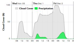
Skies will be partlymostly. Winds will be moderate and easterly in direction at 25 mph or less.  Seas will be moderate at2 ft. to 4ft. or more. The air temperatures will range from the high 70sºF to the mid to high 80s ºF or 26°C to 27ºC. Ocean water temperatures are 78°F to 80°F or 25ºC to 26ºC


The Tropical Weather Outlook
For the North Atlantic...Caribbean Sea and the Gulf of Mexico:
1. Tropical cyclone formation is not expected for the next 48 hours.
2. Gulf of Mexico - A cold front from SE Louisiana to Brownsville, TX will reach from the Florida Panhandle to S of Veracruz, Mexico tonight then stall and weaken Thu. N winds will briefly increase to gale force W of the front along the central and southern Mexico coast this afternoon and evening. The front will drift N Thu night and Fri...with fresh to strong E to SE winds developing in the north central Gulf Fri and Fri night. Another cold front will push into the NW Gulf Sun and extend from S Louisiana to Vercruz, Mexico Sun night.
3. Caribbean Sea - Widespread showers associated with a surface trough across the NE Caribbean will persist over the SE Caribbean today then weaken tonight as the trough moves W. The trough will shift slowly W across the basin Thu through Sat. Winds will freshen across tropical N Atantilc waters and E Caribbean Fri and Sat...with fresh SE winds developing in the NW Caribbean Sun ahead of a cold front moving through the Gulf of Mexico.
3a. ...From the Atlantic Ocean into the Caribbean Sea... Upper level cyclonic wind flow from the upper level trough of 24 hours ago covers the Caribbean Sea between 60W and 70W from coastal Venezuela to 20N. A NE-to-SW oriented surface trough is along 20N60W 16N64W 12N66W. Convective precipitation: widely scattered moderate to isolated strong from 10N to 20N between 54W and 67W. rainshowers are possible elsewhere from 10N to 20N between 50W and 70W.
3b. ...The Rest of the Caribbean Sea... Broad upper level anticyclonic wind flow spans the rest of the Caribbean Sea, from 70W westward, away from the eastern Caribbean Sea trough. Comparatively drier air in subsidence is apparent in water vapor imagery, elsewhere, to the west of the trough. Rainshowers are possible elsewhere, in areas of broken low level to middle level clouds, in the central sections of the Caribbean Sea, and in the NW corner of the area.
Fig 4 - Recent changes in the Saharan Air Layer
The Tides: Moon and Sun
low tide  2:35am LT                  Sunrise – 5:58 am LT>112° East
high tide 9:52 am LT                  Sunset – 5:14 pm LT < 248° NW
low tide 3:33 pm LT                   Moon Rise – 6:47 pm LT<109° East
high tide  8:27 pm LT                 Moon Set – 6:26 am LT>251º West  
                                                                                                                               

Fig 5 - Moon

Tuesday, November 29, 2016

Partly Sunny

The CoCoView Resort Weather Forecast
This weather forecast is intended for CoCoView Resort guests and applies only to the south side of Roatan
CoCoView is at 16.4°N Latitude x 86.4°W Longitude
in the
   NW Caribbean Sea

             CoCoView Resort, www.cocoviewresort.com , 800-510-8164


Tuesday, November 29, 2016
Skies will be partly sunny. Winds will be moderate and easterly in direction at 25 mph or less.  Seas will be moderate at2 ft. to 4ft. or more. The air temperatures will range from the high 70sºF to the mid to high 80s ºF or 26°C to 27ºC. Ocean water temperatures are 78°F to 80°F or 25ºC to 26ºC.


The Tropical Weather Outlook
For the North Atlantic...Caribbean Sea and the Gulf of Mexico:
1. Tropical cyclone formation is not expected for the next 48 hours.
2. Gulf of Mexico - Strong southerly winds will continue in the northern Gulf today ahead of a stalled cold front across coastal Texas. The front will move off the coast tonight and reach from the Florida Panhandle to S of Veracruz, Mexico Wed evening. N winds will briefly increase to gale force off the central Mexican coast Wed and shift S to Veracruz Wed night...then diminish early Thu. The front will stall and weaken along 26N Thu then drift N Thu night and Fri...with strong E winds near the front Fri and Sat.
3. Caribbean Sea - Showers and tstms associated with a surface trough from Venezuela across the Leeward Islands to a low centered near 19N60W are expected in the SE Caribbean... Windward Islands and tropical N Atlantic waters through tonight then gradually weaken Wed. The low and trough will meander over the region through tonight then move westward across the northern Caribbean Wed through Sat.
3a. ...The Rest of the Caribbean Sea... Broad upper level anticyclonic wind flow spans the rest of the Caribbean Sea, from 70W westward, away from the Atlantic Ocean- to-eastern Caribbean Sea trough. Comparatively drier air in subsidence is apparent in water vapor imagery, elsewhere, to the west of the Atlantic Ocean-to-eastern Caribbean Sea upper level trough. Convective precipitation: rainshowers are possible in areas of broken-to-overcast multilayered clouds, from 14N to 16N between 79W and 82W to the east of the Honduras/Nicaragua border, and from 16N to Haiti between 72W and 75W. The monsoon trough is along 10N, between 74W in Colombia, beyond NW Costa Rica, into the eastern Pacific Ocean. Convective precipitation: isolated moderate from 14N southward from 70W westward. 24-HOUR rainfall totals in inches for the period ending at 29/0000 UTC...according to the PAN AMERICAN TEMPERATURE AND PRECIPITATION TABLES...MIATPTPAN/SXCA01 KNHC...are 3.47 in in Guadeloupe, and 2.02 in Curacao.

Fig 4 - Recent changes in the Saharan Air Layer

The Tides: Moon and Sun
low tide  2:03 am LT                  Sunrise – 5:58 am LT>112° East
high tide 9:17 am LT                  Sunset – 5:14 pm LT < 248° NW
low tide 2:53 pm LT                   Moon Rise – 5:58 pm LT<107° East
high tide  7:54 pm LT                 Moon Set – 5:40 am LT>252º West 
                                                                                                                               

Fig 5 - Moon

Day Light Hours:   11 hours, 16 minutes (-25s)

Monday, November 28, 2016

Sunny

The CoCoView Resort Weather Forecast
This weather forecast is intended for CoCoView Resort guests and applies only to the south side of Roatan
CoCoView is at 16.4°N Latitude x 86.4°W Longitude
in the
   NW Caribbean Sea

             CoCoView Resort, www.cocoviewresort.com , 800-510-8164


Monday, November 28, 2016
Skies will be partly sunny. Winds will be light and easterly in direction at 15 mph or less.  Seas will be moderate at 1ft. to 3ft. or less.  There is a very slight chance of rain through Monday.  The air temperatures will range from the high 70sºF to the mid to high 80s ºF or 26°C to 27ºC. Ocean water temperatures are 80°F to 82°F or 26ºC to 27ºC.


The Tropical Weather Outlook
For the North Atlantic...Caribbean Sea and the Gulf of Mexico:
1. Tropical cyclone formation is not expected for the next 48 hours.
2. Gulf of Mexico - Strong to near gale force southerly winds across the NW waters this morning will spread E across the N central waters today ahead of a cold front that will stall over the NW coastal waters tonight. The front will retreat inland Tue...then return as strong cold front moving off NE Texas Tue night. The front will then reach from central Louisiana to NE Mexico Wed morning and from the Florida Panhandle to near Veracruz, Mexico Wed evening. N winds will briefly increase to gale force off the central Mexican coast Wed and shift S to Veracruz Wed afternoon and evening before diminishing Wed night through Thu.
3. Caribbean Sea - A trough extending from Puerto Rico to the ABC islands will shift E tonight...then stall Tue...before weakening and drifting W across the central Caribbean Wed and Thu. A cold front will stall N of the NW Caribbean late Thu.
3a. A middle to upper level shortwave trough is progressing eastward over the north-central Caribbean with axis extending SW to 12N77W. Dry and stable NW flow prevails W of the trough axis with fair skies and conditions across the NW Caribbean...Central America... and the SW Caribbean N of the Monsoon Trough axis along 10N. Scattered showers and isolated tstms are occurring S of 10N across portions of Panama and Costa Rica. E of the trough axis...middle to upper level moisture and cloudiness increase within W-SW flow aloft. A surface trough extends across Hispaniola from 20N70W to 12N70W providing focus for scattered showers and isolated strong tstms occurring N of 12N between 61W-69W. Otherwise...moderate SE winds prevail E of the trough axis and moderate to occasional fresh NE winds prevail W of the trough axis.
Fig 4 - Recent changes in the Saharan Air Layer
The Tides: Moon and Sun
low tide  1:35 am LT                  Sunrise – 5:57 am LT>112° East
high tide 8:42 am LT                  Sunset – 5:14 pm LT < 248° NW
low tide 2:17 pm LT                Moon Rise – 5:09 pm LT<105° East
high tide  7:26 pm LT                 Moon Set – 4:56 am LT>254º West 
Fig 5 - Moon

Day Light Hours: 11 hours, 16 minutes (-26s)

Sunday, November 27, 2016

Partly Cloudy

The CoCoView Resort Weather Forecast
This weather forecast is intended for CoCoView Resort guests and applies only to the south side of Roatan
CoCoView is at 16.4°N Latitude x 86.4°W Longitude
in the
   NW Caribbean Sea

             CoCoView Resort, www.cocoviewresort.com , 800-510-8164


Sunday, November 27, 2016
Skies will be partly sunny. Winds will be light and variable in direction at 15 mph or less.  Seas will be moderate at 1ft. to 3ft. or less.  There is a very slight chance of rain through Monday.  The air temperatures will range from the high 70sºF to the mid to high 80s ºF or 26°C to 27ºC. Ocean water temperatures are 80°F to 82°F or 26ºC to 27ºC.


The Tropical Weather Outlook
For the North Atlantic...Caribbean Sea and the Gulf of Mexico:
1. Tropical cyclone formation is not expected for the next 48 hours.
2. Gulf of Mexico - A weakening cold front will wash out across the SE Gulf waters tonight. A trough over the SW waters will move SW and inland Mexico tonight. Strong to near gale force southerly flow will develop across the NW waters tonight with these conditions spreading E across the N central waters on Mon ahead of cold front that will stall over the NW waters on Mon night. The front will move back inland early Tue...then return as a strong cold front moving off NE Texas on Tue night. The front will race E reaching the SE Gulf late Thu.
3. Caribbean Sea - A N to S orientated trough over the N central Caribbean will move E reaching from the Mona Passage to NW Venezuela tonight... reach from Puerto Rico to Aruba on Mon and stall from the Virgin Islands to the Curacao on Tue. The trough will move W on Wed night and Thu as a cold front stalls across the Yucatan Channel.
3a. The upper trough over the west Atlantic dips south over the northwest Caribbean with near zonal westerly flow aloft across the remainder of the basin. the monsoon trough has returned to the southwest Caribbean extending from Colombia near 10N75W through a 1009 mb low near 11N77W continuing across the Costa Rica/Nicaragua border and into the east Pacific region. Scattered showers and possible isolated thunderstorms are from 10N-15N between 74W-76W and from 10N-14N west of 83W to inland over Costa Rica and Nicaragua. Isolated showers dot the remainder of the area south of 15N between 63W-74W. A surface trough is expected to set up tonight and shift from the Mona Passage to northwest Venezuela coast on Monday then continue east to Puerto Rico to the ABC Islands on Tuesday.
Fig 4 - Recent changes in the Saharan Air Layer
The Tides: Moon and Sun
high tide 8:08 am LT                  Sunrise – 5:56 am LT>112° East
low tide 1:43 pm LT                  Sunset – 5:13 pm LT < 248° NW
high tide  6:59 pm LT                Moon Rise – 4:21 pm LT<102° East
low tide  1:35 am LT                 Moon Set – 4:14 am LT>257º West
                                                                                                                               

Fig 5 - Moon

Day Light Hours:  11 hours, 17 minutes (-27s)

Saturday, November 26, 2016

Partly Sunny

The CoCoView Resort Weather Forecast
This weather forecast is intended for CoCoView Resort guests and applies only to the south side of Roatan
CoCoView is at 16.4°N Latitude x 86.4°W Longitude
in the
   NW Caribbean Sea

             CoCoView Resort, www.cocoviewresort.com , 800-510-8164


Saturday, November 26, 2016
Skies will be partly sunny. Winds will be light and variable in direction at 15 mph or less.  Seas will be moderate at 1ft. to 3ft. or less.  There is a slight chance of rain through Monday.  The air temperatures will range from the high 70sºF to the mid to high 80s ºF or 26°C to 27ºC. Ocean water temperatures are 80°F to 82°F or 26ºC to 27ºC.


The Tropical Weather Outlook
For the North Atlantic...Caribbean Sea and the Gulf of Mexico:
1. Tropical cyclone formation is not expected for the next 48 hours.
2. Gulf of Mexico - A weak cold front from northern Florida to southern Texas will reach from central Florida to extreme S Texas tonight then weaken across the SE Gulf and Straits of Florida Sun. Strong southerly flow and high seas will develop across much of the western Gulf Sun night...and spread eastward to the central Gulf through Tue as a cold front approaches the Texas coast. The front will stall tue night...with southerly flow subsiding through Wed. Reinforcing cold air will push the front into the NW and central Gulf Wed and Wed night.
3. Caribbean Sea - Trade winds will diminish across the region through tonight as high pressure centerd near Bermuda shifts NE. A cold front will sweep across the SW N Atlantic tonight through Tue... reaching from 23N65W to SE Bahamas by Tue morning. Strong high pressure building behind the front will produce fresh to strong NE winds S of Cuba and Windward Passage Mon through Tue...spreading into SE waters Wed as the high shifts eastward.
3a. Subtle upper level troughing is noted on water vapor imagery over eastern Cuba and portions of the north-central Caribbean as upper level ridging persists over the NW Caribbean...Central America... along with much of the eastern Caribbean E of 72W. At the surface...fresh to occasional strong E-NE winds prevail between lower pressure across northern South America and a 1023 mb high centered across the SW North Atlc region near 31N65W. Most intense convection is occurring across the western Caribbean and portions of Central America with scattered showers and strong tstms generally S of 17N E of 70W to Central America across Nicaragua and Honduras. The pressure gradient is forecast to relax with the resulting trades expected to decrease late Saturday as the ridge to the north moves E-NE.
Fig 4 - Recent changes in the Saharan Air Layer
The Tides: Moon and Sun 
high tide 7:33 am LT                  Sunrise – 5:56 am LT>112° East
low tide 1:13 pm LT                  Sunset – 5:13 pm LT < 248° NW
high tide  6:34 pm LT                Moon Rise – 3:34 pm LT<98° East
low tide  1:08 am LT                 Moon Set – 3:34 am LT>260º West
                                                                                                                            
Fig 5 - Moon

Day Light Hours:  11 hours, 17 minutes (-28s)

Friday, November 25, 2016

Again Partly Sunny

The CoCoView Resort Weather Forecast
This weather forecast is intended for CoCoView Resort guests and applies only to the south side of Roatan
CoCoView is at 16.4°N Latitude x 86.4°W Longitude
in the
   NW Caribbean Sea

             CoCoView Resort, www.cocoviewresort.com , 800-510-8164


Friday, November 25, 2016
Skies will be partly sunny. Winds will be light and variable in direction at 20 mph or less.  Seas will be moderate at 1ft. to 3ft. or less.  There is an increasing chance of rain through the weekend.  The air temperatures will range from the high 70sºF to the mid to high 80s ºF or 26°C to 27ºC. Ocean water temperatures are 80°F to 82°F or 26ºC to 27ºC.


The Tropical Weather Outlook
For the North Atlantic...Caribbean Sea and the Gulf of Mexico:1. Tropical cyclone formation is not expected for the next 48 hours.
2. Gulf of Mexico - A nearly stationary front from the W Florida Panhandle to near Corpus Christi, TX will weaken while a reinforcing front moves into the northern Gulf this afternoon and tonight...merging with the old front...and then reaching from N Florida to S Texas early Sat. This front will then weaken across the S Gulf Sun and Sun night. strong southerly flow and high seas will develop across the W and N central Gulf late Sun through Tue.
3. Caribbean Sea - Weak troughing over the SW Caribbean will persist the next few days. High pressure n of the area will maintain fresh to strong NE winds over much of the NW and N central Caribbean through tonight before subsiding. A new cold front will sweep SE across the SW N Atlantic Sun through Tue with building ridge behind front to produce freshening winds over much of the N and central Caribbean including Atlantic passages Mon through Tue night.
4. ...SPECIAL FEATURES...
Tropical Storm Otto is centered near 10.5N 86.9W at 25/0900 UTC or about 120 nm west-northwest of Cabo Blanco, Costa Rica moving west at 12 kt. Estimated minimum central pressure is 998 mb. Maximum sustained wind speed is 50 kt with gusts to 60 kt. Scattered heavy showers and isolated tstms are from 10N-13N between 85W and 89W. The center of Otto will continue to move away from the coast of Central America today. Heavy rains associated with Otto will continue to affect portions of northern Costa Rica and southern Nicaragua into early this morning. These rains are expected to move offshore of Costa Rica and Nicaragua into the eastern Pacific later today. Earlier heavy rains and the potential additional rainfall will continue to pose the threat of life-threatening floods and mudslides across these regions. Swells generated by Otto are likely to cause life-threatening surf and rip current conditions over the next several days along the coasts of Panama, Costa Rica, and Nicaragua. Otto is no longer in the Atlantic Basin.


Fig 4 - Recent changes in the Saharan Air Layer
The Tides: Moon and Sun
high tide 6:59 am LT                  Sunrise – 5:55 am LT>111° East
low tide 12:44 pm LT                 Sunset – 5:13 pm LT < 248° NW
high tide  6:07 pm LT                Moon Rise – 2:47 pm LT<94° East
low tide  12:44 am LT               Moon Set – 2:55 am LT>264º West  
                                                                                                                         
Fig 5 - Moon

Day Light Hours: 11 hours, 17 minutes (-29s)

Thursday, November 24, 2016

Partly Sunny

The CoCoView Resort Weather Forecast
This weather forecast is intended for CoCoView Resort guests and applies only to the south side of Roatan
CoCoView is at 16.4°N Latitude x 86.4°W Longitude
in the
   NW Caribbean Sea

             CoCoView Resort, www.cocoviewresort.com , 800-510-8164


Thursday, November 24, 2016
Skies will be partly sunny. Winds will be light and variable in direction at 20 mph or less.  Seas will be moderate at 1ft. to 3ft. or less.  There is an increasing chance of rain through the weekend.  The air temperatures will range from the high 70sºF to the mid to high 80s ºF or 26°C to 27ºC. Ocean water temperatures are 80°F to 82°F or 26ºC to 27ºC.


The Tropical Weather Outlook
For the North Atlantic...Caribbean Sea and the Gulf of Mexico:
1.HURRICANE OTTO DISCUSSION NUMBER 15 NWS NATIONAL HURRICANE CENTER MIAMI FL AL162016 1000 AM EST THU NOV 24 2016
An Air Force Reserve Hurricane Hunter plane penetrated the eye of Otto around 1200 UTC this morning and indicated that the hurricane was intensifying. The estimated central pressure dropped to 976 mb and the flight-level wind at 700 mb peaked at 108 kt while the SFMR winds reached 90 kt. Since that time, satellite imagery showed that the hurricane cloud pattern has become better organized with a distinct eye in both convectional and microwave imagery, and the Data-T numbers reached 5.5 on the Dvorak scale. On this basis, the initial intensity has been set at 95 kt. There is an opportunity for some additional strengthening before Otto makes landfall during the next several hours. However, weakening should begin after the eye moves farther inland across Central America. Otto is expected to emerge over the eastern Pacific in about 12 to 24 h as a tropical storm. Otto should continue to weaken as it moves over the eastern pacific given that strong shear is forecast to prevail in that region, and the cyclone should become a remnant low by the end of the forecast period. The NHC intensity forecast is very similar to the previous one. Satellite and reconnaissance fixes indicate that Otto is moving toward the west or 270 degrees at 8 kt. The hurricane is trapped within easterly flow associated with a strong high pressure to the north, and since this high is forecast to persist, the hurricane should continue on a general west to west-southwest track for the next 3 days. After that time, a much weaker Otto should turn to the west-northwest around the western edge of the high. The track guidance is very consistent with this scenario and there is no need to deviate from the previous NHC forecast. The forecast track continues to be very close to the multi-model consensus.
NHC thanks the crew of the Air Force Reserve Hurricane Hunters for flying and providing valuable data on Thanksgiving Day.
2. Gulf of Mexico - A nearly stationary front from SE Louisiana to S Texas will weaken through tonight. A cold front moving into the northern Gulf Fri will extend from northern Florida to south Texas early Sat...and weaken across the southern Gulf Sun. Strong southerly flow will develop in the western and central Gulf Mon...with building seas.
3. Caribbean Sea - Hurricane Otto near 11.0N 83.4W 975 mb at 10 am EST moving W at 8 kt. maximum sustained winds 95 kt gusts 115 kt. Otto is forecast to make landfall along the coast of S Nicaragua today then weaken to a tropical storm. Seas in the SW Caribbean will rapidly subside after landfall. High pressure N of the area will maintain fresh to strong NE winds over much of the E and central Caribbean through Fri night. Another high building N of the area will increase winds over the N Caribbean Mon. All interests in the Bay Islands and on the North Coast of Honduras should monitor this system closely as it tracks westward. Currently this system does not pose a threat to the Bay Islands and north coast of Honduras. But all interests here should monitor this system as it moves west.
Fig 4 - Recent changes in the Saharan Air Layer
The Tides: Moon and Sun
high tide 6:23 am LT                  Sunrise – 5:55 am LT>111° East
low tide 12:13 pm LT                 Sunset – 5:13 pm LT < 249° NW
high tide  5:37 pm LT                Moon Rise – 1:59 pm LT<90° East
low tide  12:21 am LT               Moon Set – 2:17 am LT>268º West  
                                                                                                                               

Fig 5 - Moon

Day Light Hours: 11 hours, 18 minutes (-30s)

Wednesday, November 23, 2016

Mostly Sunny

The CoCoView Resort Weather Forecast
This weather forecast is intended for CoCoView Resort guests and applies only to the south side of Roatan
CoCoView is at 16.4°N Latitude x 86.4°W Longitude
in the
   NW Caribbean Sea

             CoCoView Resort, www.cocoviewresort.com , 800-510-8164


Wednesday, November 23, 2016
Skies will be mostly sunny. Winds will be light and variable in direction at 10 mph or less.  Seas will be moderate at 1ft. to 3ft. or less.  There is an increasing chance of rain through the weekend.  The air temperatures will range from the high 70sºF to the mid to high 80s ºF or 26°C to 27ºC. Ocean water temperatures are 80°F to 82°F or 26ºC to 27ºC.


The Tropical Weather Outlook
For the North Atlantic...Caribbean Sea and the Gulf of Mexico:
1. TROPICAL STORM OTTO DISCUSSION NUMBER 11 NWS NATIONAL HURRICANE CENTER MIAMI FL AL162016 1000 AM EST WED NOV 23 2016
Otto has lost some organization since yesterday. The last Air Force Reserve reconnaissance mission reported that the eyewall has dissipated, along with a 6-mb rise in pressure. Still, the maximum 700-mb flight-level winds were 68 kt, with SFMR winds of about 50 kt. The initial intensity is conservatively reduced to 60 kt for this advisory. It appears that the southeasterly shear has been a little stronger than forecast yesterday, which has allowed some drier air to mix into the cyclone. This is evident in the inner-core data from the Air Force mission, which showed rather low dewpoints at 700 mb. The global models are suggesting the shear will decrease before landfall, and Otto should be moving over warmer waters later today that have not be subjected to any storm-forced upwelling. These factors suggest some restrengthening is possible overnight and Thursday, which is consistent with the bulk of the guidance models. Stronger shear over the eastern Pacific is expected to cause gradual weakening of Otto in that basin, with remnant low status likely by day 5.
The official intensity forecast has been reduced somewhat from the last one but still calls for Otto to be a hurricane at landfall. Aircraft fixes show that Otto continues to move toward the west-northwest at 4 kt. A building mid-level ridge to the north of Otto should cause the tropical cyclone to turn westward and accelerate tonight. Late in the period, a motion south of due west is indicated as the mid-level ridge amplifies over the eastern Pacific. Model guidance is tightly clustered on this solution, and the latest official forecast is very close to the previous one.
2. Gulf of Mexico - A cold front will move into the NW Gulf tonight then weaken from SE Louisiana to south Texas Thu morning. A second cold front will move into the northern Gulf Fri. The front will extend from northern Florida to south Texas early Sat and from south Florida to the central Gulf early Sun.
3. Caribbean Sea - Tropical storm Otto near 11.1N 80.7W 994 mb at 1500 utc moving WNW at 4 kt. Maximum sustained winds 60 kt gusts 75 kt. Otto is forecast to re intensify to hurricane strength early Thursday before it makes landfall near southern Nicaragua. High pressure N of the Caribbean will support fresh to strong NE winds over a broad area of the central and W Caribbean N of 15N from Hispaniola to Honduras through Fri night.
All interests in the Bay Islands and on the North Coast of Honduras should monitor this system closely as it tracks westward. Currently this system does not pose a threat to the Bay Islands and north coast of Honduras. But all interests here should monitor this system as it moves west..


Fig 4 - Recent changes in the Saharan Air Layer
The Tides: Moon and Sun
high tide 5:42 am LT                  Sunrise – 5:54 am LT>111° East
low tide 11:36 am LT                 Sunset – 5:13 pm LT < 249° NW
high tide  5:04 pm LT                Moon Rise – 1:11 pm LT<86° East
low tide  11:54 pm LT               Moon Set – 1:39 am LT>272º West
                                                                                                                               

Fig 5 - Moon

Day Light Hours:  11 hours, 18 minutes (-30s)

Tuesday, November 22, 2016

Skies will be Mostly Sunny.

The CoCoView Resort Weather Forecast
This weather forecast is intended for CoCoView Resort guests and applies only to the south side of Roatan
CoCoView is at 16.4°N Latitude x 86.4°W Longitude
in the
   NW Caribbean Sea

             CoCoView Resort, www.cocoviewresort.com , 800-510-8164


Tuesday, November 22, 2016
Skies will be mostly sunny. Winds will be moderate and mainly NNE to NE in direction at 15 mph or less.  Seas will be moderate at 2ft. to 4ft. or less.  There is a extremely slight chance of rain today.  The air temperatures will range from the high 70sºF to the mid to high 80s ºF or 26°C to 27ºC. Ocean water temperatures are 80°F to 82°F or 26ºC to 27ºC.


The Tropical Weather Outlook
For the North Atlantic...Caribbean Sea and the Gulf of Mexico:1. Tropical Storm Otto is nearly stationary near 10.4N 79.2W 986 mb at 1500 utc. Maximum sustained winds 60 kt gusts 75 kt. Otto is expected to intensify to hurricane by tonight and drift w toward southern Nicaragua through Thu. High pressure building N of the Caribbean will support fresh to strong NE winds over a large area N of Otto from S of Hispaniola to Costa Rica through Fri night.
All interests in the Bay Islands and on the North Coast of Honduras should monitor this system closely as it tracks westward. Currently this system does not pose a threat to the Bay Islands and north coast of Honduras. But all interests here should monitor this system as it moves west..2. Gulf of Mexico - Winds and seas will diminish today as high pressure N of the area shifts eastward. Moderate to fresh return flow will develop W of 90W through Wed. A cold front will push into the northern Gulf Wed night...stall there...then lift N of the area late Thu. Another cold front will approach the N central Gulf by late Fri.
3. ...Special Features... Tropical Storm Otto is centered near 10.5N 79.1W at 22/1200 UTC or about 195 nm SE of San Andres Island and about 290 nm ESE of Bluefields Nicaragua. Otto is currently nearly stationary. Estimated minimum central pressure is 986 mb. Maximum sustained wind speed is 60 kt with gusts to 75 kt. Numerous strong convection is within 75 nm from the center of Otto. Scattered moderate convection is elsewhere from 08N-16N between 77W-83W. See latest NHC Intermediate Public Advisory under AWIPS/WMO headers MIATCPAT1/WTNT31 KNHC and the full Forecast/Advisory under AWIPS/WMO headers MIATCMAT1/WTNT21 KNHC for more details.

Fig 4 - Recent changes in the Saharan Air Layer
The Tides: Moon and Sun
high tide 4:52 am LT                  Sunrise – 5:54 am LT>111° East
low tide 10:51 am LT                 Sunset – 5:13 pm LT < 249° NW
high tide  4:26 pm LT                Moon Rise – 12:22 pm LT<82° East
low tide  11:20 pm LT               Moon Set – 12:59 am LT>276º West
                                                                                                                            
Fig 5 - Moon

Monday, November 21, 2016

Mostly Sunny

The CoCoView Resort Weather Forecast
This weather forecast is intended for CoCoView Resort guests and applies only to the south side of Roatan
CoCoView is at 16.4°N Latitude x 86.4°W Longitude
in the
   NW Caribbean Sea

             CoCoView Resort, www.cocoviewresort.com , 800-510-8164


Monday, November 21, 2016
Skies will be mostly sunny. Winds will be moderate and mainly NNE in direction at 10 mph or less.  Seas will be moderate at 2ft. to 4ft. Or less.  There is a extremely slight chance of rain today.  The air temperatures will range from the high 70sºF to the mid to high 80s ºF or 26°C to 27ºC. Ocean water temperatures are 80°F to 82°F or 26ºC to 27ºC.


The Tropical Weather Outlook
For the North Atlantic...Caribbean Sea and the Gulf of Mexico:1. TROPICAL DEPRESSION SIXTEEN DISCUSSION NUMBER 2 NWS NATIONAL HURRICANE CENTER MIAMI FL AL162016 1000 AM EST MON NOV 21 2016 The cloud pattern of the tropical cyclone is gradually becoming better organized, with some banding features over the northern and western portions of the circulation and small bursts of deep convection near or over the estimated center. The current intensity is held at 30 kt in agreement with a Dvorak estimate from TAFB, pending an Air Force reconnaissance mission into the cyclone this afternoon. There is moderate south-southeasterly shear over the depression, and this should allow for only slow strengthening over the next day or two. In 72 hours or so, some relaxation of the shear is forecast with an upper-level anticyclone developing over the tropical cyclone, and the system is predicted to become a hurricane before landfall. The official intensity forecast is the same as the previous one, and is close to the latest SHIPS model guidance. Satellite-derived center fixes indicate little motion since late yesterday. The depression is currently located near a col in the mid-level flow, so steering currents are very weak at this time. Global model guidance shows a high developing to the north of the system in a few days, so a generally westward track is forecast. The official track forecast is mainly a blend of the ECMWF and GFS tracks, with the former model being faster and farther south and the latter being slower and farther north. The new official forecast is very similar to the previous NHC forecast track.
2. Gulf of Mexico - Winds and seas will diminish today as high pressure N of the area shifts eastward. Moderate to fresh return flow will develop W of 90W Tue and Wed. A cold front will push into the northern Gulf Wed night...stall and weaken thu then lift N of the area late Thu. A weak cold front will approach the N central Gulf by late Fri.
3. Caribbean Sea - Tropical Depression Sixteen remains stationary near 11.5N 79.3W 1002 mb at 1500 utc. maximum sustained winds 30 kt gusts 40 kt. It is expected to drift westward toward Nicaragua and intensify through Thu. A cold front across the NW Caribbean will enhance fresh to strong NE winds over a large area north of the depression from the Windward Passage to Costa Rica through Fri. 
Currently this system does not pose a threat to the Bay Islands and north coast of Honduras. But all interests here should monitor this system as it moves west towards us. All interests in the Bay Islands and on the North Coast of Honduras should monitor this system closely as it tracks westward toward us.
Fig 4 - Recent changes in the Saharan Air Layer
The Tides: Moon and Sun 
high tide 3:48 am LT                Sunrise – 5:53 am LT>111° East
low tide 9:54 am LT                  Sunset – 5:13 pm LT < 249° NW
high tide  3:42 pm LT                Moon Rise – 12:25 pm LT<78° East
low tide  10:56 pm LT               Moon Set – 12:18 am LT>280º West   
                                                                                                                                
Fig 5 - Moon

Day Light Hours:  11 hours, 19 minutes (-32s)