The
CoCoView Resort Weather Forecast
This weather
forecast is intended for CoCoView Resort guests and applies only to
the south side of Roatan
CoCoView is at 16.4°N
Latitude x 86.4°W Longitude
in the
NW Caribbean Sea
in the
NW Caribbean Sea
CoCoView Resort, www.cocoviewresort.com
, 800-510-8164
Skies will be mostly sunny. Winds will be mostly easterlyin direction and light at 0 mph to 15 mph. Seas will be moderate at 1 ft. to 4 ft. or less. The air temperatures will range from the low 70sºF to the mid 80s ºF or 22°C to 24ºC. Ocean water temperatures are 79°F to 81°F or 26ºC to 27ºC.

 |
 |
The Tropical Weather Outlook
For the North Atlantic...Caribbean Sea and the Gulf of Mexico:
1. There are no tropical cyclones in the Atlantic at this time.
The Atlantic hurricane season runs from June 1st through November 30th.
2. Gulf of Mexico - 18 hour forecast cold front from 30N92W to 27N97W. NW of front N winds 20 to 25 kt. Seas less than 8 ft.
24 hour forecast cold front from 30N89W to 26N97W. NW of front N winds 20 to 25 kt. Seas less than 8 ft.
48 hour forecast cold front from 29N83W to 21N90W. Winds 20 kt or less. Seas less than 8 ft.
3. Caribbean Sea - Remainder of area winds 20 kt or less. Seas less than 8 ft.

Fig 4
- Recent changes in the Saharan Air Layer
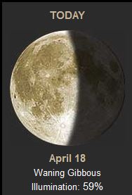
The Tides: Moon and
Sun
high tide 5:41 pm LT Sunrise – 5:27 am LT>77° East
low tide 11:54 am LT Sunset – 6:03 pm LT < 283° West
high tide 6:04 pm LT Moon Rise –02:31 am LT<100° East
low tide 12:09 am LT Moon Set – 02:36 pm LT>262º West
high tide 5:41 pm LT Sunrise – 5:27 am LT>77° East
low tide 11:54 am LT Sunset – 6:03 pm LT < 283° West
high tide 6:04 pm LT Moon Rise –02:31 am LT<100° East
low tide 12:09 am LT Moon Set – 02:36 pm LT>262º West

Fig 5 - Moon