The
CoCoView Resort Weather Forecast
This weather
forecast is intended for CoCoView Resort guests and applies only to
the south side of Roatan
CoCoView is at 16.4°N
Latitude x 86.4°W Longitude
in the
NW Caribbean Sea
in the
NW Caribbean Sea
CoCoView Resort, www.cocoviewresort.com
, 800-510-8164
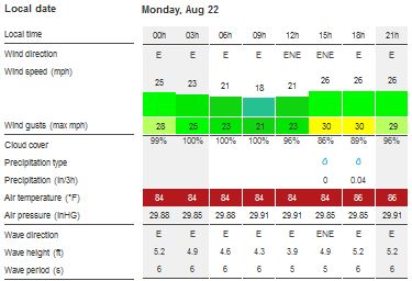
Skies will be mostly cloudy. Winds will be easterly in direction at 10 mph to 30 mph. Seas will be moderate to rough at 2 to 4 ft or higher. Divers should exercise caution exiting and entering the boats, especially on the afternoon dives. The air temperatures will range from the high 70sºF to the mid to high 80s ºF or 26°C to 27ºC. Ocean water temperatures are 80°F to 82°F or 26ºC to 27ºC.

The Tropical Weather Outlook
For the North Atlantic...Caribbean Sea and the Gulf of Mexico:
1. Gulf of Mexico - A recurring surface trough will support fresh to strong NE to E winds along the NW coast of the Yucatan Peninsula and across the E Bay of Campeche tonight...with fresh conditions expected to develop each evening through Wed evening. A surface high over the E central Gulf will shift NW reaching near the Mississippi Delta on Tue...then shift N of the area on Wed leaving a NE to SW ridge across the northern Gulf waters on Thu with the ridge weakening on Fri.
2. Caribbean Sea - A tropical wave along 78W will move through the W Caribbean through Tue night. Strong trades across the S central Caribbean will diminish beginning Wed night. A tropical wave is along 48W with a low along wave near 15N48W. This system will reach along 55W late tonight and pass W NW through the tropical waters E of the Lesser Antilles on Tue into early Wed when it will reach the Virgin Island area. Conditions may become favorable for tropical cyclone development in 3-5 days.
3. Tropical depression Fiona is centered near 24.4N 58.4W at 22/0900 UTC or about 456 nm northeast of the northern Leeward Islands, moving west-northwest at 16 kt. Estimated minimum central pressure is 1008 mb. Maximum sustained wind speed is 30 kt with gusts to 40 kt. Scattered heavy showers and isolated tstms are from 22N to 26N between 54W and 58W.
4. ...TROPICAL WAVES...
4a. A tropical wave is in the east Atlantic extending from 06N-16N with axis near 24W, moving west at 15 kt within the last 24 hours. The wave is associated with a 1008 mb low that is centered near 11N24W. Abundant moisture in the wave environment, favorable deep layer wind shear and middle to upper level diffluence favor numerous heavy showers and isolated tstms from 09N to 15N between 25W and 28W. Scattered heavy showers are from 05N to 09N between 22W and 37W. Environmental conditions are conducive for development, and a tropical depression is likely to form later today while the system moves westward to west-northwestward over the eastern tropical Atlantic Ocean.
4b. Tropical wave is in the central Atlantic extending from 08N-19N with axis near 47W, moving W at 15-20 kt within the last 24 hours. There is a 1010 mb low near 14N47W associated with the wave. Saharan dry air and dust in the wave environment limit the convection to scattered showers and tstms from 14N to 18N between 44W and 52W. Dry air near this system is expected to inhibit significant development during the next few days while the disturbance moves westward to west-northwestward. Environmental conditions could become more conducive for development late this week when the system is expected to move near Hispaniola and the southeastern and central Bahamas.
4c. Tropical wave is in the western Caribbean extending from 10N to 21N with axis near 80W, moving west at 15 kt within the last 24 hours. CIRA LPW imagery from the surface to 850 mb show large patches of dry air in the wave environment mainly east of the wave axis. Water vapor imagery continue to show strong dry air subsidence across this region of the Caribbean. This results in a tropical wave devoid of convection at this time.

Fig 3
- Recent changes in the Saharan Air Layer
The Tides: Moon and
Sun
low tide 5:40 am LT Sunrise – 5:33 am LT>78° East
high tide 12:32 pm LT Sunset – 6:06 pm LT < 282° NW
low tide 6:17 pm LT Moon Rise – 9:42 pm LT<81° East
high tide 11:57 pm LT Moon Set – 9:33 am LT>277º West
high tide 12:32 pm LT Sunset – 6:06 pm LT < 282° NW
low tide 6:17 pm LT Moon Rise – 9:42 pm LT<81° East
high tide 11:57 pm LT Moon Set – 9:33 am LT>277º West

Fig 4 - Moon
Day Light Hours: 12 hours, 33 minutes (-48s)
No comments:
Post a Comment