Tuesday, December 31, 2013

New Year's Eve 2013

The CoCoView Resort Weather Forecast
This weather forecast is intended for CoCoView Resort guests and applies only to the south side of Roatan 

CoCoView is at 16.4°N Latitude x 86.4°W Longitude 
in the
   NW Caribbean Sea

             CoCoView Resort, www.cocoviewresort.com , 800-510-8164

How to use this page:
The title of each of the figures below is linked to the page where the information originates.
Since I write and post early in the day and generally do not update the page until the next morning; by clicking on the link, it allows you, the viewer, to get the latest information.
This is not only convenient but allows you to track weather events such as cold fronts and hurricanes from a single web page.
In addition, in the right column is a very useful widget. It is a trip planner...yesteryear's weather at a glance.This widget lets you check historic weather for your trip dates.

Tuesday, Dec. 31, 2013
Again, today, skies will be partly cloudy. Winds will be light and ESE in direction at 10 to 12 mph during the day; increasing to 12 to 15 mph from the ENE this afternoon and evening. Seas will be choppy at 2 to 4 feet. Winds and seas are forecast to remain at these strengths or slightly lower for the next 7 to 10 days. Divers should exercise caution exiting and entering the boats, especially on the afternoon dives.
There is a continuing chance for scattered, intermittent showers as cool, high pressure air continues to push in from the north.
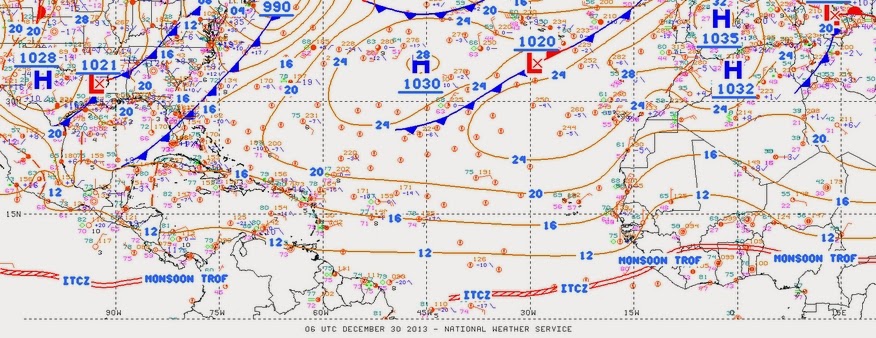
This morning, satellite imagery shows that a cold front is stalled from the Florida Keys to the W Bay of Campeche, Mexico. A second cold front will move into the NW Gulf of Mexico late Wednesday into early Thursday and rapidly move across the Gulf waters and SE of the area late Friday.
The air temperatures will range from the high 70s (ºF) to the mid 80s (ºF) or 24ºC to 26ºC.
Ocean water temperatures are 79°F to 82°F or 25ºC to 26ºC. Visibility is 20 to 80 ft.

The SAL (Saharan Air Layer) has changed in area and in density. See Figs. 9 and 9a below.


Fig 9a - Recent changes in the Saharan Air Layer


The Tides: Moon and Sun
low tide 1:24 am LT                      Moon Rise – 5:11 am LT
high tide 8:12 am LT                     Moon Set – 4:49 pm LT
low tide 2:02 pm LT                     Sunrise – 6:14 am LT
high tide 7:35 pm LT                    Sunset – 5:26 pm LT


For text or mobile version go to: http://www.cocoviewresort.com/weather.php


Monday, December 30, 2013

Monday 131230....Internet Uploading Still SLOWWWWWWWWWWWWW

The CoCoView Resort Weather Forecast
This weather forecast is intended for CoCoView Resort guests and applies only to the south side of Roatan 

CoCoView is at 16.4°N Latitude x 86.4°W Longitude 
in the
   NW Caribbean Sea

             CoCoView Resort, www.cocoviewresort.com , 800-510-8164

How to use this page:
The title of each of the figures below is linked to the page where the information originates.
Since I write and post early in the day and generally do not update the page until the next morning; by clicking on the link, it allows you, the viewer, to get the latest information.
This is not only convenient but allows you to track weather events such as cold fronts and hurricanes from a single web page.
In addition, in the right column is a very useful widget. It is a trip planner...yesteryear's weather at a glance.This widget lets you check historic weather for your trip dates.

Monday, Dec. 30, 2013
Again, today, skies will be partly cloudy. Winds will be light and variable in direction at 10 mph or less. Seas will be moderate to calm at 1 to 3 feet. Winds and seas are forecast to remain at these strengths or slightly higher for the next 7 to 10 days.. There is a chance for scattered, intermittent showers as cool, high pressure air continues to push in from the north.
This morning, satellite imagery shows that the cold front is stalled from the Florida Keys to the Yucatan Straits. A second, strong cold front is moving off the Texas coast and will merge with the stalled front later today. This system is forecast to move NE on Wednesday. A third cold front will enter the Gulf of Mexico early Thursday.
The air temperatures will range from the high 70s (ºF) to the mid 80s (ºF) or 24ºC to 26ºC.
Ocean water temperatures are 79°F to 82°F or 25ºC to 26ºC. Visibility is 20 to 80 ft.
The SAL (Saharan Air Layer) has increased in area and decreased in density. See Figs. 9 and 9a below.


Fig 9a - Recent changes in the Saharan Air Layer


The Tides: Moon and Sun
low tide 12:38 am LT                    Moon Rise – 4:09 am LT
high tide 7:31 am LT                     Moon Set – 3:48 pm LT
low tide 1:16 pm LT                      Sunrise – 6:14 am LT
high tide 6:41 pm LT                     Sunset – 5:26 pm LT


For text or mobile version go to: http://www.cocoviewresort.com/weather.php


Sunday, December 29, 2013

The Internet Connection is Still Poor!

The CoCoView Resort Weather Forecast
This weather forecast is intended for CoCoView Resort guests and applies only to the south side of Roatan 

CoCoView is at 16.4°N Latitude x 86.4°W Longitude 
in the
   NW Caribbean Sea

             CoCoView Resort, www.cocoviewresort.com , 800-510-8164

How to use this page:
The title of each of the figures below is linked to the page where the information originates.
Since I write and post early in the day and generally do not update the page until the next morning; by clicking on the link, it allows you, the viewer, to get the latest information.
This is not only convenient but allows you to track weather events such as cold fronts and hurricanes from a single web page.
In addition, in the right column is a very useful widget. It is a trip planner...yesteryear's weather at a glance.This widget lets you check historic weather for your trip dates.

Sunday, Dec. 29, 2013
Again, today, skies will be partly cloudy. Winds will be light and variable in direction at 10 mph or less. Seas will be moderate to calm at 1 to 3 feet. Winds and seas are forecast to remain at these strengths or slightly higher through most of this week. There is a chance for scattered, intermittent showers as cool, high pressure air continues to push in from the north.
This morning, satellite imagery shows that a cold front stretches from the Florida Panhandle to the Yucatan Straits and the Belize/Mexican border. It is forecast to move NE today and merge with a second cold front on Monday and Tuesday. This system is forecast to dissipate on Wednesday.
The air temperatures will range from the high 70s (ºF) to the mid 80s (ºF) or 24ºC to 26ºC.
Ocean water temperatures are 79°F to 82°F or 25ºC to 26ºC. Visibility is 20 to 80 ft.

The SAL (Saharan Air Layer) has changed in area and in density. See Figs. 9 and 9a below.


Fig 4 - Today's Tropical Surface Analysis
http://www.intellicast.com/Storm/Hurricane/AtlanticAnalysis.aspx
Not Available Today


Fig 9a - Recent changes in the Saharan Air Layer


The Tides: Moon and Sun
high tide 6:50 am LT                       Moon Rise – 3:08 am LT
low tide 12:31 am LT                      Moon Set – 2:52 pm LT
high tide 5:51 pm LT                      Sunrise – 6:14 am LT
low tide 12:38 am LT                     Sunset – 5:25 pm LT


For text or mobile version go to: http://www.cocoviewresort.com/weather.php