The
CoCoView Resort Weather Forecast
This weather
forecast is intended for CoCoView Resort guests and applies only to
the south side of Roatan
CoCoView is at 16.4°N
Latitude x 86.4°W Longitude
in the
NW Caribbean Sea
in the
NW Caribbean Sea
CoCoView Resort, www.cocoviewresort.com
, 800-510-8164
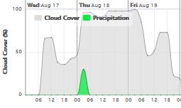
Skies will be partly cloudy. Winds will be easterly in direction at 10 mph to 30 mph. Seas will be moderate to rough at 1 to 4 ft or higher. Divers should exercise caution exiting and entering the boats, especially on the afternoon dives. The air temperatures will range from the high 70sºF to the mid to high 80s ºF or 26°C to 27ºC. Ocean water temperatures are 80°F to 82°F or 26ºC to 27ºC.

 | |
The Tropical Weather Outlook
For the North Atlantic...Caribbean Sea and the Gulf of Mexico:1. Gulf of Mexico - A ridge will linger along the N Gulf coast through Thu...then shift southward and extend from central FL to NE Texas Fri through Sun night. A thermal trough will support fresh winds over the E Bay of Campeche each night.
2. Caribbean Sea - A tropical wave over the W Caribbean will move W into Central America today. Another tropical wave in the tropical N Atlantic will cross the Windwards into the NE Caribbean today. Fresh to strong trades will persist across the central Caribbean through Sun night and near gale force along the NW coast of Colombia during late night and early morning hours through Fri. Fresh to strong trades will affect the Gulf of Honduras tonight.
3. Tropical Depression Six moving northwestward over the central tropical Atlantic...
Location...13.2N 35.2W about 775 mi...1245 km WSW of the Cabo Verde Islands maximum sustained winds...35 mph present movement...NW or 305 degrees at 15 mph.

All interests in the Bay Islands and on the North Coast of Honduras should monitor this system closely as it tracks westward toward us.
Currently this system does not pose a threat to the Bay Islands and north coast of Honduras. But all interests here should monitor this system as it moves west towards us.
4. Tropical Waves...
4a. A tropical wave is moving across the eastern Atlantic with axis from 17N36W to 10N38W, moving west at around 10-15 kt. This wave was related to the now T.D. Six. The convection observed in the vicinity of the wave is related to the T.D., which extends from 11N-16N and east of 37W.
4b. A tropical wave extends across the central Atlantic with axis from 25N59W to 16N61N, moving west at 10-15 kt. The wave coincides with a westward surge of abundant moisture as depicted by SSMI Total Precipitable Water imagery from 19N-29N between 57W-63W. Isolated showers are observed from 20N-26N between 59W-62W.
4c. A tropical wave is moving across the W Caribbean with axis extending from 20N85W to 11N84W, moving west at about 20 kt. The wave coincides with a maximum in potential vorticity over the SW Caribbean mainly south of 20N between 77W-85W. Scattered moderate convection prevails where the wave meets the Monsoon Trough affecting Nicaragua, Costa Rica and their adjacent waters mainly south of 22N and west of 81W.

Fig 3
- Recent changes in the Saharan Air Layer
The Tides: Moon and
Sun
low tide 1:47 am LT Sunrise – 5:32 am LT>76° East
high tide 7:26 am LT Sunset – 6:10 pm LT < 284° NW
low tide 1:47 pm LT Moon Rise – 05:43 pm LT<103° East
high tide 8:12 pm LT Moon Set – 04:43 am LT>255º West
high tide 7:26 am LT Sunset – 6:10 pm LT < 284° NW
low tide 1:47 pm LT Moon Rise – 05:43 pm LT<103° East
high tide 8:12 pm LT Moon Set – 04:43 am LT>255º West

Fig 4 - Moon
No comments:
Post a Comment