The
CoCoView Resort Weather Forecast
This weather
forecast is intended for CoCoView Resort guests and applies only to
the south side of Roatan
CoCoView is at 16.4°N
Latitude x 86.4°W Longitude
in the
NW Caribbean Sea
in the
NW Caribbean Sea
CoCoView Resort, www.cocoviewresort.com
, 800-510-8164
How to use this page:
The title of each of the
figures below is linked to the page where the information originates.
Since I write and post early
in the day and generally do not update the page until the next
morning; by clicking on the link, it allows you, the viewer, to get
the latest information.
This is not only convenient
but allows you to track weather events such as cold fronts and
hurricanes from a single web page.
In addition, in the right
column is a very useful widget. It is a trip planner...yesteryear's
weather at a glance.This widget lets you check historic weather for
your trip dates.
Skies will be partly cloudy. Winds will be mostly easterly in direction at 15 mph to 20 mph this morning; increasing to 20 mph to 30 mph this afternoon and evening. Seas will be rough at 2 ft to 4 ft or higher.
Divers should exercise caution exiting and entering the boats, especially on the afternoon dives.
The air temperatures will range from the low to high 80s ºF or 26°C to 27ºC. Ocean water temperatures are 80°F to 82°F or 26ºC to 28ºC.


(for more details see the tropical weather section below)

Fig
2a – Today's Jetstream


|
|
|
Fig 20 - Recent changes in the
Saharan Air Layer
|
 |
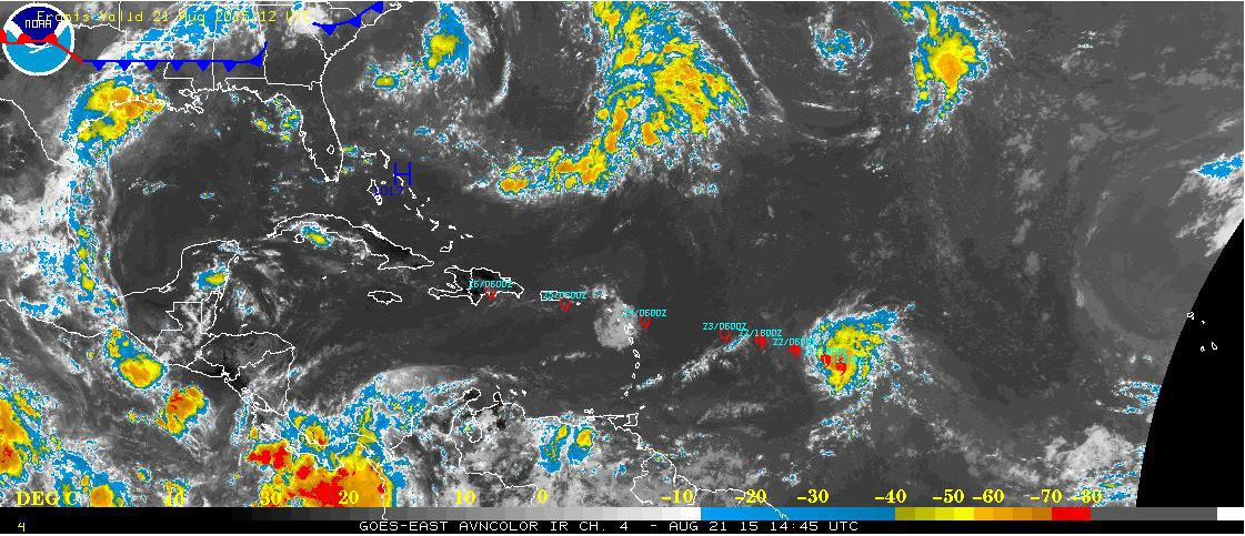
The Tropical Weather Outlook
For the North Atlantic...Caribbean Sea and the Gulf of Mexico:
1. Synopsis...A tropical wave will pass through the central Caribbean today...and through the W Caribbean on at into Sun. Hurricane Danny is expected to cross 55W on Sat evening...move across the Leeward Islands on Sun night and Mon and then pass through the Puerto Rico area on Tue.
Hurricane Danny has strengthened a little...
Summary at 500 AM AST...0900 UTC
Location...14.0N 48.2W about 2556 mi...ESE of the Bay Islands
Maximum sustained winds...105 mph
Present movement...WNW or 290 degrees at 10 mph
All interests in the Bay Islands and on the North Coast of Honduras should track this system as it moves west towards us.
2. The Saharan Air Layer (SAL) has again decreased in density.
3. For Roatan, Bay Islands, Honduras (16.38N, 86.45W): The approximate Closest Point of Approach (CPA) is located near 19.5N, 71.0W or about 1039.0 miles (1672.1 km) from your location. This is corresponding with the 120 hour position of the 5-day forecast (Wednesday, August 26 at 11:00AM AST).
Just for 'fun'... If the storm would continue on this track, the extrapolated closest point (X-CPA) is estimated at 23.4N, 84.1W or about 508.4 miles (818.3 km) from your location, where it can be in about 1 week, 13 hours and 48 minutes from now (Saturday, August 29 at 0:48AM AST, be aware that this location is not part of the official forecast and is prone to large errors). See Fig 22a
Just for 'fun'... If the storm would continue on this track, the extrapolated closest point (X-CPA) is estimated at 23.4N, 84.1W or about 508.4 miles (818.3 km) from your location, where it can be in about 1 week, 13 hours and 48 minutes from now (Saturday, August 29 at 0:48AM AST, be aware that this location is not part of the official forecast and is prone to large errors). See Fig 22a
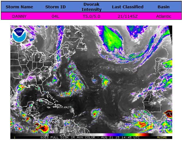


Fig 23 - 48 Hour Tropical Storm Probability
high tide 12:43 am LT Sunrise – 5:33 am LT>77° East
low tide 6:43 am LT Sunset – 6:08 pm LT < 283° West
high tide 2:44 pm LT Moon Rise – 11:04 am LT> 104° East
low tide 7:38 pm LT Moon Set – 11:02 pm LT < 255° West
low tide 6:43 am LT Sunset – 6:08 pm LT < 283° West
high tide 2:44 pm LT Moon Rise – 11:04 am LT> 104° East
low tide 7:38 pm LT Moon Set – 11:02 pm LT < 255° West

No comments:
Post a Comment