The
CoCoView Resort Weather Forecast
This weather
forecast is intended for CoCoView Resort guests and applies only to
the south side of Roatan
CoCoView is at 16.4°N
Latitude x 86.4°W Longitude
in the
NW Caribbean Sea
in the
NW Caribbean Sea
CoCoView Resort, www.cocoviewresort.com
, 800-510-8164
How to use this page:
The title of each of the
figures below is linked to the page where the information originates.
Since I write and post early
in the day and generally do not update the page until the next
morning; by clicking on the link, it allows you, the viewer, to get
the latest information.
This is not only convenient
but allows you to track weather events such as cold fronts and
hurricanes from a single web page.
In addition, in the right
column is a very useful widget. It is a trip planner...yesteryear's
weather at a glance.This widget lets you check historic weather for
your trip dates.
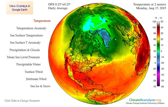
Skies will be partly cloudy. Winds will be mostly easterly in direction at 10 mph to 15 mph this morning; increasing to 20 mph to 30 mph this afternoon and evening. Seas will be choppy at 2 ft to 4 ft.
The air temperatures will range from the low to high 80s ºF or 26°C to 27ºC. Ocean water temperatures are 80°F to 82°F or 26ºC to 28ºC.
Shower activity associated with an area of low pressure located several hundred miles southwest of the Cape Verde Islands continues to show signs of organization. Environmental conditions appear conducive for development during the next few days, and a tropical depression will likely form by the middle of the week while the system moves westward or west-northwestward near 15 mph.
* Formation chance through 48 hours...medium...50 percent
* Formation chance through 5 days...high...70 percent
All interests in the Bay Islands and on the North Coast of Honduras should track this system as it moves west towards us. See Figs. 2, 2a, 2b, 22, 22a, 22b, 22c,and 23 below.


Fig
2a – Today's Jetstream


 |
Fig 20 - Recent changes in the
Saharan Air Layer
|
 |
The Tropical Weather Outlook
For the North Atlantic...Caribbean Sea and the Gulf of Mexico:
1. Synopsis...A tropical wave in the central Caribbean will move into the W Caribbean today and across Central America and Gulf of Honduras Tue. A tropical wave in the central Atlantic will move across the tropical N Atlantic waters Tue...reaching the Lesser Antilles Tue evening...move across the E Caribbean Tue night through Wed...and across the central Caribbean Wed and Thu.
2. Shower activity associated with an area of low pressure located several hundred miles southwest of the Cape Verde Islands continues to show signs of organization. Environmental conditions appear conducive for development during the next few days, and a tropical depression will likely form by the middle of the week while the system moves westward or west-northwestward near 15 mph.
* Formation chance through 48 hours...medium...50 percent
* Formation chance through 5 days...high...70 percent
All interests in the Bay Islands and on the North Coast of Honduras should track this system as it moves west towards us.
3. The Saharan Air Layer (SAL) has increased slightly in area and in density.
By:
Bob Henson
, 11:56 PM GMT on August 16, 2015
The outlook for 96L
The National Hurricane Center boosted the odds of development for 96L on Sunday afternoon, with a 50% chance of a tropical depression within 48 hours and a 60% chance in 120 hours. The 0000 GMT Monday update of the Atlantic Genesis Index from RAMMB/CIRA (Colorado State University) shows a 96% chance that 96L will develop into a depression over the next 48 hours and a 99% chance by 120 hours. The main factors behind these high probabilities are converging air at low levels, climatology, and relatively low vertical wind shear. Shear affecting 96L is projected to average only about 9 mph over the next five days, compared to an seasonal average of 22 mph, although shear will be gradually increasing through that five-day period. Sea-surface temperatures along 96L’s path will increase from about 26°C to 28°C, close to the climatological norm for the region and more than adequate for development.
Both the GFS and ECMWF operational models, our most reliable models for tropical cyclone track, bring 96L along a nearly due-west track over the next five days, with a gentle west-northwest turn by late in the week. The latest GFS ensemble includes some runs that move the system more rapidly toward the west-northwest. If the operational models are correct, 96L will remain south of 15°N though the upcoming week, keeping it over warm waters and well away from midlatitude systems that might interfere with its development. An upper-level trough will be sagging from the western Atlantic toward the Bahamas, potentially affecting 96L toward the weekend, but no large, deep troughs will be in place to steer the system dramatically northward for at least the next 5 or 6 days.
The intensity forecast for 96L is a bit more uncertain. Of the two most trusted models for intensity, the 1200 GMT Sunday run of the GFDL model brings 96L up to weak tropical-storm strength by midweek before a subsequent weakening. The 1200 GMT Sunday run of the HWRF model failed to develop 96L, but the 1800 GMT run brings 96L to midrange tropical storm strength by late Wednesday. Given the overall favorable conditions and the apparent healthiness of 96L’s structure, I’d rate the odds as being at least 50-50 that we will have a tropical storm in the central Atlantic before Friday.
Cape Verde season gears up
If 96L becomes a tropical storm, it will be Danny, the fourth named storm of this year’s Atlantic season. Based on data from 1966 through 2009, the fourth named storm typically occurs around August 23, so a tropical storm this week would be more or less on schedule. It would also be the first named storm to form in the Cape Verde region, where some of the most powerful Atlantic hurricanes originate. An informal definition of the peak Cape Verde season is from August 20 to September 20, although tropical storm formation becomes increasingly common throughout August across the deep tropics of the Atlantic. Already, a string of increasingly potent waves has been shuttling from Africa into the eastern Atlantic. However, all of these waves have collapsed as they approach the western Atlantic and the hostile conditions fostered by El Niño, including very high wind shear over the Caribbean and relatively stable air over much of the North Atlantic. Tropical cyclone activity often tapers off prematurely in the Atlantic during El Niño years, so it may become even more difficult to get Cape Verde storms toward September and October. We’ll see if this week’s wave happens to encounter El Niño at a weak point.
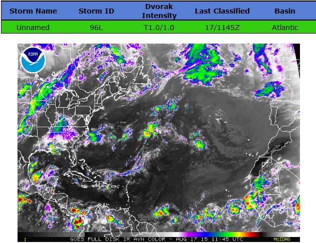

Fig 22a - Active Atlantic Ocean Tropical
Waves


Fig 23 - 48 Hour Tropical Storm Probability
low tide 4:03 am LT Sunrise – 5:32 am LT>76° East
high tide 10:35 am LT Sunset – 6:112 pm LT < 284° West
low tide 4:18 pm LT Moon Rise – 7:54 am LT> 89° East
high tide 10:02 pm LT Moon Set – 8:25 pm LT < 269° West
high tide 10:35 am LT Sunset – 6:112 pm LT < 284° West
low tide 4:18 pm LT Moon Rise – 7:54 am LT> 89° East
high tide 10:02 pm LT Moon Set – 8:25 pm LT < 269° West

No comments:
Post a Comment