The
CoCoView Resort Weather Forecast
This weather
forecast is intended for CoCoView Resort guests and applies only to
the south side of Roatan
CoCoView is at 16.4°N
Latitude x 86.4°W Longitude
in the
NW Caribbean Sea
in the
NW Caribbean Sea
CoCoView Resort, www.cocoviewresort.com
, 800-510-8164
How to use this page:
The title of each of the
figures below is linked to the page where the information originates.
Since I write and post early
in the day and generally do not update the page until the next
morning; by clicking on the link, it allows you, the viewer, to get
the latest information.
This is not only convenient
but allows you to track weather events such as cold fronts and
hurricanes from a single web page.
In addition, in the right
column is a very useful widget. It is a trip planner...yesteryear's
weather at a glance.This widget lets you check historic weather for
your trip dates.
Skies will be partly cloudy. Winds will be easterly in direction at 10 mph this morning or higher; increasing to 15 mph to 20 mph this afternoon and evening or higher. Seas will be choppy at 2 ft to 4ft.
The air temperatures will range from the low to high 80s ºF or 26°C to 27ºC. Ocean water temperatures are 80°F to 82°F or 26ºC to 28ºC.
There is a very slight chance of scattered rain showers and isolated thunderstorms, especially during the early morning, late night hours.


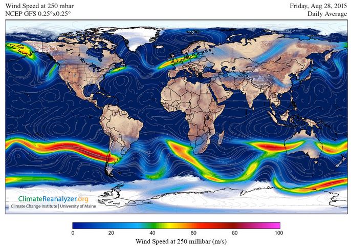
Fig
2a – Today's Jetstream


 |
Fig 20 - Recent changes in the
Saharan Air Layer
|
 |
The Tropical Weather Outlook
For the North Atlantic...Caribbean Sea and the Gulf of Mexico:
1. Synopsis..TS Erika near 17.7N 67.7W 1006 mb at 5 am moving W-NW or 290 deg at 15 kt. Maximum sustained winds 45 kt gusts 55 kt. Erika will continue W-NW across Hispaniola this afternoon and tonight and then emerge across the Atlantic reaching near 20.5N72.9W late tonight...then move NW between Cuba and the Bahamas. Then approach extreme S Florida Sun night. Only modest fluctuations in the strength of Erika are currently expected. Otherwise moderate to locally fresh trades will prevail..through Sat night...diminishing Sun afternoon. Confidence in the forecast track of this system is low.
All interests in the Bay Islands and on the North Coast of Honduras should continue to track this system until it makes a definite turn to the NW.
2. There is a tropical wave at 40W and three more about to move off West Africa into the Atlantic.
3. The Saharan Air Layer (SAL) has continued to increased slightly in density and decreased slightly in area.
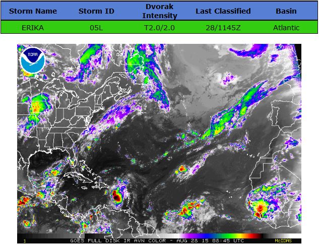

Fig 22a - Active Atlantic Ocean Tropical
Waves

Fig 23 - 48 Hour Tropical Storm Probability

Fig 23a - TS Ericka Computer Models
Fig 23b - TS Ericka CPA to Roatan

Results for Roatan, Bay Islands, Honduras (16.38N, 86.45W):
The approximate Closest Point of Approach (CPA) is located near 23.5N, 79.2W or about 679.6 miles (1093.7 km) from your location. This is corresponding with the 48 hour position of the 5-day forecast (Sunday, August 30 at 11:00AM AST).
Fig 23b - TS Ericka Distance from Roatan

low tide 1:15 am LT Sunrise – 5:34 am LT>80° East
high tide 7:07 am LT Sunset – 6:04 pm LT < 280° West
low tide 1:27 pm LT Moon Rise – 5:15 pm LT> 101° East
high tide 7:44 pm LT Moon Set – 4:15 am LT < 257° West
high tide 7:07 am LT Sunset – 6:04 pm LT < 280° West
low tide 1:27 pm LT Moon Rise – 5:15 pm LT> 101° East
high tide 7:44 pm LT Moon Set – 4:15 am LT < 257° West

No comments:
Post a Comment