The
CoCoView Resort Weather Forecast
This weather
forecast is intended for CoCoView Resort guests and applies only to
the south side of Roatan
CoCoView is at 16.4°N
Latitude x 86.4°W Longitude
in the
NW Caribbean Sea
in the
NW Caribbean Sea
CoCoView Resort, www.cocoviewresort.com
, 800-510-8164
How to use this page:
The title of each of the
figures below is linked to the page where the information originates.
Since I write and post early
in the day and generally do not update the page until the next
morning; by clicking on the link, it allows you, the viewer, to get
the latest information.
This is not only convenient
but allows you to track weather events such as cold fronts and
hurricanes from a single web page.
In addition, in the right
column is a very useful widget. It is a trip planner...yesteryear's
weather at a glance.This widget lets you check historic weather for
your trip dates.
Skies will be partly cloudy. Winds will be light and easterly in direction at 10 mph this morning or less; increasing to 10 mph to 15 mph this afternoon and evening. Seas will be calm at 1 ft to 2 ft.
The air temperatures will range from the low to high 80s ºF or 26°C to 27ºC. Ocean water temperatures are 80°F to 82°F or 26ºC to 28ºC.
There is a very slight chance of scattered rain showers and isolated thunderstorms, especially during the early morning, late night hours.


Fig
2a – Today's Jetstream


 |
Fig 20 - Recent changes in the
Saharan Air Layer
 |
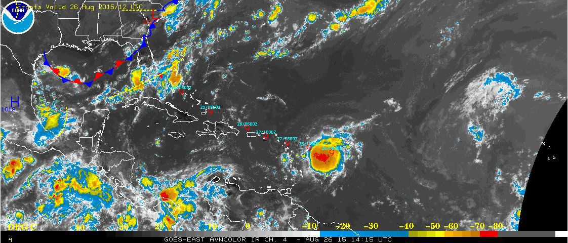
The Tropical Weather Outlook
For the North Atlantic...Caribbean Sea and the Gulf of Mexico:
1. Synopsis..Tropical Storm Erika near 16.1N 56.0W 1003 mb at 5 am EDT moving W at 16 kt. maximum sustained winds 35 kt gusts 45 kt. Erika will move to 16.5N 58.4W this afternoon...17.2N 61.5W late tonight...18.1N 64.5W Thu afternoon...and 26.0N 79.5W late Sun night while strengthening to a hurricane. The remnants of Danny in the form of a trough will move across the Greater Antilles through the upcoming weekend. Otherwise moderate to locally fresh trades will prevail.
All interests in the Bay Islands and on the North Coast of Honduras should track these systems as they move west towards us.
2. The Saharan Air Layer (SAL) has increased slightly in both density and area.
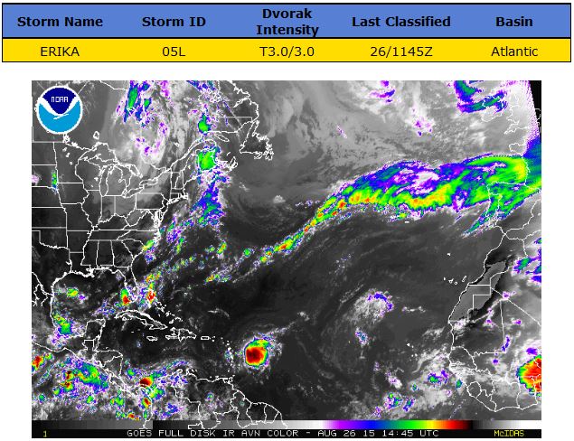
Results for Roatan, Bay Islands, Honduras (16.38N, 86.45W):
The approximate Closest Point of Approach (CPA) is located near 25.3N, 79.0W or about 783.7 miles (1261.3 km) from your location. The estimated time of when the center of the storm will be at that location is in about 4 days, 9 hours and 49 minutes from now (Sunday, August 30 at 9:48PM AST).
The approximate Closest Point of Approach (CPA) is located near 25.3N, 79.0W or about 783.7 miles (1261.3 km) from your location. The estimated time of when the center of the storm will be at that location is in about 4 days, 9 hours and 49 minutes from now (Sunday, August 30 at 9:48PM AST).


Fig 22a - Active Atlantic Ocean Tropical
Waves

Fig 23 - 48 Hour Tropical Storm Probability
high tide 5:34 am LT Sunrise – 5:34 am LT>79° East
low tide 12:02 pm LT Sunset – 6:05 pm LT < 281° West
high tide 6:40 pm LT Moon Rise – 3:27 pm LT> 107° East
low tide 12:35 am LT Moon Set – 2:15 am LT < 252° West
low tide 12:02 pm LT Sunset – 6:05 pm LT < 281° West
high tide 6:40 pm LT Moon Rise – 3:27 pm LT> 107° East
low tide 12:35 am LT Moon Set – 2:15 am LT < 252° West

No comments:
Post a Comment