Monday, October 31, 2016

Partly Sunny

The CoCoView Resort Weather Forecast
This weather forecast is intended for CoCoView Resort guests and applies only to the south side of Roatan
CoCoView is at 16.4°N Latitude x 86.4°W Longitude
in the
   NW Caribbean Sea

             CoCoView Resort, www.cocoviewresort.com , 800-510-8164


Monday, October 31, 2016
Skies will be partly sunny. There is a very slight chance of scattered rain showers and isolated thunderstorms, especially during the early morning, late night hours.Winds will be strong and mostly westerly in direction at 15 mph to 20 mph or higher.  Seas will be  moderate to rough at 1 to 4 ft. or higher.  The air temperatures will range from the high 70sºF to the mid to high 80s ºF or 26°C to 27ºC. Ocean water temperatures are 80°F to 82°F or 26ºC to 27ºC.


The Tropical Weather Outlook
For the North Atlantic...Caribbean Sea and the Gulf of Mexico:
Tropical cyclone formation is not expected for the next 48 hours.
1. Gulf of Mexico - Strong winds off Veracruz, Mexico will diminish today. High pressure N of area will be reinforced on Tue. Fresh to locally strong E winds will persist over the SE waters...including the Straits of Florida through early Tue night.
2. Caribbean Sea - A surface low over the NW Caribbean will weaken to a trough today with the trough gradually dissipating through Tue. High pressure building N of the area will result in strong NE winds developing in the Lee of Cuba late tonight. These strong conditions will spread across the Yucatan and Windward Passages on Tue night and continue through Wed.
3. Tropical cyclone formation is not expected for the next 48 hours.
4. . ...Caribbean Sea...
A large upper ridge is anchored in the Caribbean near 14N81W and dominates the entire Caribbean, Gulf of Mexico and the west Atlantic. At the surface is a 1009 mb low centered in the northwest Caribbean near 17N85W with a surface trough extending from 19N87W through the low to 15N82W. Scattered to numerous showers and isolated thunderstorms are from 16N-20N between 85W- 87W with scattered showers and isolated thunderstorms within 60/75 nm either side of the surface trough east of the low. Diffluence across the north Caribbean is generating lingering scattered showers north of 17N east of 80W from the Leeward Islands to Cuba. The low will weaken to a surface trough today with the trough gradually dissipating through Tuesday. Strong northeast winds will develop late tonight in the lee of Cuba as the high over the west Atlantic strengthens. These strong winds will spread across the Yucatan and with Windward Passages Tuesday night through Wednesday.
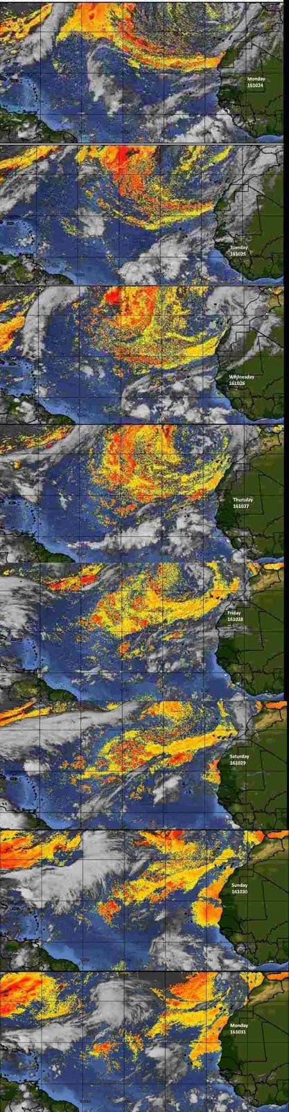
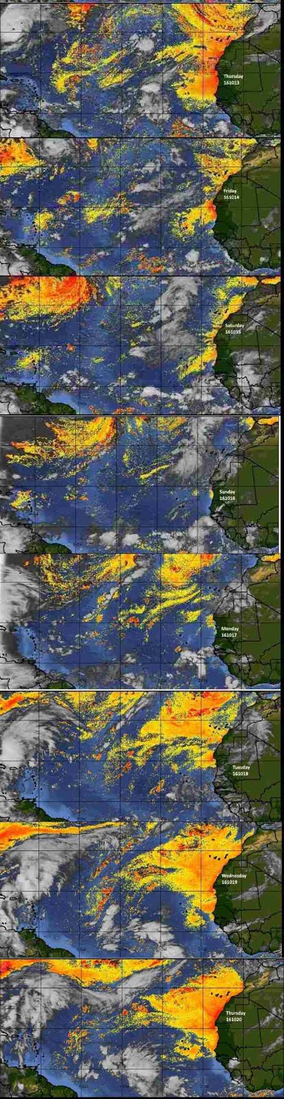
Fig 3 - Recent changes in the Saharan Air Layer
The Tides: Moon and Sun 
low tide  2:33am LT                         Sunrise – 5:44 am LT>105° East
high tide 9:31 am LT                        Sunset – 5:18 pm LT < 255° NW
low tide 3:09 pm LT                         Moon Rise – 6:24 am LT<103° East
high tide  8:12 pm LT                       Moon Set – 6:15 pm LT>256º West


Fig 4 - Moon

Day Light Hours:  11 hours, 33 minutes (-45s)

Sunday, October 30, 2016

Mostly Sunny

The CoCoView Resort Weather Forecast
This weather forecast is intended for CoCoView Resort guests and applies only to the south side of Roatan
CoCoView is at 16.4°N Latitude x 86.4°W Longitude
in the
   NW Caribbean Sea

             CoCoView Resort, www.cocoviewresort.com , 800-510-8164


Sunday, October 30, 2016
Skies will be mostly sunny. There is a very slight chance of scattered rain showers and isolated thunderstorms, especially during the early morning, late night hours.Winds will be strong and mostly westerly in direction at 15 mph to 25 mph or higher.  Seas will be  moderate to rough at 1 to 4 ft. or higher.  The air temperatures will range from the high 70sºF to the mid to high 80s ºF or 26°C to 27ºC. Ocean water temperatures are 80°F to 82°F or 26ºC to 27ºC.


The Tropical Weather Outlook
For the North Atlantic...Caribbean Sea and the Gulf of Mexico:
Tropical cyclone formation is not expected for the next 48 hours.
1. Gulf of Mexico - Fresh to strong easterly winds across the SE and S central Gulf will diminish by this afternoon as high pressure N of the area weakens. Strong winds off Veracruz, Mexico will diminish by this evening as well. Winds and seas will increase again over the Straits of Florida and SE Gulf Mon between building high pressure over the Carolinas and a trough over the SW Gulf...diminishing slightly by Thu as the high pressure weakens.
2. Caribbean Sea - A weak low and trough over the NW Caribbean will drift SW and dissipate on Mon. As high pressure builds N of area strong NE winds will develop in the lee of Cuba and Windward Passage Tue evening through Wed before diminishing Thu. A tropical wave will enter the E Caribbean today and weaken S of Puerto Rico on Mon.
3. ...Tropical Waves...
3a. Tropical wave east of the Windward Islands extends from 15N56W to 9N59W moving west 10 to 15 kt over the past 24 hours. Wave coincides with a 700 mb trough and is embedded within an area of deep moisture. No associated deep convection. Isolated showers and possible isolated thunderstorms are within 90 nm either side of the wave axis.

Fig 3 - Recent changes in the Saharan Air Layer
The Tides: Moon and Sun 
low tide  1:55 am LT                        Sunrise – 5:43 am LT>104° East
high tide 8:54 am LT                        Sunset – 5:18 pm LT < 256° NW
low tide 2:31 pm LT                         Moon Rise – 5:37 am LT<100° East
high tide  7:46 pm LT                       Moon Set – 5:34 pm LT>259º West

Fig 4 - Moon

Day Light Hours:  11 hours, 34 minutes (-46s)

Saturday, October 29, 2016

Mostly Sunny

The CoCoView Resort Weather Forecast
This weather forecast is intended for CoCoView Resort guests and applies only to the south side of Roatan
CoCoView is at 16.4°N Latitude x 86.4°W Longitude
in the
   NW Caribbean Sea

             CoCoView Resort, www.cocoviewresort.com , 800-510-8164


Saturday, October 29, 2016
Skies will be mostly sunny. Winds will be strong and mostly westerly in direction at 15 mph to 30 mph or higher.
Seas will be  moderate to rough at 1 to 4 ft. or higher.  The air temperatures will range from the high 70sºF to the mid to high 80s ºF or 26°C to 27ºC. Ocean water temperatures are 80°F to 82°F or 26ºC to 27ºC.


The Tropical Weather Outlook
For the North Atlantic...Caribbean Sea and the Gulf of Mexico:1. Gulf of Mexico - Strong easterly winds will persist across the SE and S central Gulf waters through early Sun between high pressure N of the area and low pressure over the NW Caribbean. Strong NW winds will continue along the coast of Veracruz, Mexico through late Sun. Strong winds will resume over the SE Gulf late Mon as the pressure gradient tightens again.
2. Caribbean Sea - A surface low near 18N84W will drift S and weaken to a trough on Sun and dissipate on Mon. Strong E winds N of the low will diminish this afternoon. Strong winds will develop to the lee of Cuba late Tue and spread across the waters N of 18N W of 74W on Wed. A weak tropical wave along 74W will lose identity by sun. A trough over the Leewards will continue W passing Puerto Rico tonight and reach the Dominican Republic on Sun. A tropical wave will pass through the tropical waters E of the Windwards tonight and enter the E Caribbean on Sun.
3. ...Tropical Waves...
3a. Tropical wave in the Tropical Atlantic extends along 51W/52W from 10N-17N moving west near 15 kt over the past 24 hours. Wave coincides with a 700 mb trough and is embedded within an area of moderate moisture. No associated deep convection.
3b. Tropical wave in the Caribbean extends along 75W south of 18N to inland over Colombia moving west near 10 kt over the past 24 hours. Wave coincides with weak 700 mb trough south of 13N and is embedded within an area of deep moisture. No associated deep convection. Scattered showers and isolated thunderstorms are from 16N-18N between 74W-77W.
Fig 3 - Recent changes in the Saharan Air Layer
The Tides: Moon and Sun
low tide  1:30 am LT                        Sunrise – 5:43 am LT>104° East
high tide 8:18 am LT                        Sunset – 5:18 pm LT < 256° NW
low tide 1:57 pm LT                         Moon Rise – 4:49 am LT<96° East
high tide  7:24 pm LT                       Moon Set – 4:59 pm LT>262º West

Fig 4 - Moon

Day Light Hours:  11 hours, 35 minutes (-46s)

Friday, October 28, 2016

Mostly Sunny and Windy

The CoCoView Resort Weather Forecast
This weather forecast is intended for CoCoView Resort guests and applies only to the south side of Roatan
CoCoView is at 16.4°N Latitude x 86.4°W Longitude
in the
   NW Caribbean Sea

             CoCoView Resort, www.cocoviewresort.com , 800-510-8164


Friday, October 28, 2016
Skies will be mostly sunny. Winds will be strong and mostly westerly in direction at 15 mph to 30 mph or higher.  There is a very slight chance of scattered rain showers and isolated thunderstorms today.
Seas will be  moderate to calm at 1 to 4 ft. or less.  The air temperatures will range from the high 70sºF to the mid to high 80s ºF or 26°C to 27ºC. Ocean water temperatures are 80°F to 82°F or 26ºC to 27ºC.


The Tropical Weather Outlook
For the North Atlantic...Caribbean Sea and the Gulf of Mexico:1. Gulf of Mexico - Strong E winds will persist over SE and S central Gulf through Sun between high pressure N of the area and low pressure over the NW Caribbean. Strong to near gale force NW winds will continue near the coast of Veracruz, Mexico through Sat. Winds will gradually diminish early next week as the high pressure to the north weakens and the low pressure dissipates.
2. Caribbean Sea - A shear line extending west from Haiti to broad low pressure over the NW Caribbean will drift N and gradually dissipate through Sat night. Fresh to strong NE winds will persist across the NW Caribbean through tonight then develop again early Tue. A tropical wave along 70W will lose identity by Sat.
3. ...Tropical Waves...
3a. Disorganized showers and thunderstorms over the northwestern Caribbean Sea and the southeastern Gulf of Mexico are associated with a broad area of low pressure located about a hundred miles north of the coast of Honduras. While this system is producing winds to near gale force north of the center, development is not expected due to strong upper-level winds. The low is forecast to move little over the next few days, and locally heavy rainfall is possible across portions of the eastern Yucatan peninsula, Cuba, the Cayman Islands, and Jamaica through the weekend.
* Formation chance through 48 hours...low...near 0 percent
* Formation chance through 5 days...low...near 0 percent
3b. An Atlantic Ocean tropical wave is along 46W/47W from 16N southward, moving westward 10 to 15 knots. Convective precipitation: rainshowers are possible from 15N to 20N between 40W and 50W.
3c. A Caribbean Sea tropical wave is moving across the eastern parts of the Dominican Republic along 70W/71W, moving westward 10 to 15 knots. Convective precipitation: rainshowers are possible between 66W and 70W. Rainshowers also have been forming, dissipating, and re-forming between 68W and 74W during the last six hours or more.
Fig 3 - Recent changes in the Saharan Air Layer
The Tides: Moon and Sun
low tide  1:07 am LT                        Sunrise – 5:43 am LT>104° East
high tide 7:44 am LT                        Sunset – 5:19 pm LT < 256° NW
low tide 1:28 pm LT                         Moon Rise – 4:02 am LT<92° East
high tide  7:02 pm LT                       Moon Set – 4:16 pm LT>256º West
Fig 4 - Moon

Day Light Hours:   11 hours, 36 minutes (-46s)

Thursday, October 27, 2016

Mostly Sunny

The CoCoView Resort Weather Forecast
This weather forecast is intended for CoCoView Resort guests and applies only to the south side of Roatan
CoCoView is at 16.4°N Latitude x 86.4°W Longitude
in the
   NW Caribbean Sea

             CoCoView Resort, www.cocoviewresort.com , 800-510-8164


Thursday, October 27, 2016
Skies will be mostly sunny. Winds will be light and mostly westerly in direction at 5 mph to 20 mph or less.  There is a very slight chance of scattered rain showers and isolated thunderstorms today.
Seas will be  moderate to calm at 1 to 4 ft. or less.  The air temperatures will range from the high 70sºF to the mid to high 80s ºF or 26°C to 27ºC. Ocean water temperatures are 80°F to 82°F or 26ºC to 27ºC.


The Tropical Weather Outlook
For the North Atlantic...Caribbean Sea and the Gulf of Mexico:1. Gulf of Mexico - Strong high pressure will persist from the Carolinas to the coast of Texas through Sat supporting fresh to strong NE to E winds across the eastern Gulf and Straits of Florida through Sat. strong E winds will spread W into the south-central Gulf Fri through Sat. Strong to near gale force NW winds are forecast to develop near the coast of Veracruz tonight through Fri...then strong NW winds through late Sun night. Winds slowly diminish Sat night through Sun night as the high pressure weakens.
2. Caribbean Sea - A shearline extending from southern Haiti SW to along northern Jamaica and to near 20N86W will begin to lose its identity through Fri. Fresh NE winds will persist thereafter in the lee of Cuba and Windward Passage between weak troughing over the SW Caribbean and reinforcing high pressure to the N. A tropical wave near 67W will move across the eastern Caribbean through tonight...then weaken as it enters the central Caribbean tonight. The weak trough in the SW Caribbean will maintain light winds and minimal seas over the SW Caribbean Thu through early next week.
3. ...Tropical Waves...
3a. An Atlantic Ocean tropical wave is along 40W/41W from 16N southward, moving westward 10 to 15 knots. A 1011 mb low pressure center is near 09N36W. Convective precipitation: scattered strong from 08N to 13N between 30W and 40W.
3b. A Caribbean Sea tropical wave is along 66W/67W, moving westward 10 to 15 knots. Convective precipitation: isolated moderate from 10N to 20N between 60W and 70W.

Fig 3 - Recent changes in the Saharan Air Layer
The Tides: Moon and Sun 
low tide  12:44 am LT                      Sunrise – 5:42 am LT>103° East
high tide 7:09 am LT                        Sunset – 5:19 pm LT < 257° NW
low tide 1:00 pm LT                         Moon Rise – 3:14 am LT<88° East
high tide  6:38 pm LT                       Moon Set – 3:38 pm LT>270º West
                                                                                                                                        
 
Fig 4 - Moon

Day Light Hours:  11 hours, 36 minutes (-47s)

Wednesday, October 26, 2016

Mostly Sunny

The CoCoView Resort Weather Forecast
This weather forecast is intended for CoCoView Resort guests and applies only to the south side of Roatan
CoCoView is at 16.4°N Latitude x 86.4°W Longitude
in the
   NW Caribbean Sea

             CoCoView Resort, www.cocoviewresort.com , 800-510-8164


Wednesday, October 26, 2016
Skies will be mostly sunny. Winds will be light and mostly westerly in direction at 5 mph to 20 mph or less.  There is a very slight chance of scattered rain showers and isolated thunderstorms today.
Seas will be  moderate to calm at 1 to 4 ft. or less.  The air temperatures will range from the high 70sºF to the mid to high 80s ºF or 26°C to 27ºC. Ocean water temperatures are 80°F to 82°F or 26ºC to 27ºC.


The Tropical Weather Outlook
For the North Atlantic...Caribbean Sea and the Gulf of Mexico:1. Gulf of Mexico - Strong high pressure will persist from the Carolinas to the coast of Texas through Fri...then weaken some Sat night through Sun night. This will increase the NE to E winds across the eastern Gulf and Straits of Florida through Fri night...then begin to slowly diminish Sat night through Sun night. Strong E winds will spread W into the central Gulf Fri and into the western Gulf through Sat. Strong to near gale force NW winds are forecast to develop near the coast of Veracruz, Mexico Thu night through Sat.
2. Caribbean Sea - A shearline extending from the Windward Passage to NE of Honduras will persist through Thu. Fresh NE winds will persist thereafter in the lee of Cuba and Windward passage between weak troughing over the SW Caribbean and reinforcing high pressure to the N. A tropical wave axis near 64W will move across the E Caribbean through tonight...then weaken as it enters the central Caribbean on Thu.
3....Tropical Waves...
3a. An Atlantic Ocean tropical wave is along 36W/37W from 15N southward, moving westward 10 to 15 knots. Convective precipitation: numerous strong from 05N to 08N between 33W and 36W.
3b. A Caribbean Sea tropical wave is along 64W from 20N southward, moving westward 10 to 15 knots. Convective precipitation: widely scattered moderate to isolated strong from 10N to 20N between 55W and 70W.

Fig 3 - Recent changes in the Saharan Air Layer
The Tides: Moon and Sun
low tide  12:17 pm LT                      Sunrise – 5:42 am LT>103° East
high tide 6:32 am LT                        Sunset – 5:20 pm LT < 257° NW
low tide 12:30 pm LT                       Moon Rise – 2:26 am LT<84° East
high tide  6:11 pm LT                       Moon Set – 2:59 pm LT>274º West


Fig 4 - Moon

Day Light Hours:  11 hours, 37 minutes (-47s)

Tuesday, October 25, 2016

Again Partly Sunny

The CoCoView Resort Weather Forecast
This weather forecast is intended for CoCoView Resort guests and applies only to the south side of Roatan
CoCoView is at 16.4°N Latitude x 86.4°W Longitude
in the
   NW Caribbean Sea

             CoCoView Resort, www.cocoviewresort.com , 800-510-8164


Tuesday, October 24, 2016
Skies will be partly sunny. Winds will be light and mostly westerly in direction at 5 mph to 10 mph or less.  There is a very slight chance of scattered rain showers and isolated thunderstorms today.
Seas will be  moderate to calm at 1 to 3 ft. or less.  The air temperatures will range from the high 70sºF to the mid to high 80s ºF or 26°C to 27ºC. Ocean water temperatures are 80°F to 82°F or 26ºC to 27ºC.


The Tropical Weather Outlook
For the North Atlantic...Caribbean Sea and the Gulf of Mexico:1. Gulf of Mexico - High pressure across the area will be replaced by stronger higher pressure that builds southward along the Eastern U.S. coast beginning this afternoon and through Sat. This will increase the NE to E winds across the eastern Gulf and Straits of Florida through the period. Strong E winds will spread W into the eastern portion of the central Gulf Fri through Sat night.
2. Caribbean Sea - A shearline extending from the Windward Passage to E Honduras will persist through Wed night before it loses its identity as reinforcing high pressure builds N of the area. Fresh NE winds will persist in the lee of Cuba and Windward Passage between weak troughing over the SW Caribbean and reinforcing high pressure to the N. A tropical wave in the far E Caribbean will move across the rest of that portion of the sea through Wed evening...then weaken as it enters the central Caribbean on Thu.
3. ..Tropical Waves...
3a. An Atlantic Ocean tropical wave is along 37W/38W from 15N southward, moving westward 10 to 15 knots. Convective precipitation: widely scattered to scattered moderate and isolated strong from 03N to 10N between 30W and 40W.
3b. A Caribbean Sea tropical wave is along 61W/62W from 17N southward to Venezuela, moving westward 10 to 15 knots. Convective precipitation: widely scattered moderate to isolated strong from 12N to 16N between 60W and 64W. A surface trough is along 59W from 10N to 17N. Convective precipitation: isolated moderate to locally strong from 10N to 24N between 56W and 60W.
Fig 3 - Recent changes in the Saharan Air Layer
The Tides: Moon and Sun 
high tide 5:51 am LT                         Sunrise – 5:42 am LT>103° East
low tide 11:56 am LT                        Sunset – 5:20 pm LT < 257° NW
high tide 5:41 pm LT                         Moon Rise – 1:36 am LT<80° East
low tide  12:16 pm LT                       Moon Set – 2:19 pm LT>278º West
Fig 4 - Moon

Monday, October 24, 2016

Partly Sunny

The CoCoView Resort Weather Forecast
This weather forecast is intended for CoCoView Resort guests and applies only to the south side of Roatan
CoCoView is at 16.4°N Latitude x 86.4°W Longitude
in the
   NW Caribbean Sea

             CoCoView Resort, www.cocoviewresort.com , 800-510-8164


Monday, October 24, 2016
Skies will be partly sunny. Winds will be light and variable in direction at 5 mph to 15 mph or less.  There is a very slight chance of scattered rain showers and isolated thunderstorms today.
Seas will be  moderate to calm at 1 to 3 ft. or less.  The air temperatures will range from the high 70sºF to the mid to high 80s ºF or 26°C to 27ºC. Ocean water temperatures are 80°F to 82°F or 26ºC to 27ºC.


The Tropical Weather Outlook
For the North Atlantic...Caribbean Sea and the Gulf of Mexico:1. Gulf of Mexico - High pres across the area will be replaced by stronger high pres from the U.S. eastern seaboard that will build S over the eastern Gulf waters beginning Tue afternoon and continuing through the period. This will allow for E winds to increase over much of the eastern Gulf. The resultant E swell will spread into the eastern portion of the central Gulf S of 26N Thu through Fri night.
2. Caribbean Sea - A weakening stationary front extends from far eastern Cuba SW to 19N80W...and to just NE of the Gulf of Honduras. The front will dissipate by late Tue night as strong high pressure builds S across the NW and N central Caribbean. The high pressure will weaken some Thu through Fri night as possible broad low pressure moves WNW across the W Caribbean. A tropical wave extending from 17N55W to 09N58W will move across the remainder of the tropical N Atlantic through late tonight...then weaken as it moves across the E Caribbean Tue through Wed. A surface trough may approach the NE tropical N Atlantic from the E Thu through Fri night.
3. There are no tropical cyclones in the Atlantic at this time. Tropical cyclone formation is not expected for the next 48 hours.
4. ...Tropical Waves...
4a. Tropical wave extends from 07N31W to 14N32W moving W at 10-15 kt. The wave remains fairly low-amplitude and coincides with 700 mb troughing S of 13N between 28W-34W. Scattered moderate convection is from 04N-13N between 26W-34W.
4b. Tropical wave extends from 09N59W to 16N55W moving W at 10-15 kt. The wave coincides with global model indicated 700 mb troughing between 51W-61W with a maximum in 850 mb relative vorticity in the vicinity of the wave axis near 12N. No significant deep convection is associated with the wave at this time.
Fig 3 - Recent changes in the Saharan Air Layer
The Tides: Moon and Sun
high tide 5:02 am LT                         Sunrise – 5:42 am LT>102° East
low tide 11:14 am LT                        Sunset – 5:21 pm LT < 258° NW
high tide 5:06 pm LT                         Moon Rise – 12:44 am LT<76° East
low tide  11:42 pm LT                       Moon Set – 1:36 pm LT>282º West

                                                                                                                                       
Fig 4 - Moon

Day Light Hours:  11 hours, 39 minutes (-48s)

Sunday, October 23, 2016

Partly Sunny

The CoCoView Resort Weather Forecast
This weather forecast is intended for CoCoView Resort guests and applies only to the south side of Roatan
CoCoView is at 16.4°N Latitude x 86.4°W Longitude
in the
   NW Caribbean Sea

             CoCoView Resort, www.cocoviewresort.com , 800-510-8164


Sunday, October 23, 2016
Skies will be partly sunny. Winds will be light and variable in direction at 5 mph to 15 mph or less.
Seas will be  moderate to calm at 1 to 3 ft. or less.  The air temperatures will range from the high 70sºF to the mid to high 80s ºF or 26°C to 27ºC. Ocean water temperatures are 80°F to 82°F or 26ºC to 27ºC.


The Tropical Weather Outlook
For the North Atlantic...Caribbean Sea and the Gulf of Mexico:
1. Gulf of Mexico - A weakening stationary front over the SW Gulf will dissipate tonight. High pressure over the region will be replaced by stronger high pressure from the U.S. eastern seaboard that builds S over the eastern Gulf waters beginning on Tue afternoon and continuing through Thu. This will allow for E winds to increase over much of the eastern Gulf.
2. Caribbean Sea - A cold front is just N of the Yucatan Peninsula. The cold front will become stationary from the Windward Passage to NE Honduras by this evening...then begin to weaken late tonight...and gradually dissipate Mon through Tue night. A tropical wave located about 180 nm E of the tropical N Atlantic waters will move across those waters through Tue...then weaken as it moves into the E Caribbean Tue night through Wed night.
3. ...Tropical Waves...
3a.Tropical wave extends from 10N53W to 19N50W moving W at 10-15 kt. The wave coincides with global model indicated 700 mb troughing between 38W-55W with a maximum in 850 mb relative vorticity along the wave axis near 12N. No significant deep convection is associated with the wave at this time.

Fig 3 - Recent changes in the Saharan Air Layer
The Tides: Moon and Sun
high tide 4:02 am LT                         Sunrise – 5:41 am LT>102° East
low tide 10:23 am LT                        Sunset – 5:21 pm LT < 258° NW
high tide 4:26 pm LT                         Moon Rise – 12:44 am LT<73° East
low tide  11:01 pm LT                       Moon Set – 12:51 pm LT>285º West


Fig 4 - Moon

Day Light Hours:  11 hours, 40 minutes (-48s)

Saturday, October 22, 2016

Partly Sunny

The CoCoView Resort Weather Forecast
This weather forecast is intended for CoCoView Resort guests and applies only to the south side of Roatan
CoCoView is at 16.4°N Latitude x 86.4°W Longitude
in the
   NW Caribbean Sea

             CoCoView Resort, www.cocoviewresort.com , 800-510-8164


Saturday, October 22, 2016
Skies will be partly sunny. Winds will be light and variable in direction at 5 mph to 15 mph or less. There is a very slight chance of scattered rain showers and isolated thunderstorms today.
Seas will be  moderate to calm at 1 to 3 ft. or less.  The air temperatures will range from the high 70sºF to the mid to high 80s ºF or 26°C to 27ºC. Ocean water temperatures are 80°F to 82°F or 26ºC to 27ºC.


The Tropical Weather Outlook
For the North Atlantic...Caribbean Sea and the Gulf of Mexico:1. Gulf of Mexico - A cold front extending from the FL Keys to 22N90W to 21N96W will continue passing quickly SE across the rest of the Gulf today...and exit the far SE Gulf this evening. High pressure behind the front will build eastward through Mon...then become replaced by stronger high pressure that builds southward from the eastern United States late Mon through Wed night. These highs will support moderate to fresh easterlies Sun night through mid week.
2. Caribbean Sea - A broad area of low pressure will persist across the SW Caribbean through Sun. A cold front will move into the NW Caribbean this evening...then stall from the Windward Passage to E Honduras Sun...slowly dissipating early next week. A tropical wave will approach the far E portion of the tropical N Atlantic waters late Sun night...then cross most of those waters Mon through Tue night...and possibly reaching the far E Caribbean Sea Wed.
3. ...Special Features...
3a. As of 22/0900 UTC...a cold front extends across the Gulf of Mexico from 26N81W to 24N90W to 21N97W generating near gale to gale force NW to N winds generally S of 21N W of a surface trough analyzed from the front near 22N97W to 19N94W. These conditions are expected to continue through Saturday afternoon across portions of the SW Gulf of Mexico.
4. ...Tropical Waves...
4a. Tropical wave extends from 09N48W to 18N43W moving W at 10-15 kt. The wave coincides with global model indicated 700 mb troughing between 42W-51W with a maximum in 850 mb relative vorticity along the wave axis near 11N. Scattered moderate and isolated strong convection is from 07N-16N between 38W-51W.
Fig 3 - Recent changes in the Saharan Air Layer
The Tides: Moon and Sun
high tide 2:46 am LT                         Sunrise – 5:41 am LT>102° East
low tide 9:17 am LT                          Sunset – 5:22 pm LT < 258° NW
high tide 3:36 pm LT                         Moon Rise – 11:50 pm LT<73° East
low tide  10:09 pm LT                       Moon Set – 12:02 pm LT>288º West


Fig 4 - Moon

Day Light Hours:  11 hours, 40 minutes (-48s)

Friday, October 21, 2016

Again Partly Sunny

The CoCoView Resort Weather Forecast
This weather forecast is intended for CoCoView Resort guests and applies only to the south side of Roatan
CoCoView is at 16.4°N Latitude x 86.4°W Longitude
in the
   NW Caribbean Sea

             CoCoView Resort, www.cocoviewresort.com , 800-510-8164


Friday, October 21, 2016
Skies will be partly sunny. Winds will be light and variable in direction at 5 mph to 15 mph or less. There is a very slight chance of scattered rain showers and isolated thunderstorms today.
Seas will be  moderate to calm at 1 to 3 ft. or less.  The air temperatures will range from the high 70sºF to the mid to high 80s ºF or 26°C to 27ºC. Ocean water temperatures are 80°F to 82°F or 26ºC to 27ºC.


The Tropical Weather Outlook
For the North Atlantic...Caribbean Sea and the Gulf of Mexico:1. Gulf of Mexico - A cold front extending from SE Louisiana to inland far NE Mexico will race eastward...reaching from Tampa Bay, FL to the SW Gulf this evening...then move across the Straits of Florida Sat night. Strong NW to N Winds and building seas are expected behind the front off the coast of Tamaulipas and Veracruz, Mexico today...reaching minimal gale force this afternoon and tonight. High pressure will build in the wake of the front Sun and prevail through Tue night.
2. Caribbean Sea - A broad area of low pressure will persist across the SW Caribbean through early Sat. Northerly swell in the tropical N Atlantic will gradually decay through Sun...while mixed NE and E swell in the eastern Caribbean will decay through Sat. A cold front will move into the NW Caribbean Sat night...then stall from the Windward Passage to eastern Honduras Sun...and slowly dissipate early next week. A weak surface trough from eastern Jamaica SW to inland northern Nicaragua will be absorbed by the cold front.
3. ...Special Features...
3a. A broad area of low pressure is centered east of the northern Bahamas. The central pressure of the low is 1001 mb and is located near 28N73W. Scattered moderate convection and isolated tstms are within 150 nm from the low center. To the east of the low center, a rainband supported by a diffluent environment aloft generates scattered showers and tstms from 20N to 36N between 60W and 70W. Showers also continue across Hispaniola, mainly across Dominican Republic, with GOES QPE imagery showing there accumulations of up to 2 inches over the last 6 hours. There is still a medium chance for this system to become a subtropical or tropical cyclone before it merges with an approaching cold front well offshore of the United States east coast tonight. A tight pressure gradient between a cold front and high pressure building in its wake will generate gale force winds in the Gulf of Mexico tonight. The front is expected to be along 29N82W to 26N90W to 19N95W and the gale winds from 21N to 24N west of 96W with seas to 8 ft. These conditions are forecast through Saturday.
4.  ...Tropical Waves...
4a. Tropical wave is in the central Atlantic extending from 06N to 16N with axis near 44W, moving W at 15 kt over the past 24 hours. The wave is in a region of unfavorable to neutral deep layer wind shear. Furthermore, CIRA LPW imagery from surface to 850 mb show pockets of dry air in the wave environment while water vapor imagery show dry air in the middle to upper levels. These factors are limiting the convection to scattered showers from 06N to 14N between 37W and 53W.
Fig 3 - Recent changes in the Saharan Air Layer
The Tides: Moon and Sun
high tide 1:13 am LT                         Sunrise – 5:41 am LT>101° East
low tide 7:54 am LT                          Sunset – 5:22 pm LT < 259° NW
high tide 2:35 pm LT                        Moon Rise – 10:54 pm LT<72° East
low tide  9:02 pm LT                        Moon Set – 11:09 am LT>289º West
                                                                                                                                    
    
Fig 4 - Moon

Day Light Hours:  11 hours, 41 minutes (-49s)

Thursday, October 20, 2016

Partly Sunny

The CoCoView Resort Weather Forecast
This weather forecast is intended for CoCoView Resort guests and applies only to the south side of Roatan
CoCoView is at 16.4°N Latitude x 86.4°W Longitude
in the
   NW Caribbean Sea

             CoCoView Resort, www.cocoviewresort.com , 800-510-8164


Thursday, October 20, 2016
Skies will be partly sunny. Winds will be light and variable in direction at 5 mph to 15 mph or less. There is a very slight chance of scattered rain showers and isolated thunderstorms today.
Seas will be  moderate to calm at 1 to 3 ft. or less.  The air temperatures will range from the high 70sºF to the mid to high 80s ºF or 26°C to 27ºC. Ocean water temperatures are 80°F to 82°F or 26ºC to 27ºC.


The Tropical Weather Outlook
For the North Atlantic...Caribbean Sea and the Gulf of Mexico:1. Gulf of Mexico - A ridge will retreat E today as a cold front approaches the NW Gulf...moving into the NW Gulf tonight. The cold front will race E reaching from Tampa Bay, FL to the SW Gulf on Fri night...passing through the Straits of Florida Sat night. Strong winds and building seas are possible behind the front off the coast of Tamaulipas and Veracruz, Mexico starting Fri...reaching minimal gale force Fri afternoon and night. High pressure will build in the wake of the front Sun through Mon night.
2. Caribbean Sea - A broad area of low pressure will persist across the SW Caribbean through early Sat. Northerly swells in the tropicaL N Atlantic and Atlantic/Caribbean passages will gradually decay through the end of the week. A cold front will move into the NW Caribbean Sat night...stalling from the Windward Passage to eastern Honduras Sun...gradually dissipating early next week.
3. ...Special Features...
3a. An elongated non-tropical 1005 mb surface low is centered northeast of the central Bahamas near 26N73W. Scattered moderate convection and isolated tstms are from 20N to 30N between 56W and 76W. Showers associated with this low are also affecting Hispaniola and Puerto Rico. Although the associated shower and thunderstorm activity remains disorganized, environmental conditions could become a little more conducive for the low to acquire some tropical characteristics during the next day or so, and this system could still become a subtropical or tropical cyclone before it merges with a cold front over the western Atlantic late Friday. Regardless of development, locally heavy rainfall is possible over Hispaniola, Puerto Rico, and portions of the northern Leeward Islands through today.
3b.  Gale force winds are expected to develop in the Gulf of Mexico Friday night associated with a cold front that will enter the NW waters of the Gulf early Friday morning. NW to N gale force winds are forecast for the area S of 25N W of the front with seas to 10 ft.
4.  ...Tropical Waves...
4a. Tropical wave is in the central Atlantic extending from 06N to 15N with axis near 39W, moving W at 15 kt over the past 24 hours. The wave continues in a region of unfavorable deep layer wind shear. However, CIRA LPW imagery from surface to 850 mb show the wave is in an abundant moist environment that along with divergent upper level wind flow support scattered moderate convection from 01N to 15N between 31W and 45W.


Fig 3 - Recent changes in the Saharan Air Layer
The Tides: Moon and Sun
low tide 6:24 am LT                         Sunrise – 5:40 am LT>101° East
high tide 1:20 pm LT                       Sunset – 5:23 pm LT < 259° NW
low tide  7:28 pm LT                       Moon Rise – 9:57 pm LT<71° East
high tide 1:13 am LT                       Moon Set – 10:12 am LT>289º West
                                                                                                                                       
   
Fig 4 - Moon