The
CoCoView Resort Weather Forecast
This weather
forecast is intended for CoCoView Resort guests and applies only to
the south side of Roatan
CoCoView is at 16.4°N
Latitude x 86.4°W Longitude
in the
NW Caribbean Sea
in the
NW Caribbean Sea
CoCoView Resort, www.cocoviewresort.com
, 800-510-8164
How to use this page:
The title of each of the
figures below is linked to the page where the information originates.
Since I write and post early
in the day and generally do not update the page until the next
morning; by clicking on the link, it allows you, the viewer, to get
the latest information.
This is not only convenient
but allows you to track weather events such as cold fronts and
hurricanes from a single web page.
In addition, in the right
column is a very useful widget. It is a trip planner...yesteryear's
weather at a glance.This widget lets you check historic weather for
your trip dates.
2014 Hurricane Outlook
and Forecasts
The hurricane season in this
hemisphere starts on June 01 and ends on November 30.
During that time frame, for
your convenience, you will find a section below titled, "Tropical
Weather Outlook".
It will contain the daily
tropical storm outlook, forecast and storm track(s).
NOAA predicts
near-normal or below-normal 2014 Atlantic hurricane season.
El Niño is expected to
develop and suppress the number and intensity of tropical cyclones.
This year, the Saharan Air
Layer (SAL) has been decreasing in size and density since May 21,
2014. This is important because it has been postulated, that the SAL,
a cool, dry, layer of air which contains particles, may inhibit the
formation of tropical storms and hurricanes. In addition, as it
decreases in size and density, the probability of tropical storm
formation may increase.
The outlook calls for a 50
percent chance of a below-normal season, a 40 percent chance of a
near-normal season, and only a 10 percent chance of an above-normal
season. For the six-month hurricane season, which begins June
1, NOAA predicts a 70 percent likelihood of 8 to 13 named storms
(winds of 39 mph or higher), of which 3 to 6 could become hurricanes
(winds of 74 mph or higher), including 1 to 2 major hurricanes
(Category 3, 4 or 5; winds of 111 mph or higher).
These numbers are near or
below the seasonal averages of 12 named storms, six hurricanes and
three major hurricanes, based on the average from 1981 to 2010. The
Atlantic hurricane region includes the North Atlantic Ocean,
Caribbean Sea and Gulf of Mexico.
Thursday,
August 21, 2017
Today,
skies will be mostly sunny. Winds will be easterly in direction at 8
mph to 12 mph or less; increasing to 15 mph to 20 mph this afternoon
and evening. Seas
will be moderate to calm at 1 to 4 feet.The
air temperatures will range from the mid to high 70s (ºF) to the mid
to high 80s (ºF) or 24ºC to 26ºC. Ocean
water temperatures are 82°F to 84°F or 24ºC to 25ºC. Visibility
is 20 to 80 ft.


 |
|
|


Fig 19 - Recent changes in the
Saharan Air Layer
|

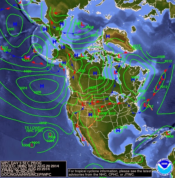
The Tropical Weather Outlook
Showers
and thunderstorms associated with an elongated area of low pressure,
designated Invest 96L, located a few hundred miles east of the
Windward Islands have changed little in organization during the past
several hours. Environmental conditions are expected to be conducive
for development during the next couple of days, and a tropical
depression could form while the system moves west-northwestward at
10 to 15 mph across the Lesser Antilles and over the eastern
Caribbean Sea. The mountainous terrain of Hispaniola and eastern
Cuba could limit development during the first part of the weekend,
but conditions are expected to be conducive for development early
next week when the system is forecast to move near or over the
Bahamas. Regardless of tropical cyclone formation, gusty winds and
heavy rainfall are possible across portions of the Lesser Antilles,
Puerto Rico, and the Virgin Islands tonight and Friday, and over
Hispaniola late Friday and Saturday. An Air Force Reserve Hurricane
Hunter aircraft is scheduled to investigate the low this afternoon,
if necessary.
*
Formation chance through 48 hours...medium...50 percent.
*
Formation chance through 5 days...high...70 percent.
All
interests in the Bay Islands and on the North Coast of Honduras
should monitor this system closely as it tracks westward toward us.
This
tropical low pressure near 14.5N 55.5W, will move NW today; crossing
the Lesser Antilles near 15N this evening...reach near 17N65W around
sunrise Friday...reach near the Mona Passage at sunset Friday...then
pass N of the Windward Passage at sunset on Saturday. This low has
the possibility of becoming a tropical cyclone.
A
tropical wave accompanying the low will continue W across the W
Caribbean on Sunday and Monday.
Disorganized 96L Bringing Heavy Rains to Lesser Antilles
By:
Dr. Jeff Masters
, 3:05 PM GMT on August 21, 2014
Figure 1. Radar image of 96L from 10:35 am EDT August 21, 2014. Image credit: Barbados Meteorological Services.
Forecast for 96L
Despite 96L's disorganized appearance on satellite imagery, the Thursday afternoon flight of the Hurricane Hunters is underway, but the earliest I would expect 96L to become a tropical depression would be Friday morning. The 0Z Thursday runs of our three most reliable models for predicting tropical cyclone genesis, the UKMET, GFS, and European models, had one model, the UKMET, predicting potential development into a tropical depression by Saturday. The storm will pass through the Lesser Antilles Islands Thursday and Friday, bringing heavy rain showers and strong winds, which will also affect the Virgin Islands, Puerto Rico, and Dominican Republic Friday through Saturday. A Flash Flood Watch is in effect from late Thursday night through Saturday morning for the Virgin Islands, Puerto Rico, Culebra, and Vieques. Rainfall amounts of 4 - 6" with locally higher amounts are expected.
Figure 2. Latest satellite image of 96L.
The circulation center of 96L has jumped considerably to the northwest over the past day, resulting in northward shifts in the expected track of the system from all of the major models. On Saturday, 96L may pass near or over the islands of Puerto Rico and Hispaniola, whose rugged terrain would likely disrupt the storm. By Sunday, 96L is expected to be near the Southeast Bahamas and Turks and Caicos Islands, and both the GFS and UKMET models predict that 96L will be able to develop into a tropical depression by Sunday or Monday. The 8 am EDT Thursday run of the SHIPS model predicted that wind shear would stay in the moderate range, 10 - 20 knots, though Sunday, then rise on Monday. With dry air expected to be in the region, wind shear would likely be able to drive the dry air into the circulation of 96L, keeping any development slow. A trough of low pressure is expected to be over the U.S. East Coast early next week, and the GFS and European models predict that this trough will be strong enough to turn 96L north and then northeast, keeping the storm away from the Southeast U.S. coast. However, long-range model forecasts of disturbances that haven't formed into a tropical depression yet are unreliable, and we should not be confident that 96L will miss the Mainland U.S. yet. In their 8 am EDT Thursday Tropical Weather Outlook, NHC gave the disturbance 2-day and 5-day development odds of 50% and 70%, respectively.
.jpg)

Fig 21a - Graphical 5 Day Tropical Weather Outlook


Fig 23 - 48 Hour Tropical Storm Probability


Fig 26 - Storm Statistics 96L
low
tide 12:41 am LT Moon Rise – 2:18 am LT
high
tide 6:17 am LT Moon Set –3:28 pm LT
low
tide 12:35 pm LT Sunrise – 5:33 am LT
high
tide 6:56 pm LT Sunset – 6:08 pm LT

No comments:
Post a Comment