The CoCoView
Resort Weather Forecast
This weather forecast is intended for CoCoView Resort guests and applies only to the south side of Roatan
CoCoView is at 16.4°N Latitude x 86.4°W Longitude
in the
NW Caribbean Sea
CoCoView Resort, www.cocoviewresort.com , 800-510-8164
How to use this page:
The title of each of the figures below is linked to the page where the information originates.
Since I write and post early in the day and generally do not update the page until the next morning; by clicking on the link, it allows you, the viewer, to get the latest information.
This is not only convenient but allows you to track weather events such as cold fronts and hurricanes from a single web page.
In addition, in the right column is a very useful widget. It is a trip planner...yesteryear's weather at a glance.This widget lets you check historic weather for your trip dates.
Friday Aug 29, 2013
Again,
today, skies
will be partly sunny.
Seas
will be moderate to calm at 1 to 3 feet.
Winds will be ESE to SE in direction, this morning, at 5 to 10 mph or
less; increasing this afternoon and evening to 15 to 20 mph. In the
afternoon, winds will be ENE in direction.
There is a chance of scattered rain showers and isolated thunderstorms through the weekend.
The air temperatures will range from the mid 80s (ºF) to the low 90s (ºF) or 25ºC to 32ºC.
Ocean water temperatures are 82°F to 84ºF or 27ºC to 28ºC. Visibility is generally 20 to 80 feet.
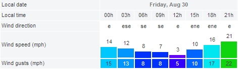


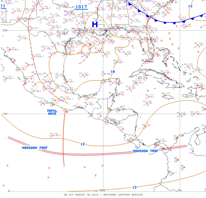


Fig 9a - Recent changes in the Saharan Air Layer

Invest 96L, the broad area of low pressure associated with a tropical wave has
slowed down. It is still located over extreme western Africa.
Environmental conditions appear conducive for further development...and this system has the potential to become a tropical depression during the
next couple of days when the low moves between the west coast of
Africa and the Cape Verde Islands. After that time...conditions are expected to become a less conducive for development as the
disturbance moves toward the west-northwest over the eastern
Atlantic. the system has a medium chance...40 percent...of becoming a tropical cyclone during the next 48 hours...and a high chance...60
percent...of becoming a tropical cyclone during the next 5 days. All
interests here should monitor this system for further development.
Shower activity associated with a tropical wave located about 700
miles east of the Lesser Antilles remains disorganized. This
disturbance is expected to move westward toward a region where the
upper-level winds are not favorable for development. This system has
a low chance...10 percent...of becoming a tropical cyclone during the
next 48 hours...and a low chance...20 percent...of becoming a
tropical cyclone during the next 5 days.
The SAL, has increased slightly in area and decreased in density.
See Figs. 9 and 9a.

high tide 4:59 am LT Moon Rise – 1:34 am LT
low tide 11:26 am LT Moon Set – 1:54 pm LT
high tide 5:54 pm LT Sunrise – 5:34 am LT
low tide 12:02 am LT Sunset – 6:02 pm LT

For text or mobile version go to: http://www.cocoviewresort.com/weather.php
No comments:
Post a Comment