The
CoCoView Resort Weather Forecast
This weather
forecast is intended for CoCoView Resort guests and applies only to
the south side of Roatan
CoCoView is at 16.4°N
Latitude x 86.4°W Longitude
in the
NW Caribbean Sea
in the
NW Caribbean Sea
CoCoView Resort, www.cocoviewresort.com
, 800-510-8164
Skies will be sunny. Winds will be easterly in direction at 10 mph to 25 mph or higher. Seas will be moderate to rough at 2 to 4 ft. or higher. Divers should exercise caution exiting and entering the boats, especially on the afternoon dives. The air temperatures will range from the high 70sºF to the mid to high 80s ºF or 26°C to 27ºC. Ocean water temperatures are 80°F to 82°F or 26ºC to 27ºC.

 |
The Tropical Weather Outlook
For the North Atlantic...Caribbean Sea and the Gulf of Mexico:1. Gulf of Mexico - A weak ridge across the northern Gulf will maintain gentle to moderate winds and modest seas across the Gulf waters through late in the week. A tropical wave will reach the SE Gulf and the Yucatan Peninsula early on Fri...and move across the Bay of Campeche, Mexico by early Sat...and amplify the usual surface trough that shifts W off the Yucatan Peninsula.
2. Caribbean Sea - A strong tropical wave over the central Caribbean between NW Venezuela and Dominican Republic continues to produce strong winds and rough seas over the NE and N central Caribbean. The tropical wave will gradually weaken as it moves W through the Western Caribbean Wed and Thu...then reaches the Yucatan Peninsula early on Fri. Another tropical wave is forecast to pass 55W Thu...enter the E Caribbean Thu night and enter the central Caribbean Sat.
3. ...Special Features...
3a. Post-tropical cyclone Hermine is centered near 39.6N 71.7W at 06/1200 UTC, or about 82 nm S of the eastern tip of Long Island. Hermine is moving W at 5 knots. The estimated minimum central pressure is 996 mb. Maximum sustained winds are 55 knots with gusts to 65 knots. Scattered showers are within 390 nm from the center to the NE and SW quadrants. A decrease in forward speed is expected later today, and Hermine will likely become nearly stationary by tonight. A turn toward the northeast is forecast to occur on Wednesday.
4. ...Tropical Waves...
4a. A tropical wave came off the West African coast earlier this morning. The wave extends from 06N to 18N with axis near 17W, expected to move at 10 kt within the next 24 hours. The wave is in a region of favorable deep layer wind shear and abundant low level moisture that along with diffluent flow aloft support heavy showers and tstms from 06N to 18N E of 20W.
4b. A tropical wave is over the central Atlc extending from 07N to 20N with axis near 38W, moving W at 5-10 kt within the last 24 hours. The wave is in a region of favorable deep layer wind shear and Saharan dry air and dust is not evident in its immediate environment anymore. However, both CIRA LPW show the wave axis is mainly in a dry environment, which is hindering convection and any development at the time.
4c. A tropical wave is over the central Caribbean Sea extending from 09N to 18N with axis near 70W, moving W at 20 kt within the last 24 hours. A 1010 mb center of low pressure is associated with the wave, located near 15N70W and expected to dissipate in less than 24 hours. Abundant moisture in the vicinity of the wave and a diffluent environment aloft support scattered heavy showers and isolated tstms from 15N to 18N between 68W and 70W and isolated showers elsewhere from 13N to 20N between 65W and 75W.
4d. A tropical wave extends from the Bay of Campeche to southern Mexico into the NE Pacific waters. The wave extends from 12N to 21N with axis near 94W, moving W at 15 kt within the last 24 hours. The wave is in a favorable deep layer wind shear environment that along with abundant low level moisture support scattered to isolated heavy showers and tstms across the W Bay of Campeche.
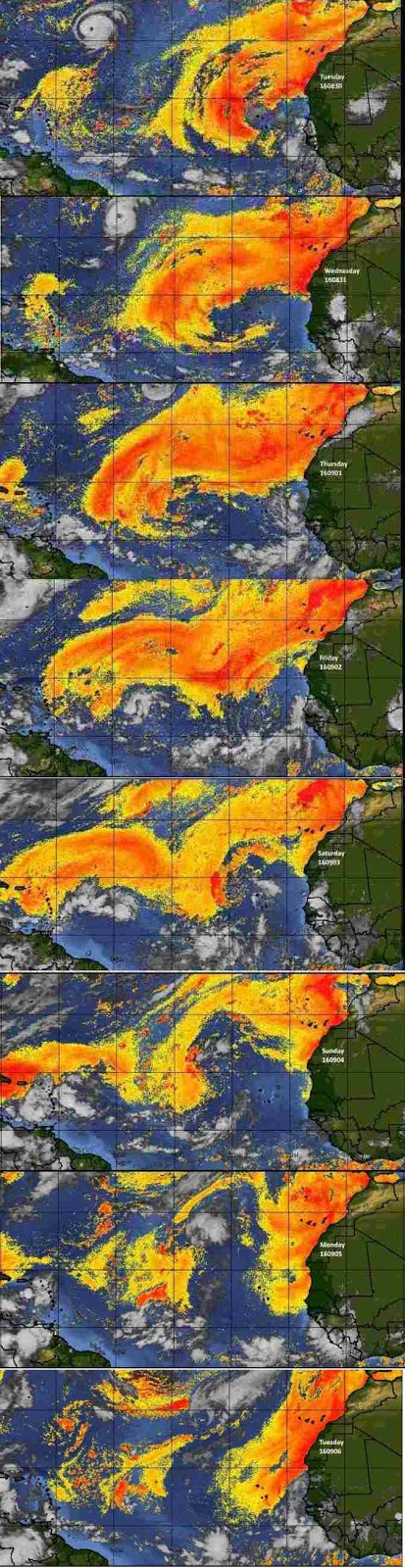
Fig 3
- Recent changes in the Saharan Air Layer
The Tides: Moon and
Sun
low tide 5:54 am LT Sunrise – 5:35 am LT>83° East
high tide 1:55 pm LT Sunset – 5:55 pm LT < 276° NW
low tide 6:57 pm LT Moon Rise – 09:46 pm LT<102° East
high tide 12:00 am LT Moon Set – 09:38 am LT>257º West
high tide 1:55 pm LT Sunset – 5:55 pm LT < 276° NW
low tide 6:57 pm LT Moon Rise – 09:46 pm LT<102° East
high tide 12:00 am LT Moon Set – 09:38 am LT>257º West

Fig 4 - Moon
Day Light Hours: 12 hours, 20 minutes (-51s)
No comments:
Post a Comment