The
CoCoView Resort Weather Forecast
This weather
forecast is intended for CoCoView Resort guests and applies only to
the south side of Roatan
CoCoView is at 16.4°N
Latitude x 86.4°W Longitude
in the
NW Caribbean Sea
in the
NW Caribbean Sea
CoCoView Resort, www.cocoviewresort.com
, 800-510-8164
Sunday, September 11, 2016
Skies will be mostly cloudy. Winds will be mostly easterly in direction at 5 mph to 20 mph or less. Seas will be moderate to calm at 1 to 3 ft. or higher. The air temperatures will range from the high 70sºF to the mid to high 80s ºF or 26°C to 27ºC. Ocean water temperatures are 80°F to 82°F or 26ºC to 27ºC.
Skies will be mostly cloudy. Winds will be mostly easterly in direction at 5 mph to 20 mph or less. Seas will be moderate to calm at 1 to 3 ft. or higher. The air temperatures will range from the high 70sºF to the mid to high 80s ºF or 26°C to 27ºC. Ocean water temperatures are 80°F to 82°F or 26ºC to 27ºC.


 |
The Tropical Weather Outlook
For the North Atlantic...Caribbean Sea and the Gulf of Mexico:1. Gulf of Mexico - A weak high pressure ridge across the N Gulf will shift N of the area Mon. A surface trough over the central Gulf will drift W to the SE TX coast through Mon. Weak low pres over the SE Gulf will weaken to a trough as it reaches the S central Gulf by Mon evening
2. Caribbean Sea - A tropical wave over the W Caribbean will move inland Central America Mon morning. Broad low pressure centered well E of the area early this morning near 15N46W will move NW during the next few days and generate NE to E swell expected to propagate into the tropical N Atlantic waters by Sun evening...then build and spread westward across Atlantic waters Mon night through Thu.
3. ...Special Features...
3a. An Atlantic Ocean tropical wave is along 46W/47W from 21N southward. A 1009 mb low pressure center is along the wave near 15N. The 06-hour forecast consists of a 1009 mb low pressure center near 17N 47.5W...a possible tropical cyclone. Expect gale- force winds and sea heights ranging from 10 feet to 14 feet, from 60 nm to 240 nm in the northern quadrant of the low center. Convective precipitation: widely scattered to scattered moderate and isolated strong from 06N to 22N between 40W and 55W. Environmental conditions are conducive for development. It is likely that a tropical depression may form later today or on Monday. This feature is forecast to move northwestward to north- northwestward in the central Atlantic Ocean. The chance of formation through 48 hours is high
4. ...Tropical Waves...
4a. An Atlantic Ocean tropical wave is along 19W from 20N southward. This position agrees with current satellite imagery. Convective precipitation: widely scattered moderate to isolated strong from 09N to 18N between Africa and 25W.
4b. An Atlantic Ocean tropical wave was added to the 11/0600 UTC surface map analysis, along 27W/28W, in agreement with the current satellite imagery. Convective precipitation: isolated moderate from 05N to 11N between 25W and 33W.
4c. A Caribbean Sea tropical wave is along 82W/83W, along the coast of Central America. Convective precipitation: widely scattered moderate to isolated strong from 17N southward from 78W westward to Central America.
4d. A Gulf of Mexico tropical wave is along 96W from 20N southward. Convective precipitation: numerous strong is inland in Mexico, and in the coastal waters, from 18N to 20N between 93W and 96W.

Fig 3
- Recent changes in the Saharan Air Layer
The Tides: Moon and
Sun
high tide 4:37 am LT Sunrise – 5:35 am LT>85° East
low tide 10:59 am LT Sunset – 5:52 pm LT < 274° NW
high tide 5:50 pm LT Moon Rise – 1:02 pm LT<109° East
low tide 11:35 pm LT Moon Set – 11:04 am LT>251º West
low tide 10:59 am LT Sunset – 5:52 pm LT < 274° NW
high tide 5:50 pm LT Moon Rise – 1:02 pm LT<109° East
low tide 11:35 pm LT Moon Set – 11:04 am LT>251º West
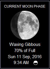
Fig 4 - Moon
No comments:
Post a Comment