The
CoCoView Resort Weather Forecast
This weather
forecast is intended for CoCoView Resort guests and applies only to
the south side of Roatan
CoCoView is at 16.4°N
Latitude x 86.4°W Longitude
in the
NW Caribbean Sea
in the
NW Caribbean Sea
CoCoView Resort, www.cocoviewresort.com
, 800-510-8164
How to use this page:
The title of each of the
figures below is linked to the page where the information originates.
Since I write and post early
in the day and generally do not update the page until the next
morning; by clicking on the link, it allows you, the viewer, to get
the latest information.
This is not only convenient
but allows you to track weather events such as cold fronts and
hurricanes from a single web page.
In addition, in the right
column is a very useful widget. It is a trip planner...yesteryear's
weather at a glance.This widget lets you check historic weather for
your trip dates.
2014 Hurricane Outlook
and Forecasts
The hurricane season in this
hemisphere starts on June 01 and ends on November 30.
During that time frame, for
your convenience, you will find a section below titled, "Tropical
Weather Outlook".
It will contain the daily
tropical storm outlook, forecast and storm track(s).
NOAA predicts
near-normal or below-normal 2014 Atlantic hurricane season.
El Niño is expected to
develop and suppress the number and intensity of tropical cyclones.
This year, the Saharan Air
Layer (SAL) has been decreasing in size and density since May 21,
2014. This is important because it has been postulated, that the SAL,
a cool, dry, layer of air which contains particles, may inhibit the
formation of tropical storms and hurricanes. In addition, as it
decreases in size and density, the probability of tropical storm
formation may increase.
The outlook calls for a 50
percent chance of a below-normal season, a 40 percent chance of a
near-normal season, and only a 10 percent chance of an above-normal
season. For the six-month hurricane season, which begins June
1, NOAA predicts a 70 percent likelihood of 8 to 13 named storms
(winds of 39 mph or higher), of which 3 to 6 could become hurricanes
(winds of 74 mph or higher), including 1 to 2 major hurricanes
(Category 3, 4 or 5; winds of 111 mph or higher).
These numbers are near or
below the seasonal averages of 12 named storms, six hurricanes and
three major hurricanes, based on the average from 1981 to 2010. The
Atlantic hurricane region includes the North Atlantic Ocean,
Caribbean Sea and Gulf of Mexico.
Tuesday,
September 09, 2014
Today,
skies will be partly sunny. Winds will be easterly in direction at 5
mph to 10 mph or less. Seas
will be moderate to calm at 1 to 3 feet. Expect increasing
cloudiness, as a tropical wave passes over us today and tomorrow.
There is a slight chance of scattered rain showers and thunder
storms.
The
air temperatures will range from the mid to high 70s (ºF) to the mid
to high 80s (ºF) or 24ºC to 26ºC.
Ocean
water temperatures are 82°F to 84°F or 24ºC to 25ºC. Visibility
is 20 to 80 ft.


|
|


 |
|
Fig 19 - Recent changes in the
Saharan Air Layer
|

|
|
The Tropical Weather Outlook
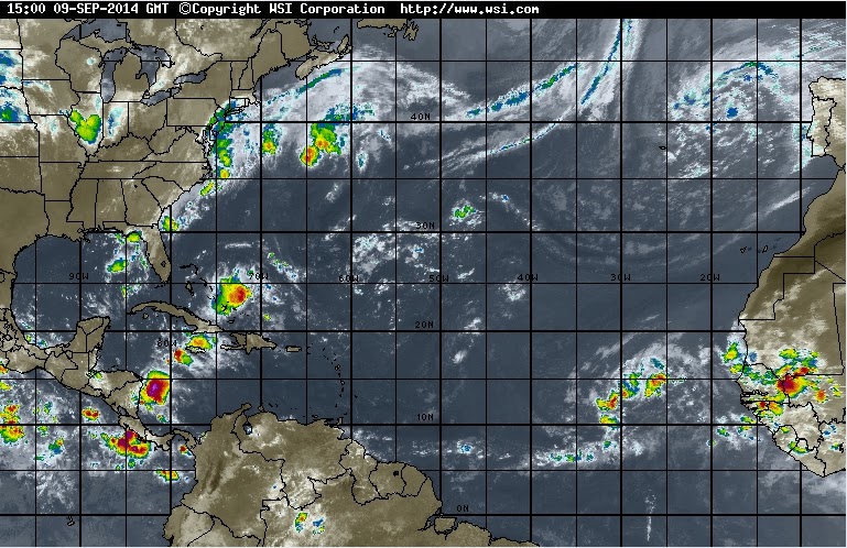
1.
A broad area of low pressure, designated Invest 91L, is located a few
hundred miles south of the Cape Verde Islands. It continues to
produce disorganized showers and thunderstorms. Environmental
conditions are forecast to be conducive for gradual development of
this disturbance during the next several days while it moves
west-northwestward at about 15 mph.
*
Formation chance through 48 hours...medium...30 percent.
*
Formation chance through 5 days...high...60 percent.
Currently
this system does not pose a threat to the Bay Islands and north coast
of Honduras. But all interests here should monitor it, as it moves
west towards us.
2.
A tropical wave currently along 82W will continue to move W through
the W Caribbean today and tonight. A second tropical wave along 45W
will pass through the tropical Atlantic waters Wednesday night...then
pass across the E Caribbean on Thursday and Friday reaching the
central Caribbean on Saturday.
Tropical Wave 91L
A tropical wave (91L) located a few hundred miles south of the Cape Verde Islands is headed west-northwest at about 15 mph. Satellite images show 91L has a moderate amount of spin and heavy thunderstorm activity, but these thunderstorms are poorly organized. The disturbance is embedded in a moist air mass, has moderately warm (SSTs) of 28°C (83°F) beneath it, and is experiencing light wind shear. These conditions favor development. The 8 am EDT Tuesday run of the SHIPS model predicted that wind shear would remain light to moderate ( 5 - 15 knots) the atmosphere at mid-levels of the atmosphere (between 500 - 700 mb) will remain moist, favoring development. All three of our three reliable computer models for predicting tropical storm formation predict development of 91L over the next five days. In their 8 am EDT Tuesday Tropical Weather Outlook, NHC gave the system 2-day and 5-day odd of development odds of 30% and 70%, respectively. A trough of low pressure expected to push off the U.S. East Coast early next week should induce a more northwesterly track for 91L next week, and the disturbance does not appear to be a long-range threat to the Lesser Antilles Islands. It remains to be seen if 91L will be a long-range threat to Bermuda, the U.S. East Coast, or the Canadian Maritime Provinces late next week.


Fig 21a - Graphical 5 Day Tropical Weather Outlook


Fig 23 - 48 Hour Tropical Storm Probability


Fig 26 - Storm Statistics 91L
low
tide 2:29 am LT Moon Rise – 6:33 pm LT
high
tide 8:47 am LT Moon Set –6:01 am LT
low
tide 2:50 pm LT Sunrise – 5:35 am LT
high
tide 8:45 pm LT Sunset – 5:54 pm LT

No comments:
Post a Comment