The
CoCoView Resort Weather Forecast
This weather
forecast is intended for CoCoView Resort guests and applies only to
the south side of Roatan
CoCoView is at 16.4°N
Latitude x 86.4°W Longitude
in the
NW Caribbean Sea
in the
NW Caribbean Sea
CoCoView Resort, www.cocoviewresort.com
, 800-510-8164
How to use this page:
The title of each of the
figures below is linked to the page where the information originates.
Since I write and post early
in the day and generally do not update the page until the next
morning; by clicking on the link, it allows you, the viewer, to get
the latest information.
This is not only convenient
but allows you to track weather events such as cold fronts and
hurricanes from a single web page.
In addition, in the right
column is a very useful widget. It is a trip planner...yesteryear's
weather at a glance.This widget lets you check historic weather for
your trip dates.
Skies will be partly cloudy. Winds will be easterly in direction at 10 mph or less this morning; increasing to 15 mph to 20 mph this afternoon and evening. Seas will be calm at 1 ft to 4 ft.. There is a slight chance of intermittent rain, today. Expect light winds and seas through Wednesday. Expect cloudiness and intermittent rain through the end of the week.
The air temperatures will range from the low to high 80s (ºF) or 26°C to 27ºC. Ocean water temperatures are 80°F to 82°F or 26ºC to 28ºC. Visibility is 20 to 80 ft.


Fig
2a – Today's Jetstream


 |
Fig 20 - Recent changes in the
Saharan Air Layer
|
 |
The Tropical Weather Outlook
For the North Atlantic...Caribbean Sea and the Gulf of Mexico:
1. A tropical wave is over the eastern tropical Atlantic with axis near 27W moving W at approximately 15 to 20 kt. Scattered moderate convection is limited to the region of the ITCZ from 04N to 06N between 18W and 23W.
2. A tropical wave is on the western tropical Atlantic with axis near 44W moving W at approximately 15 kt. A middle to upper level diffluent environment support scattered moderate convection from the equator to 10N W of 42W.
3. A tropical wave is over Venezuela with axis near 66W extending into the Caribbean basin S of 15N...moving W at approximately 5 kt. There is no convection associated with the wave over the Caribbean.
4. A tropical wave is over the SW Caribbean with axis near 77W moving W at approximately 15 to 20 kt. Isolated showers are within 200 nm ahead of its axis S of 13N being supported by a diffluent environment aloft.
5. A tropical wave in the W central Caribbean will move W-NW across the western Caribbean through Mon night and reach the Yucatan Peninsula Tue night. Atlantic high pressure will build N of the area through mid week behind the tropical wave...increasing winds from the S central Caribbean to the NW Caribbean by mid week. Another tropical wave will move across the tropical N Atlantic waters Tue night and Wed and reach the Windward Islands Wed night.
6.Tropical cyclone formation is not expected in the next 24 to 48 hours.
7. The Saharan Air Layer (SAL) has decreased slightly in area and density.


Fig 22a - Active Atlantic Ocean Tropical
Waves

Fig 23 - 48 Hour Tropical Storm Probability
high tide 12:40 am LT Sunrise – 5:15 am LT >66° E
low tide 7:01 am LT Sunset – 6:18 pm LT <294° NW
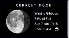
high tide 12:57 am LT Moon Rise – 10:55 pm LT >100° E
low tide 7:06 pm LT Moon Set – 9:56 am LT <258° W
low tide 7:01 am LT Sunset – 6:18 pm LT <294° NW
high tide 12:57 am LT Moon Rise – 10:55 pm LT >100° E
low tide 7:06 pm LT Moon Set – 9:56 am LT <258° W
No comments:
Post a Comment