The
CoCoView Resort Weather Forecast
This weather
forecast is intended for CoCoView Resort guests and applies only to
the south side of Roatan
CoCoView is at 16.4°N
Latitude x 86.4°W Longitude
in the
NW Caribbean Sea
in the
NW Caribbean Sea
CoCoView Resort, www.cocoviewresort.com
, 800-510-8164
How to use this page:
The title of each of the
figures below is linked to the page where the information originates.
Since I write and post early
in the day and generally do not update the page until the next
morning; by clicking on the link, it allows you, the viewer, to get
the latest information.
This is not only convenient
but allows you to track weather events such as cold fronts and
hurricanes from a single web page.
In addition, in the right
column is a very useful widget. It is a trip planner...yesteryear's
weather at a glance.This widget lets you check historic weather for
your trip dates.
Skies will be mostly cloudy. Winds will be variable in direction at 10 mph to less this morning; increasing to 12 mph to 15 mph or higher this afternoon and evening. Seas will be calm to moderate at 1 ft to 4 ft.. There is a 10% chance or higher of intermittent rain, today.
The air temperatures will range from the low to high 80s (ºF) or 26°C to 27ºC. Ocean water temperatures are 80°F to 82°F or 26ºC to 28ºC. Visibility is 20 to 80 ft.


Fig
2a – Today's Jetstream


 |
Fig 20 - Recent changes in the
Saharan Air Layer
|
 |
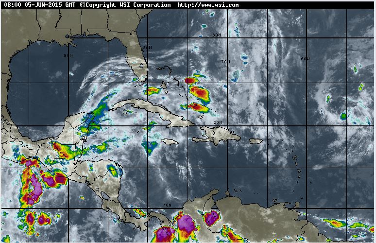
The Tropical Weather Outlook
For the North Atlantic...Caribbean Sea and the Gulf of Mexico:
1. An Atlantic ocean tropical wave is along 17W/18W from 13N southward...moving westward 10 to 15 kt. convective precipitation...nearby ITCZ-related isolated moderate.
2. An Atlantic ocean tropical wave is along 26W/27W from 9N southward...moving westward 10 to 15 kt. convective precipitation...nearby ITCZ-related isolated moderate.
3. An Atlantic ocean tropical wave is along 40W from 10N southward...moving westward 15 kt. convective precipitation...nearby ITCZ-related isolated moderate.
4. A Caribbean Sea tropical wave is along 61W/62W from 16N southward...moving westward 15 kt. convective precipitation... nearby ITCZ-related isolated moderate.
5. A broad surface trough will continue across the NW Caribbean through Sun...then weaken as moves westward across the Yucatan Peninsula Mon.
6.Tropical cyclone formation is not expected in the next 24 to 48 hours.


Fig 22a - Active Atlantc Ocean Tropical
Waves

Fig 23 - 48 Hour Tropical Storm Probability
low tide 4:56 am LT Sunrise – 5:15 am LT >66° E
high tide 10:11 am LT Sunset – 6:17 pm LT <294° NW
low tide 4:45 pm LT Moon Rise – 9:11 pm LT >106° E
high tide 11:41 pm LT Moon Set – 8:00 am LT <252° W
high tide 10:11 am LT Sunset – 6:17 pm LT <294° NW
low tide 4:45 pm LT Moon Rise – 9:11 pm LT >106° E
high tide 11:41 pm LT Moon Set – 8:00 am LT <252° W

No comments:
Post a Comment