The
CoCoView Resort Weather Forecast
This weather
forecast is intended for CoCoView Resort guests and applies only to
the south side of Roatan
CoCoView is at 16.4°N
Latitude x 86.4°W Longitude
in the
NW Caribbean Sea
in the
NW Caribbean Sea
CoCoView Resort, www.cocoviewresort.com
, 800-510-8164
How to use this page:
The title of each of the
figures below is linked to the page where the information originates.
Since I write and post early
in the day and generally do not update the page until the next
morning; by clicking on the link, it allows you, the viewer, to get
the latest information.
This is not only convenient
but allows you to track weather events such as cold fronts and
hurricanes from a single web page.
In addition, in the right
column is a very useful widget. It is a trip planner...yesteryear's
weather at a glance.This widget lets you check historic weather for
your trip dates.
Skies will be cloudy. This morning, winds will be easterly in direction at 10 mph or less; increasing to 15 mph to 25 mph this afternoon and evening. Seas will be moderate at 2 ft to 4 ft.. There is a chance of intermittent rain, today. Expect slightly higher winds and seas Wednesday through Friday. Expect cloudiness and intermittent rain through this Sunday.
The air temperatures will range from the low to high 80s (ºF) or 26°C to 27ºC. Ocean water temperatures are 80°F to 82°F or 26ºC to 28ºC. Visibility is 20 to 80 ft.


Fig
2a – Today's Jetstream


 |
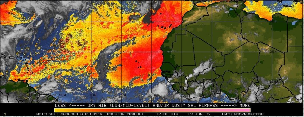
Fig 20 - Recent changes in the
Saharan Air Layer
|
 |
The Tropical Weather Outlook
For the North Atlantic...Caribbean Sea and the Gulf of Mexico:
1. Tropical wave in the central tropical Atlantic extends along 35W from 5N-15N moving W at 5-10 kt over the past 24 hours. Total precipitable water vapory imagery shows the wave embedded in a surge of deep moisture. Scattered moderate convection is from 7N- 10N between 36W-38W.
2.Tropical wave in the W tropical Atlantic extends along 55W S of 12N to inland over South America near 6N moving W-NW near 15 KT over the past 24 hours. Total precipitable water vapory imagery shows the wave at the leading edge of a low amplitude surge of deep moisture. Clusters of scattered moderate convection are from 6N- 10N between 50W-57W being enhanced by a cutoff upper low just NW of the wave.
3.Tropical wave in the SW Caribbean is along the coast of Nicaragua extending along 83W S of 16N to across Costa Rica moving W at 15-20 kt over the past 24 hours. Total precipitable water vapor imagery shows the wave embedded within a broad area of deep moisture that covers the entire SW Caribbean. Wave is beneath an upper ridge enhancing the scattered moderate/strong convection from 12N-18N between 80W-84W.
4. Synopsis...a trough on the northern portion of a tropical wave moving into Nicaragua will move over the NW Caribbean and into the Yucatan Peninsula tonight. A second tropical wave currently passing W of 55W will move through the Windward Islands tonight...across the E Caribbean through Thu...and the central Caribbean Fri and Sat. A third tropical wave will pass 55W Thu...approach the Windward Islands late Fri...and enter the E Caribbean Sat.
6.Tropical cyclone formation is not expected in the next 24 to 48 hours.
7. The Saharan Air Layer (SAL) remains moderately large in area and high in density.


Fig 22a - Active Atlantic Ocean Tropical
Waves

high tide 2:37 am LT Sunrise – 5:15 am LT >66° E
low tide 9:09 am LT Sunset – 6:18 pm LT <294° NW
high tide 3:37 am LT Moon Rise – 12:31 pm LT >91° E
low tide 9:36 pm LT Moon Set – 11:51 am LT <267° W
Day
Light Hours: 13 hours, 2 minute (+14 s) low tide 9:09 am LT Sunset – 6:18 pm LT <294° NW
high tide 3:37 am LT Moon Rise – 12:31 pm LT >91° E
low tide 9:36 pm LT Moon Set – 11:51 am LT <267° W
No comments:
Post a Comment