The CoCoView Resort Weather Forecast
This weather forecast is intended for CoCoView Resort guests and applies only to the south side of Roatan
CoCoView is at 16.4°N Latitude x 86.4°W Longitude
In the
NW Caribbean Sea
CoCoView Resort, www.cocoviewresort.com , 800-510-8164
The title of each of the figures below is linked to the page where the information originates.
Since I write and post early in the day and generally do not update the page until the next morning; by clicking on the link, it allows you, the viewer, to get the latest information.
This is not only convenient but allows you to track weather events such as cold fronts and hurricanes from a single web page.
In addition, in the right column are two very useful widgets. The first is a tropical weather tracker which shows you the location and forecast track of active tropical storm systems.
The second is a trip planner...yesteryear's weather at a glance.This widget lets you check historic weather for your trip dates.
Friday October 12, 2012
Again today, skies will be partly sunny, with mid to high level clouds. Seas will be choppy to rough at 2 to 4 feet. Winds will be easterly in direction at 10 to 25 mph.
There is a slight chance of isolated rain showers and thunderstorms in the early morning, late evening hours.
Winds will increase over NW Caribbean tonight through Saturday as strong high pres builds over eastern USA and diminish across the entire Caribbean Sunday through Tuesday.
The air temperatures will range from the low 80s (ºF) to the low 90s (ºF) or 26ºC to 32ºC.
Ocean water temperatures are 83 to 84ºF or 26 to 27ºC. Visibility is generally 20 to 80 feet.


The Tropical Weather Outlook
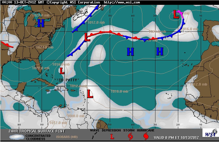
Invest 97L has become TS Patty and has strengthened slightly as it meanders well to the east of the Central Bahamas.
Patty is stationary...and some slow and erratic motion will be possible for the next 24 hours. A slow movement to the south or southwest is expected to begin Friday night (See Fig 13 ). Maximum sustained winds are near 45 mph...75 km/h...with higher gusts. Little change in strength is expected through Friday...with gradual weakening forecast to begin on Saturday.
Invest 98L, a low pressure system is now located about 30 miles east-southeast of Saint Lucia at 13.6N by 60.4W or about 1750 miles, E by S of the Bay Islands ( See Figs 14 and 15 ). It has changed little in organization during the past several hours, even though upper-level winds are only marginally favorable...slow development of this disturbance is possible during the next day or two. This system has a high chance...70 percent...of becoming a tropical cyclone during the next 48 hours as it moves northwestward or north-northwestward at 10 to 15 mph.
An Air Force Reserve Hurricane Hunter aircraft is scheduled to investigate this system this afternoon.
This system bears watching, as it continues to develop and generally tracks towards the Bay Islands. The consensus of the computer model runs is that it will continue to turn NW.


high tide 6:20 am LT Moon Rise – 2:47 am LT
low tide 12:19 am LT Moon Set – 3:24 pm LT
high tide 6:02 pm LT Sunrise – 5:39 am LT
low tide 12:28 am LT Sunset – 5:29 pm LT

No comments:
Post a Comment