The
CoCoView Resort Weather Forecast
This weather
forecast is intended for CoCoView Resort guests and applies only to
the south side of Roatan
CoCoView is at 16.4°N
Latitude x 86.4°W Longitude
in the
NW Caribbean Sea
in the
NW Caribbean Sea
CoCoView Resort, www.cocoviewresort.com
, 800-510-8164
How to use this page:
The title of each of the
figures below is linked to the page where the information originates.
Since I write and post early
in the day and generally do not update the page until the next
morning; by clicking on the link, it allows you, the viewer, to get
the latest information.
This is not only convenient
but allows you to track weather events such as cold fronts and
hurricanes from a single web page.
In addition, in the right
column is a very useful widget. It is a trip planner...yesteryear's
weather at a glance.This widget lets you check historic weather for
your trip dates.
Skies will be partly cloudy. Winds will be moderate and easterly in direction at 5 mph to 15 mph this morning; increasing to 15 mph to 25 mph this afternoon and evening. Seas will be calm to choppy at 1 ft to 4 ft.
The air temperatures will range from the low to high 80s ºF or 26°C to 27ºC. Ocean water temperatures are 80°F to 82°F or 26ºC to 28ºC.


Fig
2a – Today's Jetstream


 |
Fig 20 - Recent changes in the
Saharan Air Layer
|
 |
The Tropical Weather Outlook
For the North Atlantic...Caribbean Sea and the Gulf of Mexico:
1. SYNOPSIS...A tropical wave in the central Caribbean will pass through the SW Caribbean tonight through Tue night and through the Gulf of Honduras on Wed. A second tropical wave continue W through the central Caribbean this afternoon through Tue...reach the SW Caribbean on tue evening...and reach the Gulf of Honduras area on Wed night. The trades will increase to strong across the tropical waters near 16N55W on Thu evening in association with Tropical Storm Grace approaching.
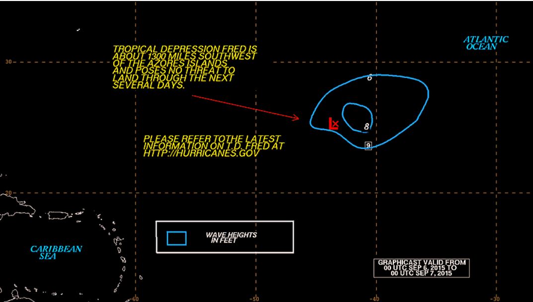
2. TD Fred turns northward. The center of Tropical Depression Fred at 06/0300 UTC is near 24.1N 43.1W. Fred is moving toward the northwest...or 320 degrees...09 knots. The maximum sustained wind speeds are 30 knots with gusts to 40 knots.
3. TS Grace is strengthening over the E Atlantic. The center of Tropical Storm Grace at 06/0300 UTC is near 12.8N 27.5W. Grace is moving toward the West...or 280 degrees...12 knots. The maximum sustained wind speeds are 35 knots with gusts to 45 knots.
All interests in the Bay Islands and on the North Coast of Honduras should monitor this system closely as it tracks westward toward us.
Currently TS Grace does not pose a threat to the Bay Islands and north coast of Honduras. But all interests here should monitor this system as it moves west towards us.
4. The Saharan Air Layer (SAL) has decreased slightly in area and density.
1. SYNOPSIS...A tropical wave in the central Caribbean will pass through the SW Caribbean tonight through Tue night and through the Gulf of Honduras on Wed. A second tropical wave continue W through the central Caribbean this afternoon through Tue...reach the SW Caribbean on tue evening...and reach the Gulf of Honduras area on Wed night. The trades will increase to strong across the tropical waters near 16N55W on Thu evening in association with Tropical Storm Grace approaching.
2. TD Fred turns northward. The center of Tropical Depression Fred at 06/0300 UTC is near 24.1N 43.1W. Fred is moving toward the northwest...or 320 degrees...09 knots. The maximum sustained wind speeds are 30 knots with gusts to 40 knots.
3. TS Grace is strengthening over the E Atlantic. The center of Tropical Storm Grace at 06/0300 UTC is near 12.8N 27.5W. Grace is moving toward the West...or 280 degrees...12 knots. The maximum sustained wind speeds are 35 knots with gusts to 45 knots.
All interests in the Bay Islands and on the North Coast of Honduras should monitor this system closely as it tracks westward toward us.
Currently TS Grace does not pose a threat to the Bay Islands and north coast of Honduras. But all interests here should monitor this system as it moves west towards us.
4. The Saharan Air Layer (SAL) has decreased slightly in area and density.


Fig 22a - Active Atlantic Ocean Tropical
Waves

Fig 23 - 48 Hour Tropical Storm Probability

Fig 23a - TS Grace Computer Models


Fig 23b - TS Grace, US Navy Fleet Weather Track and Forecast Track

Fig 23c - TS Grace Distance from Roatan

Fig 23d - TS Grace Model Track Guidance
high tide 4:05 am LT Sunrise – 5:35 am LT>83° East
low tide 10:47 am LT Sunset – 5:57 pm LT < 277° West
high tide 5:14 pm LT Moon Rise – 12:54 am LT> 71° East
low tide 11:29 pm LT Moon Set – 1:10 pm LT < 289° West
low tide 10:47 am LT Sunset – 5:57 pm LT < 277° West
high tide 5:14 pm LT Moon Rise – 12:54 am LT> 71° East
low tide 11:29 pm LT Moon Set – 1:10 pm LT < 289° West

No comments:
Post a Comment