The
CoCoView Resort Weather Forecast
This weather
forecast is intended for CoCoView Resort guests and applies only to
the south side of Roatan
CoCoView is at 16.4°N
Latitude x 86.4°W Longitude
in the
NW Caribbean Sea
in the
NW Caribbean Sea
CoCoView Resort, www.cocoviewresort.com
, 800-510-8164
How to use this page:
The title of each of the
figures below is linked to the page where the information originates.
Since I write and post early
in the day and generally do not update the page until the next
morning; by clicking on the link, it allows you, the viewer, to get
the latest information.
This is not only convenient
but allows you to track weather events such as cold fronts and
hurricanes from a single web page.
In addition, in the right
column is a very useful widget. It is a trip planner...yesteryear's
weather at a glance.This widget lets you check historic weather for
your trip dates.
Skies will be partly cloudy. Winds will be moderate and easterly in direction at 5 mph to 10 mph this morning; increasing to 15 mph to 20 mph this afternoon and evening. Seas will be calm to choppy at 1 ft to 3 ft.
The air temperatures will range from the low to high 80s ºF or 26°C to 27ºC. Ocean water temperatures are 80°F to 82°F or 26ºC to 28ºC.
There is a very slight chance of scattered rain showers and isolated thunderstorms later this evening or early tomorrow morning.


Fig
2a – Today's Jetstream


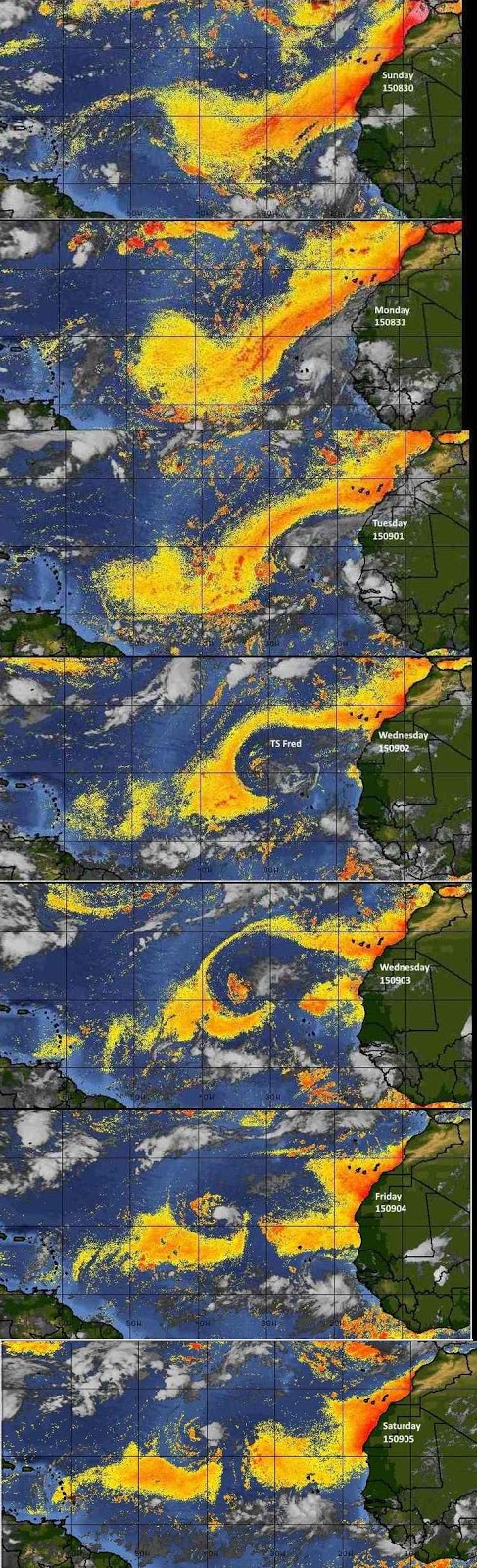 |
Fig 20 - Recent changes in the
Saharan Air Layer
|
 |
The Tropical Weather Outlook
For the North Atlantic...Caribbean Sea and the Gulf of Mexico:
1. Synopsis...A tropical wave will pass through the central Caribbean today through Sun...and pass through the W Caribbean on Sun night through Tue night. A second tropical wave will enter the E Caribbean late today...pass through the central Caribbean on Mon and Tue and the through the W Caribbean mid week.
2. Fred is still a tropical storm and is expected to turn northward during the weekend.
3. At 1100 AM AST (1500 UTC), the center of newly formed Tropical Depression Seven was located near latitude 12.3 North, longitude 25.2 West. The depression is moving toward the west near 14 mph (22 km/h), and this motion is expected to continue during the next two days.
Maximum sustained winds are near 35 mph (55 km/h) with higher gusts.
Some strengthening is possible during the next 48 hours, and the depression could become a tropical storm on Sunday. The estimated minimum central pressure is 1008 mb (29.77 inches).
3a.At 500 PM AST (2100 UTC), the center of Tropical Storm Grace was
located near latitude 12.6 North, longitude 26.4 West. Grace is
moving toward the west near 14 mph (22 km/h), and this general
motion is expected to continue for the next couple of days.
Maximum sustained winds have increased to near 40 mph (65 km/h) with
higher gusts. Some additional strengthening is expected during the
next day or so, with weakening possible by Monday.
Tropical storm force winds extend outward up to 35 miles (55 km)
from the center.
The estimated minimum central pressure is 1007 mb (29.74 inches).
All interests in the Bay Islands and on the North Coast of Honduras should monitor this system closely as it tracks westward toward us.
Currently this system does not pose a threat to the Bay Islands and north coast of Honduras. But all interests here should monitor this system as it moves west towards us. See Fig 23
4. The Saharan Air Layer (SAL) has increased slightly in area. See Fig. 20.
Currently this system does not pose a threat to the Bay Islands and north coast of Honduras. But all interests here should monitor this system as it moves west towards us. See Fig 23
4. The Saharan Air Layer (SAL) has increased slightly in area. See Fig. 20.


Fig 22a - Active Atlantic Ocean Tropical
Waves

Fig 23 - 48 Hour Tropical Storm Probability

Fig 23a - TS Seven Distance from Roatan


Fig 23b - US Navy Fleet Weather Track and Forecast Track for TD Seven

Fig 23c - TD Seven Computer Models

Fig 23d - TS Grace Computer Models
high tide 2:53 am LT Sunrise – 5:35 am LT>83° East
low tide 9:45 am LT Sunset – 5:58 pm LT < 277° West
high tide 4:25 pm LT Moon Rise – 12:02 pm LT> 71° East
low tide 10:39 pm LT Moon Set – 12:16 am LT < 288° West
low tide 9:45 am LT Sunset – 5:58 pm LT < 277° West
high tide 4:25 pm LT Moon Rise – 12:02 pm LT> 71° East
low tide 10:39 pm LT Moon Set – 12:16 am LT < 288° West

No comments:
Post a Comment