The
CoCoView Resort Weather Forecast
This weather
forecast is intended for CoCoView Resort guests and applies only to
the south side of Roatan
CoCoView is at 16.4°N
Latitude x 86.4°W Longitude
in the
NW Caribbean Sea
in the
NW Caribbean Sea
CoCoView Resort, www.cocoviewresort.com
, 800-510-8164
How to use this page:
The title of each of the
figures below is linked to the page where the information originates.
Since I write and post early
in the day and generally do not update the page until the next
morning; by clicking on the link, it allows you, the viewer, to get
the latest information.
This is not only convenient
but allows you to track weather events such as cold fronts and
hurricanes from a single web page.
In addition, in the right
column is a very useful widget. It is a trip planner...yesteryear's
weather at a glance.This widget lets you check historic weather for
your trip dates.
2014 Hurricane Outlook
and Forecasts
The hurricane season in this
hemisphere starts on June 01 and ends on November 30.
During that time frame, for
your convenience, you will find a section below titled, "Tropical
Weather Outlook".
It will contain the daily
tropical storm outlook, forecast and storm track(s).
NOAA predicts
near-normal or below-normal 2014 Atlantic hurricane season.
El Niño is expected to
develop and suppress the number and intensity of tropical cyclones.
This year, the Saharan Air
Layer (SAL) has been decreasing in size and density since May 21,
2014. This is important because it has been postulated, that the SAL,
a cool, dry, layer of air which contains particles, may inhibit the
formation of tropical storms and hurricanes. In addition, as it
decreases in size and density, the probability of tropical storm
formation may increase.
The outlook calls for a 50
percent chance of a below-normal season, a 40 percent chance of a
near-normal season, and only a 10 percent chance of an above-normal
season. For the six-month hurricane season, which begins June
1, NOAA predicts a 70 percent likelihood of 8 to 13 named storms
(winds of 39 mph or higher), of which 3 to 6 could become hurricanes
(winds of 74 mph or higher), including 1 to 2 major hurricanes
(Category 3, 4 or 5; winds of 111 mph or higher).
These numbers are near or
below the seasonal averages of 12 named storms, six hurricanes and
three major hurricanes, based on the average from 1981 to 2010. The
Atlantic hurricane region includes the North Atlantic Ocean,
Caribbean Sea and Gulf of Mexico.
Friday, November
14, 2014
Today, skies will be
partly sunny. Winds will be light and mostly northerly in direction
at 10 mph or less. Seas
will be calm at 1 to 3 feet. The air temperatures will range from the
mid to high 70s (ºF) to the mid to high 80s (ºF) or 24ºC to 26ºC.
Ocean water temperatures are 78°F to 82°F or 25ºC to 28ºC.
Visibility is 20 to 80 ft.
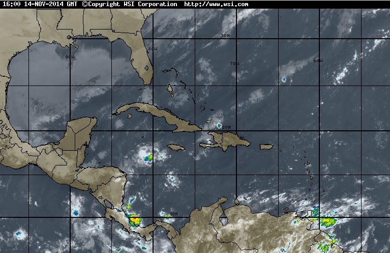
There is a slight chance of rain later in
the day. This morning a strong surface trough extends from 17N81W to off the coast of Nicaragua near 11N83W generating scattered showers and possible isolated thunderstorms within 60/75 nm either side of the trough axis.
It is moving E towards the Bay Islands and the north coast of Honduras. (See Fig. 13)


 |
|
|


 |
|
Fig 19 - Recent changes in the
Saharan Air Layer
|
 |
The Tropical Weather Outlook
For the North Atlantic...Caribbean Sea and the Gulf of
Mexico:
1. Tropical cyclone formation is not expected during
the next 5 days.
2. A weak pressure gradient across the forecast area
will maintain gentle to moderate winds through Fri night. The
pressure gradient will strengthen across the NW Caribbean during the
weekend...with moderate to occasionally fresh NE winds expected
before diminishing Sun late. Trades will pick up to a moderate to
fresh breeze across the central and E Caribbean...and tropical N
Atlantic Sun through Tue.
3. Gales along the coast of Mexico follow a cold front
from Tampa Bay, Florida through 24N90W to 19N92W. Winds will
diminish below gale force by midday Fri and below a strong breeze by
early Sat. Another strong front will move off the Texas coast late
Sun and reach from Panama City, Florida to the central Bay of
Campeche, Mexico by late Mon...and from Boca Grande, Florida to the
NE Yucatan Peninsula Tue. Another round of gales is possible Mon
through Tue across the far western and southwestern Gulf of Mexico behind the
next front.


Fig 21a - Graphical 5 Day Tropical Weather Outlook


Fig 23 - 48 Hour Tropical Storm Probability
high tide 3:44 am LT Moon Rise – 12:11 am LT
low tide 9:30 am LT Moon Set –12:05 pm LT
high tide 3:34 pm LT Sunrise – 5:48 am LT
low tide 10:22 pm LT Sunset – 5:11 pm LT
low tide 9:30 am LT Moon Set –12:05 pm LT
high tide 3:34 pm LT Sunrise – 5:48 am LT
low tide 10:22 pm LT Sunset – 5:11 pm LT

No comments:
Post a Comment