The
CoCoView Resort Weather Forecast
This weather
forecast is intended for CoCoView Resort guests and applies only to
the south side of Roatan
CoCoView is at 16.4°N
Latitude x 86.4°W Longitude
in the
NW Caribbean Sea
in the
NW Caribbean Sea
CoCoView Resort, www.cocoviewresort.com
, 800-510-8164
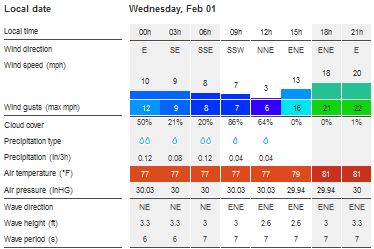
Skies will be partly cloudy. Winds will be variable in direction and light to moderate at 5 mph to 25 mph. Seas will be calm to moderate at 1 ft. to 4 ft. There is a very slight chance of rain showers and isolated thunderstorms today. The air temperatures will range from the low 70sºF to the low 80s ºF or 22°C to 24ºC. Ocean water temperatures are 76°F to 78°F or 24ºC to 25ºC.
 |
 |
The Tropical Weather Outlook
For the North Atlantic...Caribbean Sea and the Gulf of Mexico:
1. There are no tropical cyclones in the Atlantic at this time. The Atlantic hurricane season runs from June 1st through November 30th.
2. Gulf of Mexico - High pressure over the NE Gulf will change little through Fri. A cold front will cross the northern waters Fri night...weakening the high. The front will dissipate Sat with high pressure building back over the area. A thermal trough will cause enhanced nocturnal winds over the E Bay of Campeche, Mexico the next few nights.
3. Caribbean Sea - Fresh to strong winds will continue over the S central Caribbean through the forecast period. Gale winds near the coast of Colombia will decrease later this morning...then pulse to near gale force during the overnight hours each night the rest of the week. Trade wind swell will affect the Atlantic zones through Sun night.
3a. Upper level anticyclonic wind flow covers the area from 17N southward. SE-to-S wind flow from 350 mb to 500 mb covers the area from 66W eastward. Easterly wind flow from 600 mb to 800 mb is moving through the same area, from 66W eastward. Middle level to upper level cyclonic wind flow covers the waters that are to the south of Hispaniola, with a 16N68W cyclonic circulation center. Comparatively drier air, in subsidence, is apparent in water vapor imagery, across the entire Caribbean Sea. 24-HOUR rainfall amounts in inches, for the period ending at 01/0000 UTC, according to the PAN AMERICAN TEMPERATURE AND PRECIPITATION TABLES, MIATPTPAN/SXCA01 KNHC, are: 0.21 in Guadeloupe, and 0.19 in Curacao.

Fig 4
- Recent changes in the Saharan Air Layer
The Tides: Moon and
Sun
low tide 5:42 am LT Sunrise – 6:17 am LT>107° East
high tide 11:39 am LT Sunset – 5:45 pm LT < 253° NW
low tide 6:44 pm LT Moon Rise – 09:41 pm LT<89° East
high tide 01:17 am LT Moon Set – 10:10 am LT>274º West
high tide 11:39 am LT Sunset – 5:45 pm LT < 253° NW
low tide 6:44 pm LT Moon Rise – 09:41 pm LT<89° East
high tide 01:17 am LT Moon Set – 10:10 am LT>274º West

Fig 5 - Moon
Day Light Hours: 11 hours, 27 minutes, (+41s)
No comments:
Post a Comment