The
CoCoView Resort Weather Forecast
This weather
forecast is intended for CoCoView Resort guests and applies only to
the south side of Roatan
CoCoView is at 16.4°N
Latitude x 86.4°W Longitude
in the
NW Caribbean Sea
in the
NW Caribbean Sea
CoCoView Resort, www.cocoviewresort.com
, 800-510-8164
Sunday, February 05, 2017
Skies will be mostly cloudy. Winds will be easterly in direction and moderate at 5 mph to 25 mph. Seas will be moderate to calm at 1 ft. to 4 ft. There is a chance of intermittent rain showers and isolated thunderstorms today through Tuesday. The air temperatures will range from the mid 70sºF to the mid 80s ºF or 22°C to 24ºC. Ocean water temperatures are 79°F to 81°F or 26ºC to 27ºC.
Skies will be mostly cloudy. Winds will be easterly in direction and moderate at 5 mph to 25 mph. Seas will be moderate to calm at 1 ft. to 4 ft. There is a chance of intermittent rain showers and isolated thunderstorms today through Tuesday. The air temperatures will range from the mid 70sºF to the mid 80s ºF or 22°C to 24ºC. Ocean water temperatures are 79°F to 81°F or 26ºC to 27ºC.
|
|
|
|
The Tropical Weather Outlook
For the North Atlantic...Caribbean Sea and the Gulf of Mexico:
1. There are no tropical cyclones in the Atlantic at this time. The Atlantic hurricane season runs from June 1st through November 30th.
2. Gulf of Mexico - A dissipating cold front across the central Gulf has lifted N into Texas overnight while high pressure is nearly stationary across the SE U.S. high pressure will shift slowly E tonight through Tue and allow moderate to fresh return flow across NW portions this morning to spread E across entire basin by Mon night. The next strong cold front will move across the northern waters Wed night...and reach from the Florida Big Bend to upper Mexican coast Thu morning...and from near Naples, Florida to Tuxpan, Mexico by Thu evening. Strong high pressure behind front will produce strong N to NE winds.
3. Caribbean Sea - Strong to near gale force trades will continue over the S central Caribbean through Thu night...increasing to minimal gale force late at night through the early morning hours Sun through Mon along the NW coast of Colombia. Locally strong NE flow will develop tonight in the lee of the Dominican Republic and central Cuba..and in and downstream of the Windward Passage through early next week. E swell will maintain high seas across the tropical waters E of the Lesser Antilles through Thu night.
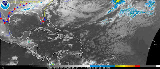
3a. Aside from the near gale to gale force winds occurring across a portion of the SW Caribbean...the remainder of the basin is expected to remain relatively tranquil as mostly dry air and subsidence prevails aloft as noted on water vapor imagery. Only a few isolated showers are possible across the SE waters and across portions of the western Caribbean along the coasts of Costa Rica...Panama...and Honduras. Otherwise...moderate to fresh trades prevail with little change expected through Monday.
Fig 4
- Recent changes in the Saharan Air Layer
The Tides: Moon and
Sun
high tide 5:05 am LT Sunrise – 6:16 am LT>106° East
low tide 10:54 am LT Sunset – 5:47 pm LT < 254° NW
high tide 4:23 pm LT Moon Rise – 12:54 pm LT<73° East
low tide 11:11 pm LT Moon Set – 1:03 am LT>286º West
low tide 10:54 am LT Sunset – 5:47 pm LT < 254° NW
high tide 4:23 pm LT Moon Rise – 12:54 pm LT<73° East
low tide 11:11 pm LT Moon Set – 1:03 am LT>286º West
Fig 5 - Moon
Day Light Hours: 11 hours, 30 minutes, (+43s)


No comments:
Post a Comment