The
CoCoView Resort Weather Forecast
This weather
forecast is intended for CoCoView Resort guests and applies only to
the south side of Roatan
CoCoView is at 16.4°N
Latitude x 86.4°W Longitude
in the
NW Caribbean Sea
in the
NW Caribbean Sea
CoCoView Resort, www.cocoviewresort.com
, 800-510-8164
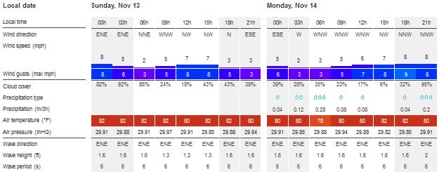
Skies will be partly cloudy. Winds will be light and variable in direction at 10 mph or less. Seas will be moderate to calm at 1ft. to 4ft. The full Moon of Nov. 14th will be the biggest and brightest in nearly 70 years. The air temperatures will range from the high 70sºF to the mid to high 80s ºF or 26°C to 27ºC. Ocean water temperatures are 80°F to 82°F or 26ºC to 27ºC.


 |
 |
The Tropical Weather Outlook
For the North Atlantic...Caribbean Sea and the Gulf of Mexico:
1. Tropical cyclone formation is not expected for the next 48 hours.
2. Gulf of Mexico - A stationary front extending from the Straits of Florida to the central Gulf near 23.5N90W to 1014 mb low pressure in the S Gulf near 20.5N94W will linger today. A new cold front in the NE Gulf will slowly seep S through Mon...acceleratingby mid- week...merging with the stationary boundary Wed...pushing SE of the basin by Thu as high pressure builds southward.
3. Caribbean Sea
3a. Mainly moderate to locally fresh trades will prevail across the basin...increasing to strong through the Windward Passage this evening...diminishing by early Mon. A weak cold front will move into the NW Caribbean late Tue night and stall from central Cuba to Honduras Thu. Broad low pressure is expected to develop across the SW Caribbean Wed through Thu. All interests in the Bay Islands and on the North Coast of Honduras should monitor this system closely as it tracks northward toward us. Currently this system does not pose a threat to the Bay Islands and north coast of Honduras. But it does have some potential to develop into a tropical storm or cyclone.3b. Upper level anticyclonic wind flow spans the area. A ridge extends from northern sections of Colombia and NW Venezuela northwestward, into the NW corner of the Caribbean Sea. A surface trough is along 79W/81W from 16N southward. Convective precipitation: scattered strong from 13N to 17N between 74W and 78W. Isolated to widely scattered moderate is elsewhere from 18N southward between 70W and 84W. 24-HOUR rainfall totals in inches for the period ending at 13/0000 UTC...according to the PAN AMERICAN TEMPERATURE AND PRECIPITATION TABLES...MIATPTPAN/SXCA01 KNHC...are 0.09 in Guadeloupe, and 0.01 in Merida, Mexico.

Fig 4
- Recent changes in the Saharan Air Layer
The Tides: Moon and
Sun
low tide 1:13 am LT Sunrise – 5:49 am LT>109° East
high tide 7:48 am LT Sunset – 5:14 pm LT < 251° NW
low tide 1:43 am LT Moon Rise – 4:49 pm LT<78° East
high tide 7:16 pm LT Moon Set – 4:43 am LT>280º West
high tide 7:48 am LT Sunset – 5:14 pm LT < 251° NW
low tide 1:43 am LT Moon Rise – 4:49 pm LT<78° East
high tide 7:16 pm LT Moon Set – 4:43 am LT>280º West

Fig 5 - Moon
Day Light Hours: 11 hours, 24 minutes (-38s)
No comments:
Post a Comment