The
CoCoView Resort Weather Forecast
This weather
forecast is intended for CoCoView Resort guests and applies only to
the south side of Roatan
CoCoView is at 16.4°N
Latitude x 86.4°W Longitude
in the
NW Caribbean Sea
in the
NW Caribbean Sea
CoCoView Resort, www.cocoviewresort.com
, 800-510-8164
How to use this page:
The title of each of the
figures below is linked to the page where the information originates.
Since I write and post early
in the day and generally do not update the page until the next
morning; by clicking on the link, it allows you, the viewer, to get
the latest information.
This is not only convenient
but allows you to track weather events such as cold fronts and
hurricanes from a single web page.
In addition, in the right
column is a very useful widget. It is a trip planner...yesteryear's
weather at a glance.This widget lets you check historic weather for
your trip dates.
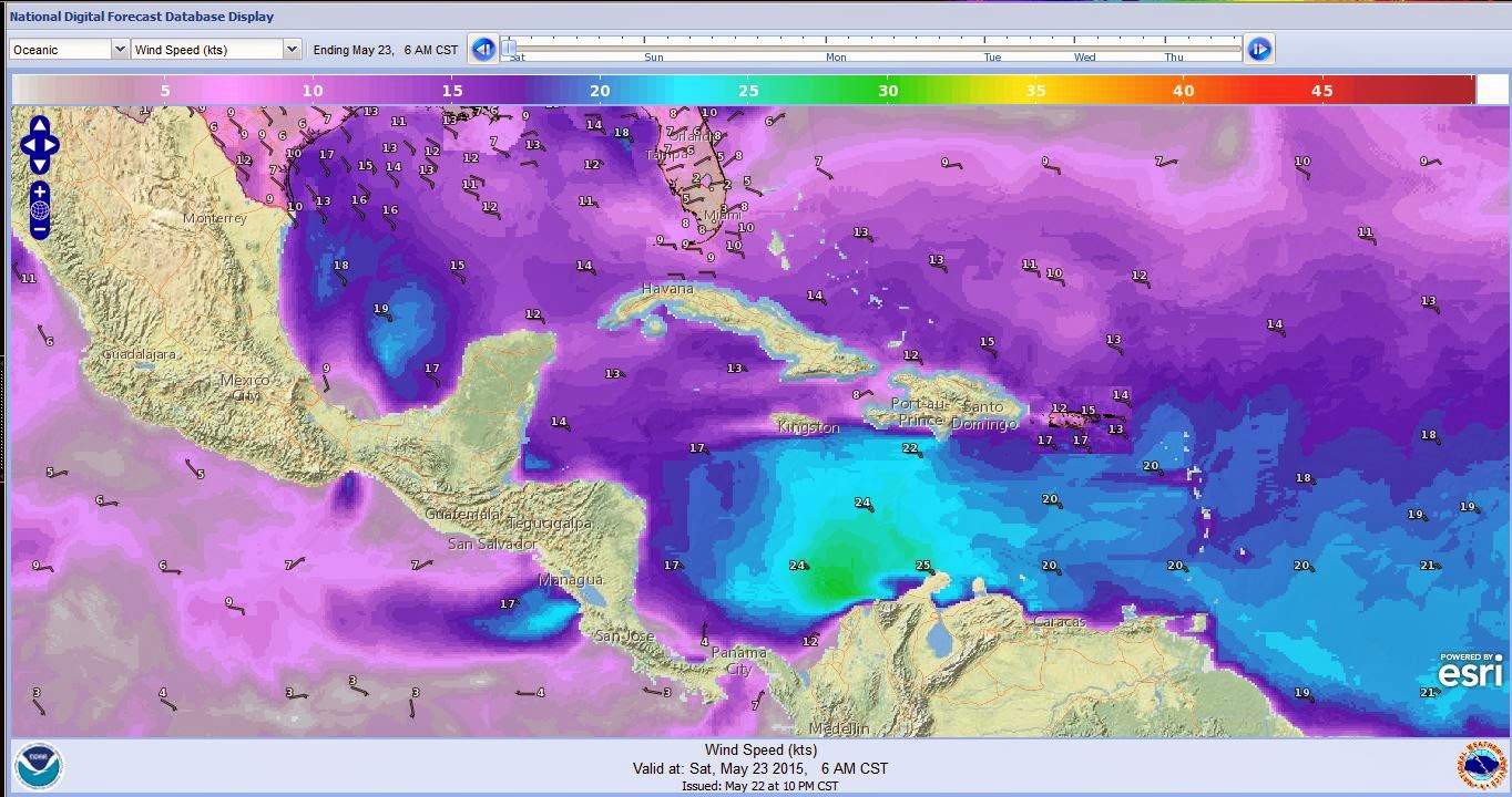
Skies will be partly sunny. Winds will be easterly in direction at 15 mph to 20 mph this morning; increasing to 20 mph to 25 mph this afternoon and evening or higher. Seas will be choppy to rough at 2 to 4 ft. or higher. Expect winds and seas to increase in strength through Monday. Divers should exercise caution exiting and entering the boats, especially on the afternoon dives. There is a chance of scattered rain showers and isolated thunderstorms, especially during the early morning, late night hours.
The air temperatures will range from the low to high 80s (ºF) or 26°C to 27ºC. Ocean water temperatures are 79°F to 81°F or 24ºC to 26ºC. Visibility is 20 to 80 ft.


Fig
2a – Today's Jetstream


 |
|
Fig 20 - Recent changes in the
Saharan Air Layer
|
 |
The Tropical Weather Outlook
For the North Atlantic...Caribbean Sea and the Gulf of Mexico:
1. A stationary front over the N Gulf of Mexico will dissipate by Sat night. Fresh NE to E winds are expected NW of the Yucatan each night due to local effects.
2. Moderate to fresh trades will prevail across most of the Caribbean area for several days. Winds and seas will increase over the central Caribbean this weekend as strong high pressure moves into the western Atlantic.


Fig 23 - 48 Hour Tropical Storm Probability
high tide 1:26 am LT Sunrise – 5:16 am LT >68° SE
low tide 8:08 am LT Sunset – 6:12 pm LT <292° W
high tide 2:08 pm LT Moon Rise – 10:13 am LT >76° E
low tide 7:58 pm LT Moon Set – 11:14 pm LT <283° W
low tide 8:08 am LT Sunset – 6:12 pm LT <292° W
high tide 2:08 pm LT Moon Rise – 10:13 am LT >76° E
low tide 7:58 pm LT Moon Set – 11:14 pm LT <283° W

No comments:
Post a Comment