The
CoCoView Resort Weather Forecast
This weather
forecast is intended for CoCoView Resort guests and applies only to
the south side of Roatan
CoCoView is at 16.4°N
Latitude x 86.4°W Longitude
in the
NW Caribbean Sea
in the
NW Caribbean Sea
CoCoView Resort, www.cocoviewresort.com
, 800-510-8164
How to use this page:
The title of each of the
figures below is linked to the page where the information originates.
Since I write and post early
in the day and generally do not update the page until the next
morning; by clicking on the link, it allows you, the viewer, to get
the latest information.
This is not only convenient
but allows you to track weather events such as cold fronts and
hurricanes from a single web page.
In addition, in the right
column is a very useful widget. It is a trip planner...yesteryear's
weather at a glance.This widget lets you check historic weather for
your trip dates.
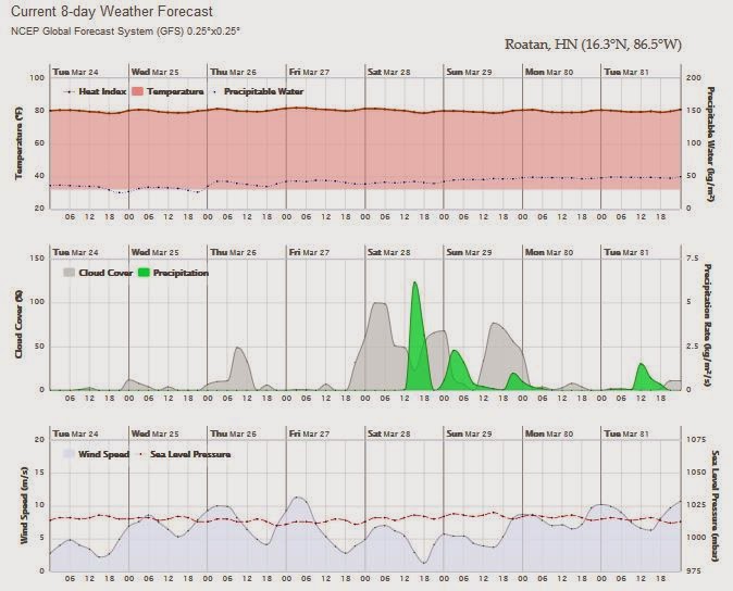
Skies will be mostly sunny. Winds will be light and variable in direction at 5 mph to 10 mph this morning; increasing to 10 mph to 20 mph this afternoon and evening. Seas will be calm to choppy at 1 to 4 feet.
The air temperatures will range from the low to high 70s (ºF) to the low 80s (ºF) or 23C to 27ºC. Ocean water temperatures are 76°F to 79°F or 24ºC to 26ºC. Visibility is 20 to 80 ft.
Ocean
water temperatures are 82°F to 84°F or 24ºC to 25ºC. Visibility
is 20 to 80 ft.


 |
|
Fig 20 - Recent changes in the
Saharan Air Layer
|
 |
The Tropical Weather Outlook
For the North Atlantic...Caribbean Sea and the Gulf of Mexico:
1. A weak front from Fort Myers, Florida to near Coatzacoalcos, Mexico will dissipate from Marco Island, Florida to the Yucatan Peninsula tonight. A new cold front will move across the NW Gulf of Mexico waters on Thu and reach from the western Florida panhandle to near Tuxpan, Mexico Thu night...and from Fort Myers, Florida to the Yucatan Peninsula Fri night before moving E of the area Sat. Near gale conditions are possible near the coast over the SW Gulf of Mexico Fri and Fri night.
2. Fresh easterly winds across the Gulf of Honduras will return Wed night and briefly become fresh to strong Fri morning.


Fig 23 - 48 Hour Tropical Storm Probability
high tide 12:38 am LT Sunrise – 5:49 am LT >88° SE
low tide 6:27 am LT Sunset – 5:59 pm LT <272° W
high tide 12:17 pm LT Moon Rise – 9:22 am LT >73° E
low tide 7:07 pm LT Moon Set – 10:26 pm LT <288° W
Daylight Hours: 12 hours, 10 minutes (+53 s)
low tide 6:27 am LT Sunset – 5:59 pm LT <272° W
high tide 12:17 pm LT Moon Rise – 9:22 am LT >73° E
low tide 7:07 pm LT Moon Set – 10:26 pm LT <288° W
Daylight Hours: 12 hours, 10 minutes (+53 s)

No comments:
Post a Comment