Tuesday, August 30, 2016

Partly Cloudy

The CoCoView Resort Weather Forecast
This weather forecast is intended for CoCoView Resort guests and applies only to the south side of Roatan
CoCoView is at 16.4°N Latitude x 86.4°W Longitude
in the
   NW Caribbean Sea

             CoCoView Resort, www.cocoviewresort.com , 800-510-8164


Tuesday, August 30, 2016
Skies will be partly cloudy.  Winds will be variable in direction at 5 mph to 10 mph or less. Seas will be  calm at 1 to 3 ft or less.  The air temperatures will range from the high 70sºF to the mid to high 80s ºF or 26°C to 27ºC. Ocean water temperatures are 80°F to 82°F or 26ºC to 27ºC.


The Tropical Weather Outlook
For the North Atlantic...Caribbean Sea and the Gulf of Mexico:1. Gulf of Mexico - Tropical Depression Nine centered near 23.8N 86.6W 1003 mb at 0900 UTC Aug 30 moving W or 275 deg at 6 kt. Maximum sustained winds 30 kt gusts 40 kt. The depression is expected to intensify to a tropical storm later today near 24.2N 87.3W. The cyclone will be located near 24.9N 87.6W early wed...near 26.2N 86.9W Wed evening...then begin to turn N and NE and intensify to 55 kt gusts 65 kt near 27.7N 85.5W early Thu. Numerous squalls and scattered tstms will spread from the SE Gulf N and NW into the E Gulf through Thu. The storm is expected to accelerate ne and move across northern Florida Thu night.
2. Caribbean Sea - High pressure building N and NE of the area will support fresh to strong trades in the south central Caribbean through Fri...with moderate trades expected elsewhere. A strong tropical wave in the eastern Atlantic will reach the tropical N Atlantic Sat...with high winds and seas possible N of 15N.
3. ...Special Features...
3a. Hurricane Gaston is centered near 32.0N 54.0W at 30/0900 UTC or about 550 nm east of Bermuda and about 1370 nm west of the Azores moving northeast at 5 kt. Estimated minimum central pressure is 971 mb. Maximum sustained wind speed is 85 kt with gusts to 105 kt. Scattered to numerous moderate convection is from 29N-34N between 51W-56W.
3b. Tropical Depression Eight is centered near 33.9N 75.0W at 30/0900 UTC or about 80 nm southeast of Cape Hatteras North Carolina moving northwest at 5 kt. Estimated minimum central pressure is 1010 mb. Maximum sustained wind speed is 30 kt with gusts to 40 kt. Scattered moderate convection is observed from 32N-35N between 72W and 75W.
3b. Tropical Depression Nine is centered near 23.8N 86.6W at 30/0900 UTC or about 270 nm west of Key West Florida and about 235 nm west-northwest of Havana Cuba moving west at 6 kt. Estimated minimum central pressure is 1003 mb. Maximum sustained wind speed is 30 kt with gusts to 40 kt. Numerous strong convection is observed from 21N-26N between 84W-87W.
4. ...Tropical Waves...
4a. A tropical wave is analyzed from 09N35W to 18N35W moving west at 15 to 20 kt. The tropical wave is well represented on animated precipitable water imagery and GOES high density winds for the lower and mid levels of the atmosphere. Aside from mid level cloudiness, no significant sensible weather is associated with this tropical wave and minimal amplification at the surface. Global models indicate the tropical wave will continue west although remain fairly weak at the surface, possible bringing a few showers into the Leeward and Windward Islands by Thursday.
4b. A tropical wave emerging off the African coast reaches from 08N19W to 1008 mb low pressure near 16N20W to 18N19W. The gradient between the tropical wave and high pressure to the north is enhancing northeast flow across the Canary Islands. Scattered moderate showers and thunderstorms are evident off the coast of Senegal, Gambia and Guinea-Bissau. The tropical wave is expected to stay intact as it tracks westward across the Atlantic over the next several days, accompanied by areas of fresh to strong winds and scattered showers and thunderstorms.
Fig 3 - Recent changes in the Saharan Air Layer
The Tides: Moon and Sun
low tide  1:24 am LT                                      Sunrise – 5:34 am LT>81° East
high tide 7:24 am LT                                      Sunset – 6:01 pm LT < 279° NW
low tide 1:34 pm LT                                       Moon Rise – 03:59 pm LT<75° East
high tide 7:45 pm LT                                      Moon Set – 04:55 am LT>283º West
                                                                                                                                        
Fig 4 - Moon

Day Light Hours:  12 hours, 26 minutes (-50s)

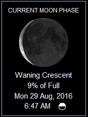
Monday, August 29, 2016

Again Mostly Cloudy

The CoCoView Resort Weather Forecast
This weather forecast is intended for CoCoView Resort guests and applies only to the south side of Roatan
CoCoView is at 16.4°N Latitude x 86.4°W Longitude
in the
   NW Caribbean Sea

             CoCoView Resort, www.cocoviewresort.com , 800-510-8164


Monday, August 29, 2016
Skies will be mostly cloudy. There is a slight chance of scattered rain showers. Winds will be westerly in direction at 5 mph to 10 mph or less. Seas will be  calm at 1 to 3 ft or less.  The air temperatures will range from the high 70sºF to the mid to high 80s ºF or 26°C to 27ºC. Ocean water temperatures are 80°F to 82°F or 26ºC to 27ºC.


The Tropical Weather Outlook
For the North Atlantic...Caribbean Sea and the Gulf of Mexico:1. Gulf of Mexico - Poorly organized tropical depression Nine in the SE Gulf centered near 23.5N 83.9W at 0900 UTC moving W or 270 deg at 8 kt. Maximum sustained winds 30 kt gusts 40 kt. It is expected to slowly intensify in the eastern Gulf during the next 2-3 days then turn northward and recurve across northern Florida Thu and Fri as a tropical storm.
2. Caribbean Sea - Fresh to strong trades are expected to develop later today in the S central Caribbean then persist through Thu...with moderate trades expected elsewhere.
3. ...Special Features...
3a. Hurricane Gaston remains nearly stationary near 30.8N 55.2W at 29/0900 UTC or about 515 nm east of Bermuda. Estimated minimum central pressure is 960 mb. Maximum sustained wind speed is 100 kt with gusts to 120 kt. Scattered to numerous moderate to strong convection is from 29N-32N between 53W-56W.
3b. Tropical Depression Eight is centered near 32.6N 73.0W at 29/0900 UTC or about 200 nm southeast of Cape Hatteras North Carolina moving west-northwest at 9 kt. Estimated minimum central pressure is 1010 mb. Maximum sustained wind speed is 30 kt with gusts to 40 kt. Scattered moderate convection is noted within 90 nm in the southwest quadrant of T.D. Eight.
3c. Tropical Depression Nine is centered near 23.5N 83.9W at 29/0900 UTC or about 85 nm west-northwest of Havana Cuba and about 135 nm west-southwest of Key West Florida moving west at 8 kt. Estimated minimum central pressure is 1007 mb. Maximum sustained wind speed is 30 kt with gusts to 40 kt. Scattered moderate and isolated strong convection is from 21N-23N between 82W-84W.

Fig 3 - Recent changes in the Saharan Air Layer
The Tides: Moon and Sun
low tide  12:49 am LT                                    Sunrise – 5:34 am LT>80° East
high tide 6:41 am LT                                      Sunset – 6:01 pm LT < 280° NW
low tide 1:00 pm LT                                       Moon Rise – 03:04 pm LT<73° East
high tide 7:14 pm LT                                      Moon Set – 04:08 am LT>286º West
                                                    
Fig 4 - Moon

Sunday, August 28, 2016

Mostly Cloudy


The CoCoView Resort Weather Forecast
This weather forecast is intended for CoCoView Resort guests and applies only to the south side of Roatan
CoCoView is at 16.4°N Latitude x 86.4°W Longitude
in the
   NW Caribbean Sea

             CoCoView Resort, www.cocoviewresort.com , 800-510-8164


Sunday, August 28, 2016
Skies will be mostly cloudy. There is a slight chance of scattered rain showers. Winds will be westerly in direction at 5 mph to 10 mph or less. Seas will be  calm at 1 to 3 ft or less.  The air temperatures will range from the high 70sºF to the mid to high 80s ºF or 26°C to 27ºC. Ocean water temperatures are 80°F to 82°F or 26ºC to 27ºC.


The Tropical Weather Outlook
For the North Atlantic...Caribbean Sea and the Gulf of Mexico:1. Gulf of Mexico - Weak ridge N of the area will support gentle to moderate E winds and 2 to 4 ft seas across most of the basin through Mon. An area of low pressure will move into the SE Gulf tonight...and may become a tropical depression in the E Gulf and turn N toward Big Bend of Florida during the next 3 to 4 days.
2. Caribbean Sea - Long period swell generated by Hurricane Gaston will propagate into the tropical waters N of 16N E of 60W through Mon. Gentle to moderate trade winds will prevail across most of the area through Mon. Fresh to strong trades developing over the S central Caribbean Mon night will persist through Thu.
3. ...Special Features...
3a. Hurricane Gaston is centered near 30.1N 54.6W at 28/0900 UTC or about 540 nm east of Bermuda moving northwest at 5 kt. Estimated minimum central pressure is 975 mb. Maximum sustained wind speed is 80 kt with gusts to 100 kt. Scattered moderate to isolated strong convection is within 60/75 nm of a line from 29N56W to 31N52W. Scattered showers and isolated thunderstorms are within 30/45 nm of a line from 27N57W to 30N53W.
3b. A 1009 mb low pressure is off the coast of Cuba near 24N80W with a surface trough extending from 26N79W through the low then across Cuba to 21N83W. Scattered moderate to isolated strong convection is from Andros Island to Cuba between 78W-80W. Scattered showers and isolated thunderstorms are from 19N-26N between 76W-81W and from 21N-25N between 81W-86W. This system has a medium chance of of tropical development over the next 48 hours. Upper-level winds are not conducive for significant development today while this system moves westward through the Straits of Florida. Environmental conditions are forecast to become a little more conducive when the low moves into the southeastern Gulf of Mexico on Monday. Regardless of development, gusty winds and locally heavy rainfall are likely over portions of the central and northwestern Bahamas and Cuba through tonight. These winds and rains will spread into parts of southern Florida and the Florida Keys later today. Shower and thunderstorm activity has increased during the past few hours in association with an area of low pressure located about 250 miles west of Bermuda centered near 31N69W. While environmental conditions are only marginally conducive, some additional development of this system is possible during the next day or so while it moves west-northwestward at about 10 kt. As the low approaches the coast of North Carolina by mid-week, conditions are expected to become unfavorable for further development. This system has a medium chance of of tropical development over the next 48 hours.
4...Tropical Waves...
4a. Tropical wave in the east Tropical Atlantic extends from 15N33W to 10N35W moving west near 15 kt over the past 24 hours. Wave is embedded within an area of dry stable air, thus no associated showers or convection.
4b. Tropical wave in the W Caribbean extends along 86W south of 20N to inland over Central America moving west near 10 kt over past 24 hours. Wave is embedded within an area of deep moisture. Scattered showers and possible isolated thunderstorms are from 18N to inland over Central America between 84W-87W.

Fig 3 - Recent changes in the Saharan Air Layer
The Tides: Moon and Sun 
low tide  12:10 am LT                                    Sunrise – 5:34 am LT>80° East
high tide 5:54 am LT                                      Sunset – 6:02 pm LT < 280° NW
low tide 12:21 pm LT                                     Moon Rise – 02:08 pm LT<71° East
high tide 6:41 pm LT                                      Moon Set – 03:17 am LT>288º West
                                                                                                                                        
Fig 4 - Moon

Day Light Hours:  12 hours, 28 minutes (-50s)

Saturday, August 27, 2016

Mostly Cloudy

The CoCoView Resort Weather Forecast
This weather forecast is intended for CoCoView Resort guests and applies only to the south side of Roatan
CoCoView is at 16.4°N Latitude x 86.4°W Longitude
in the
   NW Caribbean Sea

             CoCoView Resort, www.cocoviewresort.com , 800-510-8164


Saturday, August 27, 2016
Skies will be mostly cloudy. There is a very slight chance of scattered rain showers. Winds will be westerly in direction at 5 mph to 10 mph or less. Seas will be  calm at 1 to 3 ft or less.  The air temperatures will range from the high 70sºF to the mid to high 80s ºF or 26°C to 27ºC. Ocean water temperatures are 80°F to 82°F or 26ºC to 27ºC.


The Tropical Weather Outlook
For the North Atlantic...Caribbean Sea and the Gulf of Mexico:
1. Gulf of Mexico - Weak ridging N of the area will support gentle to moderate E to NE winds and 2 to 4 ft seas across the region through sun. A weak disturbance moving into the SE Gulf Sun will weaken into a trough across the central Gulf through tue.
2. Caribbean Sea - Long period swell generated by Tropical Storm Gaston will propagate into the tropical waters N of 18N E of 57W today. Gentle to moderate trade winds will prevail across most of the area this weekend. Fresh to strong trades will develop over the S central Caribbean early next week.
3. ...Special Features...
3a. Tropical Storm Gaston is centered near 27.9N 52.0W at 27/0900 UTC or about 715 nm east-southeast of Bermuda moving northwest at 13 kt. Estimated minimum central pressure is 995 mb. Maximum sustained wind speed is 55 kt with gusts to 65 kt. Scattered moderate to isolated strong convection is from 27N-31N between 49W-55W.
4...Tropical Waves...
4a. Tropical wave in the east Tropical Atlantic extends along 27W from 10N-15N moving west near 10 kt over the past 24 hours. Wave is embedded within an area of dry stable air, thus no associated showers or convection.
4b. Tropical wave in the W Caribbean extends from 20N80W to 11N83W moving west 10 to 15 over past 24 hours. Wave coincides with a well defined 700 mb global model trough and is embedded within an area of deep moisture. Scattered showers and isolated thunderstorms are from 19N to the coast of Central America between the wave and 88W.
Fig 3 - Recent changes in the Saharan Air Layer
The Tides: Moon and Sun
high tide 5:02 am LT                                        Sunrise – 5:34 am LT>80° East
low tide 11:37 am LT                                       Sunset – 6:03 pm LT < 280° NW
high tide 6:03 pm LT                                        Moon Rise – 01:12 pm LT<71° East
low tide  12:10 am LT                                      Moon Set – 02:24 am LT>289º West
  

Fig 4 - Moon

Day Light Hours:  12 hours, 29 minutes (-49s)

Friday, August 26, 2016

Partly Sunny

The CoCoView Resort Weather Forecast
This weather forecast is intended for CoCoView Resort guests and applies only to the south side of Roatan
CoCoView is at 16.4°N Latitude x 86.4°W Longitude
in the
   NW Caribbean Sea

             CoCoView Resort, www.cocoviewresort.com , 800-510-8164


Friday, August 26, 2016
Skies will be partly sunny. Winds will be westerly in direction at 5 mph to 10 mph or less. Seas will be  calm at 1 to 3 ft or less.  The air temperatures will range from the high 70sºF to the mid to high 80s ºF or 26°C to 27ºC. Ocean water temperatures are 80°F to 82°F or 26ºC to 27ºC.


The Tropical Weather Outlook
For the North Atlantic...Caribbean Sea and the Gulf of Mexico:
1. Gulf of Mexico - A ridge over the northern Gulf coast will maintain gentle to moderate winds across the area through Sat night. A tropical low...possible tropical cyclone...could move into the eastern Gulf on Sun or Mon and cause winds and seas in this area to increase.
2. Caribbean Sea - Long period swell generated by Tropical Storm Gaston will propagate into the tropical waters N of 18N E of 57W Fri. A relatively small difference in pressure between a ridge to the N and low pressure over South America will maintain gentle to moderate trade winds across most of the area through the weekend. Heavy rainfall will be possible over the Greater Antilles through Sat.
3. Special Features...
Tropical Storm Gaston is centered near 23.9N 47.6W at 26/0900 UTC or about 980 nm east-northeast of the Leeward Islands and about 1140 nm east-southeast of Bermuda moving northwest at 15 kt. Estimated minimum central pressure is 997 mb. Maximum sustained wind speed is 55 kt with gusts to 65 kt. Scattered moderate to isolated strong convection is from 23N-26N between 41W-48W.
4. TROPICAL WAVES...
4a. Tropical wave in the far east Tropical Atlantic extends along 22W/23W from 8N-17N with a weak 1009 mb low along the wave near 13N. The wave/low is moving west-southwest near 10 kt over the past 12 hours. Wave is embedded within an area of dry stable air, thus no associated showers or convection.
4b. Tropical wave in the southwest Atlantic/north Caribbean extends from 26N72W through a weak 1009 mb low near 21N75W to 17N76W moving west near 15 kt over the past 24 hours. Wave coincides with a well defined 700 mb global model trough and is embedded within an area of deep moisture. Scattered showers and isolated thunderstorms are south of 23N between 68W and the wave axis and from 23N-25N between 68W-70W.
Fig 3 - Recent changes in the Saharan Air Layer
The Tides: Moon and Sun
high tide 4:02 am LT                                        Sunrise – 5:34 am LT>79° East
low tide 10:46 am LT                                       Sunset – 6:04 pm LT < 281° NW
high tide 5:22 pm LT                                        Moon Rise – 12:18 pm LT<72° East
low tide  11:26 pm LT                                      Moon Set – 01:28 am LT>289º West
                                                    
Fig 4 - Moon

Day Light Hours:  12 hours, 29 minutes (-49s)

Thursday, August 25, 2016

Skies will be sunny

The CoCoView Resort Weather Forecast
This weather forecast is intended for CoCoView Resort guests and applies only to the south side of Roatan
CoCoView is at 16.4°N Latitude x 86.4°W Longitude
in the
   NW Caribbean Sea

             CoCoView Resort, www.cocoviewresort.com , 800-510-8164


Thursday, August 25, 2016
Skies will be sunny. Winds will be westerly in direction at 5 mph to 10 mph or less. Seas will be  calm at 1 to 3 ft or less.  The air temperatures will range from the high 70sºF to the mid to high 80s ºF or 26°C to 27ºC. Ocean water temperatures are 80°F to 82°F or 26ºC to 27ºC.


The Tropical Weather Outlook
For the North Atlantic...Caribbean Sea and the Gulf of Mexico:
1. Gulf of Mexico - A ridge over the northern Gulf coast will maintain gentle to moderate winds across the area through Sat. A tropical low is expected to move into the eastern Gulf Sun and Mon. The winds and seas associated with this low remain very uncertain.
2. Caribbean Sea - A weak pressure gradient will maintain gentle to moderate trade winds across most of the area through the weekend. Long period swell generated by Hurricane Gaston will propagate into the tropical waters N of 18N E of 57W Fri.
3.Hurricane Gaston is centered near 19.5N 43.3W at 25/0900 UTC or about 1065 nm east of the Leeward Islands moving northwest at 15 kt. Estimated minimum central pressure is 988 mb. Maximum sustained wind speed is 65 kt with gusts to 80 kt. Scattered moderate to isolated strong convection is from 18N-24N between 39W-45W.
4. Gale Warning for Southwest Atlantic... A Gale warning has been issued for the area northeast of a broad area of low pressure analyzed as a 1008 mb low north of Hispaniola near 21N68.5W. These winds are expected to continue for the next 24 hours. Scattered moderate to isolated strong convection is from 17N-21N between 66W-69W including portions of Puerto Rico and the Mona Passage, and from 17N to over Hispaniola between 69W-73W. Environmental conditions have the potential to become more conducive for tropical development over the weekend when the system is near the central or northwestern Bahamas. Regardless of development, gusty winds, heavy rains, and possible flash floods and mudslides are likely to occur over portions of Puerto Rico, the Turks and Caicos, Hispaniola, and the southeastern and central Bahamas during the next couple of days. There is a medium chance of tropical development in the next 48 hours.
Fig 3 - Recent changes in the Saharan Air Layer
The Tides: Moon and Sun 
high tide 2:51 am LT                                        Sunrise – 5:34 am LT>79° East
low tide 9:42 am LT                                         Sunset – 6:04 pm LT < 281° NW
high tide 4:30 pm LT                                        Moon Rise – 12:17 pm LT<74° East
low tide  10:33 pm LT                                      Moon Set – 12:30 am LT>288º West
                                                                                                                                     

Fig 4 - Moon

Day Light Hours:  12 hours, 30 minutes (-49s)

Wednesday, August 24, 2016

Again Partly Cloudy

The CoCoView Resort Weather Forecast
This weather forecast is intended for CoCoView Resort guests and applies only to the south side of Roatan
CoCoView is at 16.4°N Latitude x 86.4°W Longitude
in the
   NW Caribbean Sea

             CoCoView Resort, www.cocoviewresort.com , 800-510-8164


Wednesday, August 24, 2016
Skies will be partly cloudy. Winds will be easterly in direction at 5 mph to 10 mph or less. Seas will be  calm at 1 to 3 ft or less.  The air temperatures will range from the high 70sºF to the mid to high 80s ºF or 26°C to 27ºC. Ocean water temperatures are 80°F to 82°F or 26ºC to 27ºC.


The Tropical Weather Outlook
For the North Atlantic...Caribbean Sea and the Gulf of Mexico:
1. Gulf of Mexico - A thermal trough will develop over the Yucatan Peninsula during the late afternoons. A surface high currently over the N central Gulf will shift N of the area today with the pressure gradient tightening across the NE Gulf waters briefly tonight.
2. Caribbean Sea - A tropical low is currently near 17N61W along a tropical wave axis. Tropical cyclone development is possible as the low continues NW across the Leewards today with the strongest winds over the NE quadrant of the low. Fresh trades will develop across the E and central Caribbean tonight and continue through Sat. Strong NE winds expected along the NW coast of Colombia tonight. Tropical cyclone Gaston is expected to pass E of the area...but long period swells resulting in combined seas of 7-9 ft will propagate into the tropical waters N of 18N E of 57W on Fri.
3. ...SPECIAL FEATURES...
3a. Tropical Storm Gaston is centered near 14.9N 38.6W at 24/0900 UTC or about 850 nm west of the Cabo Verde Islands moving west- northwest at 15 kt. Estimated minimum central pressure is 999 mb. Maximum sustained wind speed is 60 kt with gusts to 75 kt. Scattered moderate to isolated strong convection is from 13N-17N between 35W-40W. Clusters of scattered moderate convection are from 15N-20N between 39W-43W.
3b. A tropical wave moving across the Lesser Antilles is analyzed from 21N66W along 18N63W through a 1009 mb low near 17N61W to 12N59W. This system could become a tropical depression during the next day or two as it moves west-northwest 13 to 17 kt. Conditions could become more conducive later this week while the system moves near the southeastern and central Bahamas. Scattered moderate to isolated strong convection is from 15N-18N between 60W-64W. Scattered showers and possible isolated thunderstorms are from 17N-21N between 56W-67W. There is a medium chance of tropical formation in the next 48 hours. Interests from the islands of the northeastern Caribbean Sea to the Bahamas should continue to monitor the progress of this system. Gusty winds, heavy rains, and possible flash floods and mud slides could occur over portions of these areas regardless of tropical cyclone formation.
Fig 3 - Recent changes in the Saharan Air Layer
The Tides: Moon and Sun
high tide 1:26 am LT                                        Sunrise – 5:33 am LT>78° East
low tide 8:26 am LT                                         Sunset – 6:05 pm LT < 281° NW
high tide 3:26 pm LT                                        Moon Rise – 11:23 pm LT<74° East
low tide  9:21 pm LT                                        Moon Set – 11:31 am LT>285º West
                                                                                                                                       
Fig 4 - Moon

Tuesday, August 23, 2016

Partly Cloudy

The CoCoView Resort Weather Forecast
This weather forecast is intended for CoCoView Resort guests and applies only to the south side of Roatan
CoCoView is at 16.4°N Latitude x 86.4°W Longitude
in the
   NW Caribbean Sea

             CoCoView Resort, www.cocoviewresort.com , 800-510-8164


Tuesday, August 23, 2016
Skies will be partly cloudy. Winds will be easterly in direction at 10 mph to 15 mph. Seas will be  moderate at 2 to 4 ft or less.  The air temperatures will range from the high 70sºF to the mid to high 80s ºF or 26°C to 27ºC. Ocean water temperatures are 80°F to 82°F or 26ºC to 27ºC.


The Tropical Weather Outlook
For the North Atlantic...Caribbean Sea and the Gulf of Mexico:1. Gulf of Mexico - A tropical wave will pass W through the Bay of Campeche today. A thermal trough will develop over the Yucatan Peninsula during the late afternoons and continue into the early evenings. The trough will lose identity near 22N94W by late each morning. A surface high over the N central Gulf will shift N of the area on Wed leaving a NE to SW ridge ac0ross the northern Gulf waters on Thu and fri.
2. Caribbean Sea - Strong NE trades will continue along the NW coast of Colombia this morning and develop again tonight. A tropical low is currently near 16.5N 55.5W along a tropical wave. The low and wave will track nw across the NE Caribbean passing near the Virgin Islands tonight...and passing N of Puerto Rico on Wed... with the strongest winds over the NE quadrant. The low may develop into a tropical cyclone. Tropical cyclone Gaston is expected to pass E of the area...but long period swells resulting in combined seas of 7-10 ft will propagate into the tropical waters N of 15N E of 60W on Fri and Sat.
3....Special Features...
3a. Tropical Depression Fiona is centered near 25.8N 63.4W at 23/0900 UTC or about 456 nm north of the northern Leeward Islands, moving west-northwest at 11 kt. Estimated minimum central pressure is 1010 mb. Maximum sustained wind speed is 30 kt with gusts to 40kt. Scattered showers and isolated tstms are from 24N to 26N between 61W and 64W.
3b. Tropical Storm Gaston is centered near 13.2N 32.4W at 23/0900 UTC or about 474 nm west of the southernmost Cabo Verde Islands, moving west at 17 kt. Estimated minimum central pressure is 1004 mb. Maximum sustained wind speed is 45 kt with gusts to 55 kt. Scattered showers are from 10N to 16N between 30W and 35W.
3c. A tropical wave is located about 348 nm east-southeast of the Leeward Islands extending from 11N to 21N with axis near 55W. The wave is associated with a 1009 mb low located near 16N55W and has been moving west-northwest at 15-20 kt within the last 24 hours. Moisture has increased in the wave environment, which along with favorable deep layer wind shear and upper level diffluence support heavy showers and isolated tstms from 13N to 20N between 53W and 58W. Large-scale conditions could become more conducive later this week while the system moves near Hispaniola and then the southeastern and central Bahamas. Despite of any tropical development, gusty winds, heavy rains, and possible flash floods and mud slides could occur over these areas. This system has a medium chance for tropical formation within the next 48 hours.
Fig 3 - Recent changes in the Saharan Air Layer
The Tides: Moon and Sun
low tide 7:05 am LT                                         Sunrise – 5:33 am LT>78° East
high tide 2:04 pm LT                                        Sunset – 6:06 pm LT < 282° NW
low tide  7:48 pm LT                                        Moon Rise – 10:32 pm LT<77° East
high tide 1:26 am LT                                        Moon Set – 10:31 am LT>281º West
                                                                                                                                         
Fig 4 - Moon

Day Light Hours:  12 hours, 33 minutes (-48s)

Monday, August 22, 2016

Mostly Clooudy

The CoCoView Resort Weather Forecast
This weather forecast is intended for CoCoView Resort guests and applies only to the south side of Roatan
CoCoView is at 16.4°N Latitude x 86.4°W Longitude
in the
   NW Caribbean Sea

             CoCoView Resort, www.cocoviewresort.com , 800-510-8164


Monday, August 22, 2016
Skies will be mostly cloudy. Winds will be easterly in direction at 10 mph to 30 mph. Seas will be  moderate to rough  at 2 to 4 ft or higher. Divers should exercise caution exiting and entering the boats, especially on the afternoon dives. The air temperatures will range from the high 70sºF to the mid to high 80s ºF or 26°C to 27ºC. Ocean water temperatures are 80°F to 82°F or 26ºC to 27ºC.


The Tropical Weather Outlook
For the North Atlantic...Caribbean Sea and the Gulf of Mexico:
1. Gulf of Mexico - A recurring surface trough will support fresh to strong NE to E winds along the NW coast of the Yucatan Peninsula and across the E Bay of Campeche tonight...with fresh conditions expected to develop each evening through Wed evening. A surface high over the E central Gulf will shift NW reaching near the Mississippi Delta on Tue...then shift N of the area on Wed leaving a NE to SW ridge across the northern Gulf waters on Thu with the ridge weakening on Fri.
2. Caribbean Sea - A tropical wave along 78W will move through the W Caribbean through Tue night. Strong trades across the S central Caribbean will diminish beginning Wed night. A tropical wave is along 48W with a low along wave near 15N48W. This system will reach along 55W late tonight and pass W NW through the tropical waters E of the Lesser Antilles on Tue into early Wed when it will reach the Virgin Island area. Conditions may become favorable for tropical cyclone development in 3-5 days.
3. Tropical depression Fiona is centered near 24.4N 58.4W at 22/0900 UTC or about 456 nm northeast of the northern Leeward Islands, moving west-northwest at 16 kt. Estimated minimum central pressure is 1008 mb. Maximum sustained wind speed is 30 kt with gusts to 40 kt. Scattered heavy showers and isolated tstms are from 22N to 26N between 54W and 58W.
4. ...TROPICAL WAVES...
4a. A tropical wave is in the east Atlantic extending from 06N-16N with axis near 24W, moving west at 15 kt within the last 24 hours. The wave is associated with a 1008 mb low that is centered near 11N24W. Abundant moisture in the wave environment, favorable deep layer wind shear and middle to upper level diffluence favor numerous heavy showers and isolated tstms from 09N to 15N between 25W and 28W. Scattered heavy showers are from 05N to 09N between 22W and 37W. Environmental conditions are conducive for development, and a tropical depression is likely to form later today while the system moves westward to west-northwestward over the eastern tropical Atlantic Ocean.
4b. Tropical wave is in the central Atlantic extending from 08N-19N with axis near 47W, moving W at 15-20 kt within the last 24 hours. There is a 1010 mb low near 14N47W associated with the wave. Saharan dry air and dust in the wave environment limit the convection to scattered showers and tstms from 14N to 18N between 44W and 52W. Dry air near this system is expected to inhibit significant development during the next few days while the disturbance moves westward to west-northwestward. Environmental conditions could become more conducive for development late this week when the system is expected to move near Hispaniola and the southeastern and central Bahamas.
4c. Tropical wave is in the western Caribbean extending from 10N to 21N with axis near 80W, moving west at 15 kt within the last 24 hours. CIRA LPW imagery from the surface to 850 mb show large patches of dry air in the wave environment mainly east of the wave axis. Water vapor imagery continue to show strong dry air subsidence across this region of the Caribbean. This results in a tropical wave devoid of convection at this time.

Fig 3 - Recent changes in the Saharan Air Layer
The Tides: Moon and Sun
low tide 5:40 am LT                                           Sunrise – 5:33 am LT>78° East
high tide 12:32 pm LT                                        Sunset – 6:06 pm LT < 282° NW
low tide  6:17 pm LT                                          Moon Rise – 9:42 pm LT<81° East
high tide 11:57 pm LT                                        Moon Set – 9:33 am LT>277º West

Fig 4 - Moon

Day Light Hours:  12 hours, 33 minutes (-48s)

Sunday, August 21, 2016

Partly Sunny

The CoCoView Resort Weather Forecast
This weather forecast is intended for CoCoView Resort guests and applies only to the south side of Roatan
CoCoView is at 16.4°N Latitude x 86.4°W Longitude
in the
   NW Caribbean Sea

             CoCoView Resort, www.cocoviewresort.com , 800-510-8164


Sunday, August 21, 2016
Skies will be partly sunny. Winds will be easterly in direction at 10 mph to 30 mph. Seas will be  moderate to rough  at 2 to 4 ft or higher. Divers should exercise caution exiting and entering the boats, especially on the afternoon dives. The air temperatures will range from the high 70sºF to the mid to high 80s ºF or 26°C to 27ºC. Ocean water temperatures are 80°F to 82°F or 26ºC to 27ºC.


The Tropical Weather Outlook
For the North Atlantic...Caribbean Sea and the Gulf of Mexico:1. Gulf of Mexico - A recurring surface trough will support strong NE to E winds along the NW coast of the Yucatan Peninsula and across the E Bay of Campeche tonight and Mon night with fresh conditions expected the remainder of the period. A surface high over the E central Gulf will shift NW reaching near the Mississippi Delta on Tue...then shift N of the area on Wed and Thu leaving an E to W ridge across the northern Gulf waters.
2. Caribbean Sea - A tropical wave currently along 72W will move W through the central Caribbean today and pass through the W Caribbean tonight through Tue night. Strong trades across the S central Caribbean will diminish some on Tue. A tropical low currently near 13N41W will pass W through the tropical waters E of the Lesser Antilles on Tue with conditions becoming more favorable for tropical cyclone development in 3 to 5 days.
3. At 500 AM AST (0900 UTC), the center of Tropical Storm Fiona was located near latitude 22.2 North, longitude 51.7 West. Fiona is moving toward the west-northwest near 16 mph (26 km/h) and this general motion is expected to continue during the next couple of days. 4. Tropical Waves...
4a. Tropical wave is just off the west coast of Africa extending from 06N-19N with axis near 18W. There is a 1009 mb low near 12N18W associated with the wave, which is expected to move at 10-15 kt within the next 24 hours. The wave is within a moderate moist environment and it is in a region of favorable to neutral deep layer wind shear that favors scattered heavy showers and isolated tstms from 06N-15N E of 22W. Environmental conditions appear conducive for gradual development, and a tropical depression is likely to form in a few days while the system moves westward and then northwestward over the eastern tropical Atlantic Ocean.
4b. Tropical wave is in the central Atlantic extending from 07N-18N with axis near 41W, moving W at 15-20 kt within the last 24 hours. There is a 1009 mb low near 13N41W associated with the wave. Intrusion of Saharan dry air and dust to the wave environment continue to limit the convection to scattered showers from 12N-18N between 37W and 45W. Environmental conditions are forecast to be conducive for development, and a tropical depression could form within the next few days while the system moves westward and then west-northwestward across the tropical Atlantic Ocean, through the eastern Caribbean Sea, and then near the Greater Antilles.
4c. Tropical wave in the central Caribbean extends from 10N-20N with axis near 72W, moving W at 10 kt within the last 24 hours. Even though the wave is in a region of favorable to neutral deep layer wind shear, strong dry air subsidence from aloft inhibits convection at the time.
Fig 3 - Recent changes in the Saharan Air Layer
The Tides: Moon and Sun
low tide 4:45 am LT                                           Sunrise – 5:33 am LT>77° East
high tide 11:05 am LT                                        Sunset – 6:07 pm LT < 282° NW
low tide  5:02 pm LT                                          Moon Rise – 8:54 pm LT<85° East
high tide 10:48 pm LT                                        Moon Set – 8:34 am LT>272º West
Fig 4 - Moon

Day Light Hours:  12 hours, 34 minutes (-48s)