Monday, February 29, 2016

Mostly Sunny with Moderate East Winds

The CoCoView Resort Weather Forecast
This weather forecast is intended for CoCoView Resort guests and applies only to the south side of Roatan
CoCoView is at 16.4°N Latitude x 86.4°W Longitude
in the
   NW Caribbean Sea

             CoCoView Resort, www.cocoviewresort.com , 800-510-8164


Monday, February 29, 2016
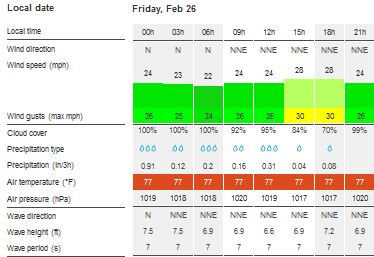
Skies will be mostly sunny. Winds will be easterly in direction at 10 mph or less. Seas will be calm to moderate at 1 ft to 4 ft.
The air temperatures will range from the low 70sºF to mid 80s ºF or 25°C to 27ºC. Ocean water temperatures are 78°F to 82°F or 25ºC to 27ºC.


The Tropical Weather Outlook
For the North Atlantic...Caribbean Sea and the Gulf of Mexico:
1. High pressure in the NE Gulf of Mexico will weaken and move E of the area Tue. Moderate return flow in the western Gulf will continue through Tue ahead of a cold front expected to move into the northern Gulf of Mexico Tue night. The front will extend from the Florida Big Bend to Brownsville,, Texas early on Wed...then weaken as it quickly moves E of the area Wed night. Another cold front will move into the northern Gulf  of Mexico Thu night and quickly move E of the basin by Fri night.
2. A weakening stationary front extends from northern Haiti SW to Jamaica and to the NE Honduras coast near 15N83W. The front will dissipate through this morning. Fresh to strong NE to E trades in the S central Caribbean will strengthen in the early morning hours through Thu. Moderate to fresh trades will prevail elsewhere across the region.
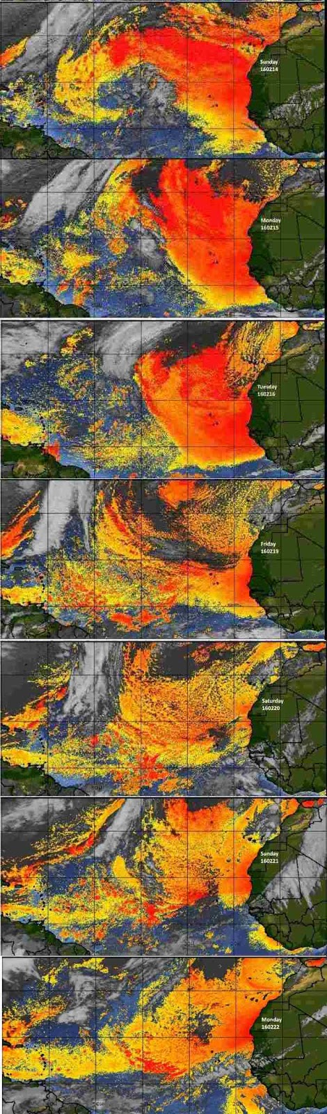
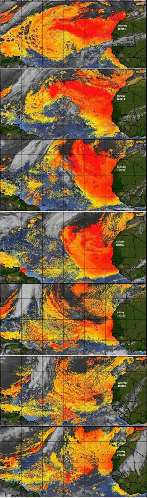
Fig 3 - Recent changes in the Saharan Air Layer
The Tides: Moon and Sun 
high tide 3:26 pm LT                                                          Sunrise – 6:05 am LT>98° East
low tide 8:27 am LT                                                           Sunset – 5:54 pm LT < 262° West
high tide 1:44 pm LT                                                          Moon Rise – 11:35 pm LT>106° East
low tide 8:42pm LT                                                            Moon Set – 10:35 am LT < 255° West

Fig 4 - Moon

Day Light Hours:  11 hours, 49 minutes (+51)

Sunday, February 28, 2016

Partly Sunny with Moderate Easterly Winds

The CoCoView Resort Weather Forecast
This weather forecast is intended for CoCoView Resort guests and applies only to the south side of Roatan
CoCoView is at 16.4°N Latitude x 86.4°W Longitude
in the
   NW Caribbean Sea

             CoCoView Resort, www.cocoviewresort.com , 800-510-8164


Sunday, February 28, 2016
Skies will be partly cloudy. There is a slight chance of rain through Tuesday. Winds will be easterly in direction at 15 mph to 20 mph. Seas will be moderate at 2 ft to 4 ft.
The air temperatures will range from the low 70sºF to mid 80s ºF or 25°C to 27ºC. Ocean water temperatures are 78°F to 82°F or 25ºC to 27ºC.


The Tropical Weather Outlook
For the North Atlantic...Caribbean Sea and the Gulf of Mexico:1. The Gulf of Mexico - High pressure in the NE Gulf will weaken and move E of the area Mon. Moderate return flow in the western Gulf will continue through Tue ahead of a cold front expected to move into the NW Gulf late Tue night. The front will extend from Apalachee Bay to the western Bay of Campeche Wed night...then weaken to a trough over the eastern Gulf on Thu. Another cold front will move into NW Gulf Thu night.
2. Fresh N to NE winds in the NW Caribbean W of a dissipating front that stretches from the Windward Passage SW to Jamaica to and to just E of southern Nicaragua will diminish tonight. Fresh to strong NE to E trades in the S central Caribbean will strengthen each night through Thu. Moderate to fresh trades will prevail elsewhere across the region.

Fig 3 - Recent changes in the Saharan Air Layer
he Tides: Moon and Sun
high tide 2:05 pm LT                                                          Sunrise – 6:05 am LT>98° East
low tide 7:05 am LT                                                           Sunset – 5:54 pm LT < 262° West
high tide 12:17 pm LT                                                        Moon Rise – 10:46 pm LT>104° East
low tide 7:28pm LT                                                            Moon Set – 9:53 am LT < 257° West

Fig 4 - Moon

Friday, February 26, 2016

Again Cloudy with Rain

The CoCoView Resort Weather Forecast
This weather forecast is intended for CoCoView Resort guests and applies only to the south side of Roatan
CoCoView is at 16.4°N Latitude x 86.4°W Longitude
in the
   NW Caribbean Sea

             CoCoView Resort, www.cocoviewresort.com , 800-510-8164


Friday, February 26, 2016
Skies will be mostly cloudy with rain. There is a very slight chance of rain through this weekend. Winds will be northerly in direction at 20 mph to 30 mph or higher. Seas will be moderate to rough at 1 ft to 4 ft or higher.
The air temperatures will range from the low 70sºF to mid 80s ºF or 25°C to 27ºC. Ocean water temperatures are 78°F to 82°F or 25ºC to 27ºC.


The Tropical Weather Outlook
For the North Atlantic...Caribbean Sea and the Gulf of Mexico:
1. High pressure in NW Gulf of Mexico will be reinforced by a high over the southern plains tonight...and move to the NE Gulf of Mexico by late Sat night. The high will weaken Sun through Tue. A weak frontal trough will sweep across the eastern and central waters through early this evening. Winds and seas in its wake will gradually diminish through tonight. Moderate to fresh southerly return flow is expected in the western Gulf of Mexico Sun through Tue.
2. A cold front from E central Cuba to NE Honduras will reach from the Windward Passage to the NE Honduras and Nicaragua border by early this evening and stall. The front will begin to weaken Sat and Sat night...eventually becoming diffuse Sun and Sun night. Fresh to strong winds in S Central Caribbean will strengthen during late night and early morning hours during the period. Moderate to fresh trades will prevail elsewhere through Tue.
Fig 3 - Recent changes in the Saharan Air Layer
The Tides: Moon and Sun
low tide 4:54 am LT                                                        Sunrise – 6:07 am LT>99° East
high tide 10:29 am LT                                                     Sunset – 5:54 pm LT < 261° West
low tide 5:16pm LT                                                        Moon Rise – 9:11 pm LT>98° East
high tide 12:34 pm LT                                                   Moon Set – 8:34 am LT < 264° West

Fig 4 - Moon

Day Light Hours:  11 hours, 47 minutes (+51)

Thursday, February 25, 2016

Mostly Cloudy with Rain

The CoCoView Resort Weather Forecast
This weather forecast is intended for CoCoView Resort guests and applies only to the south side of Roatan
CoCoView is at 16.4°N Latitude x 86.4°W Longitude
in the
   NW Caribbean Sea

             CoCoView Resort, www.cocoviewresort.com , 800-510-8164


Thursday, February 25, 2016
Skies will be mostly cloudy with rain. Expect rain through Friday. Winds will be northerly in direction at 10 mph to 30 mph or higher. Seas will be moderate to rough at 1 ft to 4 ft or higher.
The air temperatures will range from the low 70sºF to mid 80s ºF or 25°C to 27ºC. Ocean water temperatures are 78°F to 82°F or 25ºC to 27ºC.


The Tropical Weather Outlook
1. The strong cold front that was affecting the Gulf of Mexico with gale force winds and large seas has just move SE of the area. High pressure in the wake of the front centered over the NW Gulf of Mexico will be reinforced by a stronger high pressure tonight into early Fri. This will briefly support fresh to locally strong NW to N winds over the N central and NE waters. The high will slide E along the northern Gulf of Mexico coast through the weekend which will result in gradual veering of the winds to E-SE by Sunday.
2. A cold front has moved into the NW Caribbean and extends from western Cuba to the Gulf of Honduras. ( See Fig 3a below ) Fresh to strong northerly winds follow the front which is forecast to a reach a position from eastern Cuba to NE Honduras this evening...from the Windward Passage to near Cabo Gracias Adios Nicaragua by Friday evening...and from Hispaniola to the SW Caribbean near 11N83W by Sat evening...while gradually weakening.

Fig 3 - Recent changes in the Saharan Air Layer

Fig 3a - Cold Front Position
The Tides: Moon and Sun
low tide 4:09 am LT                                                      Sunrise – 6:07 am LT>99° East
high tide 9:57 am LT                                                     Sunset – 5:53 pm LT < 261° West
low tide 4:30 pm LT                                                      Moon Rise – 8:24 pm LT>94° East
high tide 11:17 pm LT                                                  Moon Set – 7:55 am LT < 268° West
Fig 4 - Moon

Day Light Hours: 11 hours, 46 minutes (+50)


Tuesday, February 23, 2016

Again Mostly Sunny

The CoCoView Resort Weather Forecast
This weather forecast is intended for CoCoView Resort guests and applies only to the south side of Roatan
CoCoView is at 16.4°N Latitude x 86.4°W Longitude
in the
   NW Caribbean Sea

             CoCoView Resort, www.cocoviewresort.com , 800-510-8164


Tuesday, February 23, 2016
Skies will be mostly sunny.  Winds will be  ESE to ENE in direction at 10 mph to 15 mph. Seas will be choppy at 2 ft to 4 ft.
The air temperatures will range from the low 70sºF to mid 80s ºF or 25°C to 27ºC. Ocean water temperatures are 78°F to 82°F or 25ºC to 27ºC.


The Tropical Weather Outlook
For the North Atlantic...Caribbean Sea and the Gulf of Mexico:
1. Ridging across the central Gulf of Mexico will dissipate tonight ahead of a strong cold front moving off the Texas coast late Tue. The front will reach from near Panama City, FL to Veracruz, Mexico by early Wed...and sweep SE of the area by Wed night. Winds to gale force will follow the front over much of the NW and W Gulf of Mexico Tue night and Wed. Winds and seas will slowly diminish Wed night and Thu as high pressure settles across the N Gulf of Mexico through Sat.
2. A cold front will move into the NW Caribbean Wed night...and extend from E Cuba to NE Honduras by early Thu evening. The front is forecast to dissipate from near the Windward Passage to NE Honduras by late Fri. Moderate to fresh N winds behind the front will gradually diminish Thu through Sat.

Fig 3 - Recent changes in the Saharan Air Layer
The Tides: Moon and Sun
low tide 2:57 am LT                                                      Sunrise – 6:08 am LT>100° East
high tide 9:06 am LT                                                     Sunset – 5:53 pm LT < 260° West
low tide 3:19 pm LT                                                      Moon Rise – 6:49 pm LT>86° East
high tide 9:39 pm LT                                                     Moon Set – 6:48 am LT < 276° West
Fig 4 - Moon

Day Light Hours: 11 hours, 44 minutes (+50)

Monday, February 22, 2016

Again Partly Sunny

The CoCoView Resort Weather Forecast
This weather forecast is intended for CoCoView Resort guests and applies only to the south side of Roatan
CoCoView is at 16.4°N Latitude x 86.4°W Longitude
in the
   NW Caribbean Sea

             CoCoView Resort, www.cocoviewresort.com , 800-510-8164


Monday, February 22, 2016
Skies will be partly sunny.  Winds will be  E to ENE in direction at 10 mph to 15 mph. Seas will be choppy at 2 ft to 4 ft.
The air temperatures will range from the low 70sºF to mid 80s ºF or 25°C to 27ºC. Ocean water temperatures are 78°F to 82°F or 25ºC to 27ºC.


The Tropical Weather Outlook
For the North Atlantic...Caribbean Sea and the Gulf of Mexico:
1. A weak cold front will approach the Texas and Louisiana coasts late Mon...then stall and lift back N as a warm front on Tue. Southerly return flow will begin to increase across the NW Gulf of Mexico late Tue ahead of a strong cold front forecast to enter the Gulf waters Tue night. The front will reach a position from Tampa Bay, FL to the Yucatan Channel by Wed evening and sweep E of the area by Wed night. Strong to gale force NW winds are likely over the NW Gulf Tue night into Wed...with gale force N winds and building seas possible over the Gulf W of 94W Wed. Winds will slowly diminish on Thu as high pressure settles in over the NW Gulf with return SE flow developing W of 93W Fri.
2. A cold front will move into the NW Caribbean Wed night...and extend from E-central Cuba to NE Honduras by late Thu...then dissipate from near the Windward Passage to NE Honduras by late Fri. Moderate to fresh N winds behind the front will gradually diminish Thu and Fri.

Fig 3 - Recent changes in the Saharan Air Layer
The Tides: Moon and Sun
low tide 2:26 am LT                                                      Sunrise – 6:09 am LT>100° East
high tide 8:40 am LT                                                     Sunset – 5:53 pm LT < 260° West
low tide 2:49 pm LT                                                      Moon Rise – 6:00 pm LT>82° East
high tide 9:00 pm LT                                                     Moon Set – 5:57 am LT < 280° West


Fig 4 - Moon

Sunday, February 21, 2016

Mostly Sunny with Moderate Winds and Seas

The CoCoView Resort Weather Forecast
This weather forecast is intended for CoCoView Resort guests and applies only to the south side of Roatan
CoCoView is at 16.4°N Latitude x 86.4°W Longitude
in the
   NW Caribbean Sea

             CoCoView Resort, www.cocoviewresort.com , 800-510-8164


Sunday, February 21, 2016
Skies will be partly sunny.  Winds will be  E to ENE in direction at 10 mph to 15 mph. Seas will be choppy at 2 ft to 4 ft. There is a very slight chance of rain through Monday.
The air temperatures will range from the low 70sºF to mid 80s ºF or 25°C to 27ºC. Ocean water temperatures are 78°F to 82°F or 25ºC to 27ºC.


The Tropical Weather Outlook
For the North Atlantic...Caribbean Sea and the Gulf of Mexico:1. A weak cold front will move off the Texas and Louisiana coasts Mon night...and reach from SE Louisiana to the upper Texas coast by early Tue before stalling and lifting back N as a warm front. A stronger cold front will enter the Gulf waters late Tue night and extend from Tampa Bay to the Yucatan Peninsula by late Wed and sweep E of the area Wed night. Strong to gale force northerly winds and building seas are possible over the Gulf W of 94W in the wake of the front Wed. Winds slowly diminish Thu.
2. High pressure of 1028 mb located west of Bermuda will maintain fresh to strong NE winds funneling through the Windward and Mona Passages and SW of Cuba into the NW Caribbean today. Strong to gale force winds in the S-central Caribbean will diminish below gale force this morning. As the ridge N of area shifts E and weakens during the next 24 hours...expect a decrease in winds and seas across the basin by early Mon. Thereafter...a typical trade wind pattern will set up across the S-central Caribbean with fresh to strong winds between 70W-80W Mon through Thu.

Fig 3 - Recent changes in the Saharan Air Layer
The Tides: Moon and Sun
low tide 1:56 am LT                                                      Sunrise – 6:10 am LT>101° East
high tide 8:12 am LT                                                     Sunset – 5:52 pm LT < 259° West
low tide 2:20 pm LT                                                      Moon Rise – 5:10 pm LT>78° East
high tide 8:23 pm LT                                                     Moon Set – 5:14 am LT < 283° West
Fig 4 - Moon

Saturday, February 20, 2016

Partly Sunny

The CoCoView Resort Weather Forecast
This weather forecast is intended for CoCoView Resort guests and applies only to the south side of Roatan
CoCoView is at 16.4°N Latitude x 86.4°W Longitude
in the
   NW Caribbean Sea

             CoCoView Resort, www.cocoviewresort.com , 800-510-8164


Saturday, February 20, 2016 Skies will be partly sunny.  Winds will be  easterly in direction at 15 mph to 20 mph. Seas will be choppy at 2 ft to 4 ft. There is a chance of rain through Monday.
The air temperatures will range from the low 70sºF to mid 80s ºF or 25°C to 27ºC. Ocean water temperatures are 78°F to 82°F or 25ºC to 27ºC.

                                             Fig 1 - Today's Wind and Weather Forecast


The Tropical Weather Outlook
For the North Atlantic...Caribbean Sea and the Gulf of Mexico:1. The next weak cold front will move off the Texas and Louisiana coasts Mon night...extending from the FL Panhandle to the upper Texas coast by Tue night. A stronger reinforcing cold front will enter the Gulf of Mexico early on Wed followed by strong to gale force northerly winds and building seas.
2. Strong high pressure building across the W Atlantic will result in fresh to strong NE winds funneling through the Windward Passage and SW of Cuba into the NW Caribbean through Sun. Strong winds in the south-central Caribbean will increase to gale force near the coast of Colombia through Sat night. Then...winds will reach near gale force each night; Sun night through Tue night.

Fig 3 - Recent changes in the Saharan Air Layer
The Tides: Moon and Sun
low tide 1:24 am LT                                                      Sunrise – 6:10 am LT>101° East
high tide 7:42 am LT                                                     Sunset – 5:52 pm LT < 259° West
low tide 1:50 pm LT                                                      Moon Rise – 4:19 pm LT>75° East
high tide 7:44 pm LT                                                     Moon Set – 4:28 am LT < 286° West
Fig 4 - Moon

Tuesday, February 16, 2016

Partly Sunny with Light Winds

The CoCoView Resort Weather Forecast
This weather forecast is intended for CoCoView Resort guests and applies only to the south side of Roatan
CoCoView is at 16.4°N Latitude x 86.4°W Longitude
in the
   NW Caribbean Sea

             CoCoView Resort, www.cocoviewresort.com , 800-510-8164


Tuesday, February 16, 2016
Skies will be mostly sunny.  Winds will be  easterly in direction at 15 mph or less. Seas will be calm to choppy at 1 ft to 4 ft.
The air temperatures will range from the low 70sºF to mid 80s ºF or 25°C to 27ºC. Ocean water temperatures are 78°F to 82°F or 25ºC to 27ºC.


The Tropical Weather Outlook
For the North Atlantic...Caribbean Sea and the Gulf of Mexico:1. A cold front from Panama City, FL to Brownsville, TX will move across the N central and NE Gulf of Mexico today then E of the area tonight. High pressure building across the area behind the front will strengthen over the eastern Gulf Thu through Fri night...increasing NE winds and seas over the SE waters and the Straits of Florida. Winds and seas will decrease Sat as the high pressure weakens.
2. Strong high pressure building SE across the W Atlc will maintain fresh to strong trades across the central Caribbean...and moderate to fresh E winds elsewhere through Wed. High pressure building across the Gulf of Mexico Thu and Fri will strengthen winds in the NW and central Caribbean. Winds decrease over the NW Caribbean Sat as the high weakens.

Fig 3 - Recent changes in the Saharan Air Layer
The Tides: Moon and Sun
 high tide 5:06 am LT                                                   Sunrise – 6:12 am LT>103° East
low tide 11:09 am LT                                                   Sunset – 5:51 pm LT < 257° West
high tide 4:35 pm LT                                                    Moon Rise – 12:45 pm LT>72° East
low tide 11:21 pm LT                                                   Moon Set – 11:57 am LT < 287° West
Fig 4 - Moon

Sunday, February 14, 2016

Again Mostly Cloudy with Rain

The CoCoView Resort Weather Forecast
This weather forecast is intended for CoCoView Resort guests and applies only to the south side of Roatan
CoCoView is at 16.4°N Latitude x 86.4°W Longitude
in the
   NW Caribbean Sea

             CoCoView Resort, www.cocoviewresort.com , 800-510-8164


Sunday, February 14, 2016
Skies will be mostly cloudy.  Winds will be  north-easterly in direction at 15 mph or more. Seas will be choppy to rough at 2 ft to 4 ft. or higher. There is a chance of scattered rain showers and isolated thunderstorms through Monday.
The air temperatures will range from the low 70sºF to mid 80s ºF or 25°C to 27ºC. Ocean water temperatures are 78°F to 82°F or 25ºC to 27ºC.


The Tropical Weather Outlook
For the North Atlantic...Caribbean Sea and the Gulf of Mexico:1. A weak cold front will push SE of the Gulf of Mexico later today. Strong high pressure behind the front will slide eastward into the western Atlantic through Mon. Another cold front moving into NW waters Mon evening will sweep across the northern Gulf of Mexico through Tue and move E of area Tue night. High pressure will build across the area behind the front.
2. A nearly stationary frontal trough over the Windward Passage will gradually dissipate today. Strong high pressure building SE across the Gulf of Mexico and Florida will maintain fresh to strong trades across the central Caribbean...and moderate to fresh E winds elsewhere through Wed. Winds will pulse to gale force across Colombian basin tonight.

Fig 3 - Recent changes in the Saharan Air Layer
The Tides: Moon and Sun
high tide 2:43 am LT                                                  Sunrise – 6:13 am LT>103° East
low tide 8:29 am LT                                                   Sunset – 5:50 pm LT < 257° West
high tide 2:11 am LT                                                   Moon Rise – 11:01 pm LT>77° East
low tide 9:10 pm LT                                                   Moon Set – 11:46 pm LT < 285° West
Fig 4 - Moon

Day Light Hours: 11 hours, 37 minutes (+47)

Friday, February 12, 2016

Mostly Cloudy with Westerly Winds

The CoCoView Resort Weather Forecast
This weather forecast is intended for CoCoView Resort guests and applies only to the south side of Roatan
CoCoView is at 16.4°N Latitude x 86.4°W Longitude
in the
   NW Caribbean Sea

             CoCoView Resort, www.cocoviewresort.com , 800-510-8164


Friday, February 12, 2016
Skies will be mostly cloudy.  Winds will be  westerly in direction at 10 mph or less. Seas will be calm at 1 ft to 3 ft. There is a chance of scattered rain showers and isolated thunderstorms this afternoon and evening.
The air temperatures will range from the low 70sºF to mid 80s ºF or 25°C to 27ºC. Ocean water temperatures are 78°F to 82°F or 25ºC to 27ºC.


The Tropical Weather Outlook
For the North Atlantic...Caribbean Sea and the Gulf of Mexico:1. High pressure prevails over the Gulf of Mexico. A cold front will sweep across northern waters this weekend followed by strong high pressure. A second cold front moving into the NW Gulf of Mexico late Mon will sweep across the rest of the Gulf of Mexico through Tue night.
2. A stationary front from Hispaniola to the northern coast of Nicaragua will weaken and dissipate through tonight. Winds will pulse to gale force off the coast of Colombia tonight and again Sun night. High pressure N of the area will maintain fresh to strong trades over the central Caribbean through Tue.
Fig 3 - Recent changes in the Saharan Air Layer
The Tides: Moon and Sun
low tide 5:39 am LT                                                  Sunrise – 6:14 am LT>104° East
high tide 11:33 am LT                                               Sunset – 5:49 pm LT < 256° West
low tide 6:30pm LT                                                   Moon Rise – 9:23 pm LT> 85° East
high tide 1:13 pm LT                                                Moon Set – 10:03 pm LT < 277° West
Fig 4 - Moon

Day Light Hours:11 hours, 35minutes (+46)