Sunday, January 31, 2016

Mostly Sunny


The CoCoView Resort Weather Forecast
This weather forecast is intended for CoCoView Resort guests and applies only to the south side of Roatan
CoCoView is at 16.4°N Latitude x 86.4°W Longitude
in the
   NW Caribbean Sea

             CoCoView Resort, www.cocoviewresort.com , 800-510-8164


Sunday, January 31, 2016
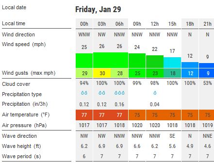
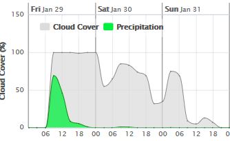
Skies will be mostly clear.  Winds will be  light and easterly in direction at 10 mph this morning; increasing to 15 mph to 25 mph this afternoon and evening. Seas will be moderate at 1 ft to 4 ft. There is a very slight chance of rain showers this morning.
The air temperatures will range from the low 70sºF to mid 80s ºF or 25°C to 27ºC. Ocean water temperatures are 78°F to 82°F or 25ºC to 27ºC.


The Tropical Weather Outlook
For the North Atlantic...Caribbean Sea and the Gulf of Mexico:
1. A strong cold front moving off the Texas coast Tue will reach from SE Louisiana to Tampico, Mexico Tue night...from Apalachicola, FL to the Bay of Campeche, Mexico Wed night and from Tampa Bay, FL to the NE Yucatan Peninsula Thu night. Strong to near- gale winds are likely W of the front primarily in the SW Gulf of Mexico Wed and Thu.
2. A stationary front from the Windward Passage to the NE coast of Honduras will dissipate today. SE winds will increase in the Gulf of Honduras Mon night and Tue night ahead of a cold front that will move into the Yucatan Channel by Fri morning.

Fig 3 - Recent changes in the Saharan Air Layer
The Tides: Moon and Sun
high tide 4:07 pm LT                                                 Sunrise – 6:18 am LT>108° East
low tide 9:12 am LT                                                  Sunset – 5:44 pm LT < 252° West
high tide 2:38 pm LT                                                 Moon Rise – 12:11 pm LT> 103° East
low tide 9:41 pm LT                                                  Moon Set – 11:22 am LT < 259° West

Fig 4 - Moon

Day Light Hours: 11 hours, 26 minutes (+40)

Saturday, January 30, 2016

Mostly Cloudy

The CoCoView Resort Weather Forecast
This weather forecast is intended for CoCoView Resort guests and applies only to the south side of Roatan
CoCoView is at 16.4°N Latitude x 86.4°W Longitude
in the
   NW Caribbean Sea

             CoCoView Resort, www.cocoviewresort.com , 800-510-8164


Saturday, January 30, 2016
Skies will be mostly cloudy.  Winds will be  light and variable in direction at 10 mph or less. Seas will be calm at 1 ft to 3 ft.
The air temperatures will range from the low 70sºF to mid 80s ºF or 25°C to 27ºC. Ocean water temperatures are 78°F to 82°F or 25ºC to 27ºC.


The Tropical Weather Outlook
For the North Atlantic...Caribbean Sea and the Gulf of Mexico:
1. A strong cold front moving off the Texas coast on Tue will reach from SE Louisiana to Tampico, Mexico early Wed morning.
2. A cold front extends from eastern Cuba to 18N79W where it becomes stationary. The front will gradually dissipate through Sun.

Fig 3 - Recent changes in the Saharan Air Layer
The Tides: Moon and Sun 
high tide 2:51 pm LT                                                 Sunrise – 6:18 am LT>108° East
low tide 7:50 am LT                                                  Sunset – 5:43 pm LT < 252° West
high tide 1:32 pm LT                                                 Moon Rise – 11:24 pm LT> 99° East
low tide 8:36 pm LT                                                  Moon Set – 10:42 am LT < 263° West

Fig 4 - Moon

Friday, January 29, 2016

Mostly Cloudy with Northerly Winds

The CoCoView Resort Weather Forecast
This weather forecast is intended for CoCoView Resort guests and applies only to the south side of Roatan
CoCoView is at 16.4°N Latitude x 86.4°W Longitude
in the
   NW Caribbean Sea

             CoCoView Resort, www.cocoviewresort.com , 800-510-8164


Friday, January 29, 2016
Skies will be mostly cloudy.  Winds will be  northerly in direction at 30 mph to 15 mph or less. Seas will be moderate to rough at 1 ft to 4 ft.  There is a chance of rain  Friday morning.
The air temperatures will range from the low 70sºF to mid 80s ºF or 25°C to 27ºC. Ocean water temperatures are 78°F to 82°F or 25ºC to 27ºC.


The Tropical Weather Outlook
For the North Atlantic...Caribbean Sea and the Gulf of Mexico:1. The Gulf of Mexico - Strong NW winds behind a cold front just SE of the area will diminish through this morning. The next cold front is expected to move off the Texas coast early Tue and reach from Mobile Bay, AL to Tampico Mexico by Tue night.
2. A cold front from the Isle of Youth, Cuba to the Gulf of Honduras will stretch from E Cuba to along the coast of Nicaragua tonight...then become stationary and dissipate through Sun.

Fig 3 - Recent changes in the Saharan Air Layer
The Tides: Moon and Sun 
high tide 1:24 pm LT                                                 Sunrise – 6:18 am LT>108° East
low tide 5:30 am LT                                                  Sunset – 5:43 pm LT < 252° West
high tide 11:33 am LT                                               Moon Rise – 10:37 pm LT> 95° East
low tide 6:17 pm LT                                                  Moon Set – 10:04 am LT < 267° West
Fig 4 - Moon

Thursday, January 28, 2016

Partly Sunny with Moderate Winds

The CoCoView Resort Weather Forecast
This weather forecast is intended for CoCoView Resort guests and applies only to the south side of Roatan
CoCoView is at 16.4°N Latitude x 86.4°W Longitude
in the
   NW Caribbean Sea

             CoCoView Resort, www.cocoviewresort.com , 800-510-8164


Thursday, January 28, 2016
Skies will be partly sunny.  Winds will be  westerly in direction at 10 mph to 25 mph or higher. Seas will be calm to moderate at 1 ft to 3 ft.  There is a chance of rain  late Thursday and Friday with the passage of a new cold front.
The air temperatures will range from the low 70sºF to mid 80s ºF or 25°C to 27ºC. Ocean water temperatures are 78°F to 82°F or 25ºC to 27ºC.


The Tropical Weather Outlook
For the North Atlantic...Caribbean Sea and the Gulf of Mexico:
1. A cold front extends from Tampa Bay to the Bay of Campeche, Mexico. moderate to fresh southerly return flow expected across the entire Gulf of Mexico on Sat and Sun. The next cold front will move off the Texas coast on Mon night.
2. Fresh to strong E trades across the Caribbean E of 78W will diminish on Thu. A cold front will move into the NW Caribbean Thu afternoon...reaching from central Cuba to E Honduras on Fri morning...and from E Cuba to near 17N82W Fri night...then becoming stationary and dissipating through Sun.

Fig 3 - Recent changes in the Saharan Air Layer
The Tides: Moon and Sun
low tide 5:30 am LT                                               Sunrise – 6:18 am LT>109° East
high tide 11:33 am LT                                            Sunset – 5:42 pm LT < 251° West
low tide 6:17 pm LT                                               Moon Rise – 9:29 pm LT> 91° East
high tide 1:24 pm LT                                              Moon Set – 9:49 am LT < 271° West
Fig 4 - Moon

Day Light Hours:11 hours, 24 minutes (+38)

Tuesday, January 26, 2016

Mostly Sunny with Moderate Winds and Seas

The CoCoView Resort Weather Forecast
This weather forecast is intended for CoCoView Resort guests and applies only to the south side of Roatan
CoCoView is at 16.4°N Latitude x 86.4°W Longitude
in the
   NW Caribbean Sea

             CoCoView Resort, www.cocoviewresort.com , 800-510-8164


Tuesday, January 26, 2016
Skies will be mostly sunny.  Winds will be mostly easterly in direction at 10 mph to 25 mph. Seas will be moderate to rough  at 2 ft to 4 ft or higher.  Divers should exercise caution exiting and entering the boats, especially on the afternoon dives.There is a chance of rain  Thursday thru Saturday.
The air temperatures will range from the low 70sºF to mid 80s ºF or 25°C to 27ºC. Ocean water temperatures are 78°F to 82°F or 25ºC to 27ºC.


The Tropical Weather Outlook
For the North Atlantic...Caribbean Sea and the Gulf of Mexico:1. A cold front over the far NW Gulf of Mexico at sunrise this morning will reach from the Mississippi Delta to the Bay of Campeche tonight...and from the Florida Big Bend to the Yucatan Peninsula on Wed evening.
2. A tightening pressure gradient will support fresh to strong NE to E winds across the central Caribbean...including the Windward Passage. A cold front will move into the NW Caribbean on Wed night...reach from E Cuba to Nicaragua late Thu night...and from Haiti to Costa Rica late Fri night where it will stall and gradually dissipate through Sat night.

Fig 3 - Recent changes in the Saharan Air Layer
The Tides: Moon and Sun
low tide 4:00 am LT                                               Sunrise – 6:18 am LT>109° East
high tide 10:20 am LT                                            Sunset – 5:41 pm LT < 251° West
low tide 4:38 pm LT                                               Moon Rise – 8:11 pm LT> 83° East
high tide 10:53 pm LT                                           Moon Set – 8:05 am LT < 278° West

Fig 4 - Moon

Monday, January 25, 2016

Mostly Cloudy with a Chance of Rain

The CoCoView Resort Weather Forecast
This weather forecast is intended for CoCoView Resort guests and applies only to the south side of Roatan
CoCoView is at 16.4°N Latitude x 86.4°W Longitude
in the
   NW Caribbean Sea

             CoCoView Resort, www.cocoviewresort.com , 800-510-8164


Monday, January 25, 2016
Skies will be mostly cloudy.  Winds will be mostly easterly in direction at 10 mph to 25 mph. Seas will be moderate to rough  at 2 ft to 4 ft or higher.  Divers should exercise caution exiting and entering the boats, especially on the afternoon dives.There is a chance of rain today with the continued passage of a cold front.
The air temperatures will range from the low 70sºF to mid 80s ºF or 25°C to 27ºC. Ocean water temperatures are 78°F to 82°F or 25ºC to 27ºC.


The Tropical Weather OutlookFor the North Atlantic...Caribbean Sea and the Gulf of Mexico:
1. A cold front will move into the NW Gulf of Mexico BY Tue afternoon quickly reaching from the Florida Panhandle to Veracruz, Mexico Wed morning...and from SW Florida to the N central Yucatan T
2. A stationary front from SW Haiti to western Panama will gradually dissipate through Tue. Strong to near gale force northerly winds along the coast of Nicaragua will diminish tonight. Another cold front will move into the NW Caribbean Wed night into early Thu and reach from eastern Cuba to eastern Honduras by Fri morning with fresh to strong northerly winds behind the front.
Fig 3 - Recent changes in the Saharan Air Layer
The Tides: Moon and Sun
low tide 3:24 am LT                                               Sunrise – 6:18 am LT>110° East
high tide 9:48 am LT                                              Sunset – 5:41 pm LT < 251° West
low tide 3:59 pm LT                                               Moon Rise – 7:20 pm LT> 80° East
high tide 10:02 pm LT                                           Moon Set – 7:22 am LT < 282° West

Fig 4 - Moon

Day Light Hours: 11 hours, 22 minutes (+36)

Friday, January 22, 2016

Cloudy with Rain

The CoCoView Resort Weather Forecast
This weather forecast is intended for CoCoView Resort guests and applies only to the south side of Roatan
CoCoView is at 16.4°N Latitude x 86.4°W Longitude
in the
   NW Caribbean Sea

             CoCoView Resort, www.cocoviewresort.com , 800-510-8164


Friday, January 22, 2016
Skies will be partly cloudy.  Winds will be mostly westerly in direction at 5 mph to 25 mph. Seas will be calm to rough at 1 ft to 4 ft. or higher  There is a chance of rain late today and tomorrow with the passage of a cold front.
The air temperatures will range from the low 70sºF to mid 80s ºF or 25°C to 27ºC. Ocean water temperatures are 78°F to 82°F or 25ºC to 27ºC.


The Tropical Weather Outlook1. A cold front extending from the Florida Panhandle through the central Gulf of Mexico to Mexico near 18N93W will race through the basin today shifting E of the area tonight. Strong to gale force winds will follow the front...diminishing from W to E through Sat. Another cold front will move off the Texas coast on Mon. That front will reach from the Florida Big Bend to the Bay of Campeche, Mexico around sunrise on Wed with near gale conditions developing across the W central Gulf of Mexico.
2. Atlantic high pressure will support strong trades across the S central and SE Caribbean through Sat. A strong cold front will move into the NW Caribbean this afternoon...reaching from central Cuba to NE Nicaragua Sat morning...from the Windward Passage to Costa Rica by Sun morning...then will stall and weaken from the Dominican Republic to western Panama by early Mon and become diffuse through early Tue.

Fig 3 - Recent changes in the Saharan Air Layer
The Tides: Moon and Sun
low tide 1:36 am LT                                               Sunrise – 6:19 am LT>111° East
high tide 8:08 am LT                                              Sunset – 5:39 pm LT < 250° West
low tide 2:08 pm LT                                               Moon Rise – 4:38 pm LT> 72° East
high tide 7:50 pm LT                                              Moon Set – 4:54 am LT < 289° West

Fig 4 - Moon

Thursday, January 21, 2016

Partly Cloudy with Moderate Winds

The CoCoView Resort Weather Forecast
This weather forecast is intended for CoCoView Resort guests and applies only to the south side of Roatan
CoCoView is at 16.4°N Latitude x 86.4°W Longitude
in the
   NW Caribbean Sea

             CoCoView Resort, www.cocoviewresort.com , 800-510-8164


Thursday, January 21, 2016 
Skies will be partly cloudy.  Winds will be mostly westerly in direction at 5 mph to 15 mph. Seas will be calm to moderate at 1 ft to 4 ft.  There is a slight chance of rain late this morning.
The air temperatures will range from the high 70sºF to mid 80s ºF or 25°C to 27ºC. Ocean water temperatures are 78°F to 82°F or 25ºC to 27ºC.


The Tropical Weather Outlook
For the North Atlantic...Caribbean Sea and the Gulf of Mexico: 
1. High pressure offshore of NE Florida will shift E today ahead of a strong cold front that will move into the NW Gulf of Mexico late Fri...and reach from Panama City, FL to S of Veracruz, Mexico by early Sat. Winds at or near gale force are likely behind the front across the N Gulf of Mexico...with frequent gusts to gale force and seas building 12 to 18 ft. northerly gales are expected across the Veracruz area behind the front early Fri through early afternoon. The front will shift SE of the area Fri night.
2. High pressure anchored in the SW N Atlantic N of the Bahamas will move E tonight while it weakens. A strong cold front will move into the NW Caribbean Fri night...stretching from central Cuba near 21N77W to NE Nicaragua Sat morning...from E Cuba near 20N74W SW to 16N77W by Sun morning...then stall and start to become diffuse from E Dominican Republic SW to E Jamaica to 13N80W late Mon. 

The Tides: Moon and Sun
low tide 12:56 am LT                                             Sunrise – 6:19 am LT>111° East
high tide 7:30 am LT                                              Sunset – 5:38 pm LT < 250° West
low tide 1:29 pm LT                                               Moon Rise – 3:43 pm LT> 71° East
high tide 7:06 pm LT                                              Moon Set – 3:59 am LT < 289° West

Fig 4 - Moon

Day Light Hours: 11 hours, 20 minutes (+32)

Saturday, January 16, 2016

Increasing Cloudiness with the Passage of a Cold Front

The CoCoView Resort Weather Forecast
This weather forecast is intended for CoCoView Resort guests and applies only to the south side of Roatan
CoCoView is at 16.4°N Latitude x 86.4°W Longitude
in the
   NW Caribbean Sea

             CoCoView Resort, www.cocoviewresort.com , 800-510-8164


Sunday, January 17, 2016 
Skies will be mostly sunny.  Winds will be variable in direction at 5 mph to25 mph. Seas will be moderate to rough at 2 ft to 4 ft or higher. Divers should exercise caution exiting and entering the boats, especially on the afternoon dives. Expect increasing cloudiness and rain with the passage of a cold front
The air temperatures will range from the high 70sºF to mid 80s ºF or 25°C to 27ºC. Ocean water temperatures are 78°F to 82°F or 25ºC to 27ºC.


The Tropical Weather Outlook
For the North Atlantic...Caribbean Sea and the Gulf of Mexico: 
1. A cold front from Apalachicola, Florida becomes stationary from 28.5N89W to 999 mb low pressure near 28N92W then cold front to 23N98W. A squall line lies approximately 150 nm ahead of the front N of 23N. The low move rapidly eastward while intensifying over the northern waters overnight...dragging a cold front across the basin through Sun. A new cold front will move into NW Gulf of Mexico Thu. 
2. Weak ridging will extend across much of the N Caribbean today ahead of a cold front that will move into the NW Caribbean Sun. The front will extend from central Cuba to NE Honduras Mon morning then stall from the Windward Passage to NE Honduras Tue night where it will dissipate through Wed
Fig 3 - Recent changes in the Saharan Air Layer
The Tides: Moon and Sun
high tide 4:09 am LT                                             Sunrise – 6:18 am LT>111° East
low tide 10:01 am LT                                            Sunset – 5:36 pm LT < 249° West
high tide 3:33 pm LT                                             Moon Rise – 12:16 pm LT> 79° East
low tide 10:26 pm LT                                            Moon Set – 1:04 am LT < 279° West


Fig 4 - Moon

Day Light Hours:  11 hours, 18 minutes (+29)


Again Mostly Sunny

The CoCoView Resort Weather Forecast
This weather forecast is intended for CoCoView Resort guests and applies only to the south side of Roatan
CoCoView is at 16.4°N Latitude x 86.4°W Longitude
in the
   NW Caribbean Sea

             CoCoView Resort, www.cocoviewresort.com , 800-510-8164


Saturday, January 16, 2016 
Skies will be mostly sunny.  Winds will be mostly easterly in direction at 5 mph to10 mph or less. Seas will be moderate to choppy at 1 ft to 3 ft. 
The air temperatures will range from the high 70sºF to mid 80s ºF or 25°C to 27ºC. Ocean water temperatures are 78°F to 82°F or 25ºC to 27ºC.


The Tropical Weather Outlook
For the North Atlantic...Caribbean Sea and the Gulf of Mexico: 
1. A cold front from near Naples, Florida to 22N90W will begin to drift N.  A new cold front will move across the Gulf of Mexico through Sun.
2. Weak ridging will extend across much of the N Caribbean today ahead of a cold front that will move into the NW Caribbean Sun...stretch from central Cuba to NE Honduras Mon morning...stall from Windward Passage to NE Honduras Tue night then weaken as it drifts from Windward Passage to N Honduras Wed.


Fig 3 - Recent changes in the Saharan Air Layer

The Tides: Moon and Sun
high tide 2:53 am LT                                             Sunrise – 6:18 am LT>112° East
low tide 8:38 am LT                                              Sunset – 5:35 pm LT < 248° West
high tide 2:27 pm LT                                             Moon Rise – 11:29 am LT> 83° East
low tide 9:21 pm LT                                              Moon Set – 12:06 pm LT < 279° West

Fig 4 - Moon

Day Light Hours:  11 hours, 17 minutes (+28)

Friday, January 15, 2016

Mostly Sunny

The CoCoView Resort Weather Forecast
This weather forecast is intended for CoCoView Resort guests and applies only to the south side of Roatan
CoCoView is at 16.4°N Latitude x 86.4°W Longitude
in the
   NW Caribbean Sea

             CoCoView Resort, www.cocoviewresort.com , 800-510-8164


Friday, January 15, 2016 
Skies will be mostly sunny.  Winds will be mostly easterly in direction at 5 mph to10 mph or less. Seas will be moderate to choppy at 1 ft to 3 ft.
The air temperatures will range from the high 70sºF to mid 80s ºF or 25°C to 27ºC. Ocean water temperatures are 78°F to 82°F or 25ºC to 27ºC.


The Tropical Weather Outlook
For the North Atlantic...Caribbean Sea and the Gulf of Mexico: 
1. A cold front across the Gulf of Mexico through Sun. 
2. A frontal trough will become stationary across the Yucatan Channel and far NW Caribbean early tonight then lift N into SE Gulf of Mexico Sat afternoon. Another cold front will move into the NW Caribbean Sun...stretch from E central Cuba to N Honduras Mon morning and from the Windward passage to SE Nicaragua Tue morning. Otherwise gentle to moderate trades are expected across the area E of 80W...except moderate to fresh across the S central Caribbean and increasing to strong along the NW coast of Colombia during the overnight hours.

Fig 3 - Recent changes in the Saharan Air Layer

The Tides: Moon and Sun
high tide 1:23 am LT                                             Sunrise – 6:18 am LT>112° East
low tide 7:12 am LT                                              Sunset – 5:35 pm LT < 248° West
high tide 1:17 pm LT                                             Moon Rise – 10:42 am LT> 88° East
low tide 8:10 pm LT                                              Moon Set – 11:09 pm LT < 274° West


Fig 4 - Moon

Day Light Hours: 11 hours, 17 minutes (+27)


Wednesday, January 13, 2016

Mostly Sunny with Light Easterly Winds

The CoCoView Resort Weather Forecast
This weather forecast is intended for CoCoView Resort guests and applies only to the south side of Roatan
CoCoView is at 16.4°N Latitude x 86.4°W Longitude
in the
   NW Caribbean Sea

             CoCoView Resort, www.cocoviewresort.com , 800-510-8164


Saturday,  September 19, 2015
Skies will be partly cloudy. Winds will be light and mostly easterly in direction at 5 mph to 10 mph or less today. Seas will be calm to moderate at 1 ft to 3 ft.
The air temperatures will range from the low to high 80s ºF or 26°C to 27ºC. Ocean water temperatures are 82°F to 84°F or 27ºC to 29ºC. There is a chance of scattered rain showers and isolated thunderstorms today.


The Tropical Weather Outlook
For the North Atlantic...Caribbean Sea and the Gulf of Mexico: 
1. New low pressure will potentially move into the NW Gulf of Mexico Sat dragging a cold front across the basin through Sun. 
2..A weak cold front will dissipate across the tropical waters E of the Leewards overnight. A stationary front from central Cuba to Tulum, Mexico will gradually dissipate through Thu. A second cold front will move into the NW Caribbean Fri night and dissipate from E Cuba to Belize Sat. A third cold front will move into the NW Caribbean Sun.


Fig 3 - Recent changes in the Saharan Air Layer

The Tides: Moon and Sun
low tide 4:50 am LT                                           Sunrise – 6:18 am LT>112° East
high tide 11:13 am LT                                        Sunset – 5:34 pm LT < 248° West
low tide 5:50 pm LT                                           Moon Rise – 9:08 am LT> 97° East
high tide 11:50 pm LT                                        Moon Set – 9:14 pm LT < 265° West


Fig 4 - Moon

Day Light Hours:11 hours, 16 minutes (+25)