Wednesday, September 30, 2015

Again Partly Sunny with Moderate Winds and Seas

The CoCoView Resort Weather Forecast
This weather forecast is intended for CoCoView Resort guests and applies only to the south side of Roatan
CoCoView is at 16.4°N Latitude x 86.4°W Longitude
in the
   NW Caribbean Sea

             CoCoView Resort, www.cocoviewresort.com , 800-510-8164


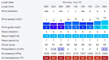
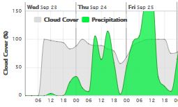
Wednesday,  September 30, 2015Skies will be partly cloudy. Winds will be light and mostly easterly in direction at 5 mph to 10 mph or less today. Seas will be  moderate to calm at 1 ft to 3 ft.
The air temperatures will range from the low to high 80s ºF or 26°C to 27ºC. Ocean water temperatures are 84°F to 87°F or 29ºC to 31ºC.


The Tropical Weather Outlook
For the North Atlantic...Caribbean Sea and the Gulf of Mexico:
1. Synopsis...Gentle to moderate trade winds will prevail across most of the Caribbean. Gentle to moderate trade winds will prevail the remainder of the forecast.
2. There are two areas of disturbed weather in the Atlantic-Caribbean-Gulf of Mexico basin. None of them, currently poses a threat to the Bay Islands or north coast of Honduras. TS Joaquin may become a hurricane today.
By: Bob Henson and Jeff Masters , 9:08 PM GMT on September 29, 2015

Tropical Storm Joaquin is gaining strength as it moves slowly west-southwest toward the eastern Bahamas. Joaquin’s top sustained winds were upgraded from 50 to 65 mph in the 5:00 pm EDT Tuesday advisory from the National Hurricane Center (NHC). An Air Force hurricane-hunter aircraft found a central pressure of 990 millibars, a substantial drop from this morning. From aboard the aircraft, NOAA’s Stepped Frequency Microwave Radiometer detected surface winds on the order of 60-65 mph (see Figure 2) at around 2:00 pm EDT. Joaquin has struggled in the face of wind shear of 20-25 knots due to strong upper-level winds from the north-northwest; earlier Tuesday, the the low-level center of circulation exposed to view with all of the storm's heavy thunderstorms limited to the southeast side of the center. However, the thunderstorms maintained their vigor with the help of very warm waters and excellent outflow toward the south side of Joaquin, and on Tuesday afternoon an intense burst of thunderstorms developed atop the low-level center. With this consolidation, Joaquin has a much better chance to intensify further in the next 24 hours. Wind shear will be dropping below 20 knots by Wednesday and may dip below 15 knots for several days, lending more support to intensification. NHC now projects that Joaquin will be a hurricane by midday Wednesday.


Figure 1. Infrared satellite image of Tropical Storm Joaquin, collected at 1945Z (3:45 pm EDT) on Tuesday, September 29, 2015. Image credit: NOAA/NESDIS.


Figure 2. MODIS image of Tropical Storm Joaquin near the Bahamas as seen from NASA's Aqua satellite on Tuesday, September 29, 2015, at approximately 10:30 am EDT. At the time, Joaquin had top winds of 45 mph. Image credit: NASA.


Figure 3. Surface winds (blue line) and precipitation (red line) as measured by the Stepped Frequency Microwave Radiometer (SFMR) instrument on an Air Force hurricane hunter aircraft on Tuesday, September 29, 2015, between 1:35 - 3:34 pm EDT. Surface winds peaked at about 57 knots (66 mph) at 2:13 pm, during a period when heavy rain was observed. Surface winds of 51 knots (59 mph) were observed during a period of low precipitation. Image credit: Levi Cowan, tropicaltidbits.com.


Over the next couple of days, models agree that Joaquin will continue moving slowly toward the west-southwest, which will pose an increasing threat to the eastern Bahamas. The NHC may issue watches or warnings for the Bahamas later Tuesday night. Most of the 12Z Tuesday computer models stop Joaquin in its tracks just short of the Bahamas, but the usually reliable ECMWF model suggests a greater motion toward the southwest, indicating a potential threat to some of the eastern islands. During its slow westward trek, Joaquin will be passing over ocean temperatures near 30°C (86°F)--the warmest seen there since record keeping began in 1880. Oceanic heat content--the amount of energy stored in the upper 50 meters (160 feet) of the ocean--is another index of potential strengthening. Joaquin’s track should take it across the boundary into oceanic heat content values greater than 50 kilojoules per square centimeter by Wednesday. For tropical storms and Category 1 hurricanes, values of heat content greater than 50 kJ/cm2 have been associated with more rapid intensification rates, assuming that wind shear is less than 15 knots, mid-level relative humidity is greater than 50 percent, and SSTs are at least 28.5°C. Joaquin should meet most or all of these criteria over the next couple of days, which raises the possibility of robust intensification.


Figure 4. On Tuesday, September 29, 2015, Tropical Storm Joaquin was located in an area of ocean with record Sea Surface Temperatures (SSTs) of 30°C (86°F). Image credit: NOAA/NCEI.


Figure 5. Oceanic heat content across the Northwest Atlantic as of September 28, 2015. Values of greater than 50 kJ/cm2 are related to more rapid intensification of tropical cyclones up to Category 1 strength, assuming that other conditions are supportive (warm SSTs, moist mid-level air, and light wind shear). Image credit: NOAA/AOML.


The long-range outlook for Joaquin
The 12Z Tuesday model runs did not clarify the unusually muddy waters surrounding the future track of Joaquin. By Friday, the eastern U.S. trough should begin to influence Joaquin and give it a northward component of motion, but the exact configuration of that trough--which will be critical to Joaquin’s track beyond Day 3--is still unclear. The models continue to show huge differences from run-to-run and with each other on just how this trough will develop and interact with Joaquin. The general tendency is for this trough to take on a negative tilt (a NW-to-SE configuration), with upper-level ridging becoming stronger off New England. All else being equal, this would tend to result in a more northwesterly path for Joaquin. Complicating the forecast is the presence of several areas of disturbed weather, including the remnants of Invest 99L (now over northern Florida); Invest 90L (incorporating the remnants of Tropical Storm Ida); and a frontal zone across the Northeast that will produce torrential rain (see below). All of these systems will pump large amounts of heat into the atmosphere through condensation, and this in turn will influence how the situation evolves.


Figure 6. Two model runs, just 12 hours apart, from one of our top models for predicting hurricane tracks--the European model--showed radically different solutions over 900 miles apart for where Joaquin might be in 5 - 5.5 days. The latest model run (8 am EDT Sept 29) reverted back to a solution close to the one shown above on the left. Image credit: wundermap with the "Model Data" layer turned on.


Figure 7. Ensemble members from the GFS model run at 12Z Tuesday, September 29, 2015, show a huge spread in where Joaquin might end up. The ensemble is produced by running the model multiple times, each time varying the starting-point conditions slightly to mimic observational uncertainty.

The model guidance from 12Z Tuesday shows two main possibilities by Days 5 and 6. The HWRF, GFDL, and UKMET models all depict a hurricane heading toward the mid-Atlantic by this weekend, tucking into the north side of the negatively tilted trough. In contrast, the ECMWF and GFS models show Joaquin heading out to the open Atlantic well before approaching the U.S. East Coast, as the trough pushes Joaquin eastward rather than pulling it into its northeast side. Various members of the ECMWF and GFS model ensembles have a wide range of solutions (see Figure 7 at right). Given the complexity of the factors involved, it is far too soon to put too much stock in any particular model solution. This is a good time to keep in mind that the width of the National Hurricane Center’s “cone of uncertainty” is based on average historical forecast errors from the last five years. In the case of Joaquin, the long-range uncertainty indicated by the models right now appears even larger than the cone’s historical database would suggest, which calls for even more caution than usual in focusing on any possible outcome. Data from the first dropsonde mission into Joaquin this afternoon by the NOAA Gulfstream-IV jet should make Tuesday night's 00Z suite of computer model forecasts more reliable than the Tuesday morning runs.

Regardless: heavy rain event coming to northern Appalachians and New England
Independent of Joaquin, an unusually intense heavy-rain event will be striking the northern Appalachians and New England over the next 2-3 days. Deep tropical moisture streaming northeastward from the Gulf of Mexico will lead to near-record high amounts of water vapor for the location and time of year. This moisture will intercept a preexisting frontal boundary, as rain-producing impulses move along the east side of the sprawling upper-level trough over the eastern U.S. The NOAA Storm Prediction Center is calling for widespread 3-5” rainfall from 00Z Wednesday to 00Z Friday from eastern New York across most of New England to southeastern Maine. Models are in fairly strong agreement that this heavy rain will develop, but there is some uncertainty on where the rains will be heaviest--in particular, the placement of the southwest-northeast stripe where training echoes could lead to particularly large amounts. Dry conditions have prevailed over the mid-Atlantic and New England over the last few weeks, moderate drought near the coast, so most locations could handle several inches of rain before general flooding became an issue. However, if intense rains fall in a short period over mountainous areas, some smaller creeks and streams could respond quickly and produce a localized flash flood threat. Urban areas from New York to Portland may also experience street flooding if the heaviest rains materialize there, as the drainage systems struggle to keep up. If Joaquin happens to move into New England early next week, there would be a much greater risk of widespread flooding.

Which track model should you trust?
According to the 2014 National Hurricane Center Forecast Verification Report, issued in March 2015, in 2014 we had two track models that at times out-performed the official NHC forecast, a feat that is tough to do. NOAA's HWRF model did slightly better than the NHC official forecast for 2-day and 3-day forecasts, while the UK Met Office's forecast did slightly better than NHC's 4-day and 5-day forecasts. Once again, the European Center (ECMWF) and GFS models excellent performers, but the GFDL model, a excellent performer in recent years, had substantially poorer forecasts than the other four models. The Canadian CMC model and simple BAMM model had accuracies comparable to the GFDL model. The European Center model and GFS models were virtually tied as the best performing models when averaged over the three-year period 2012 - 2014.

Wunderground has a web page with computer model forecasts for Joaquin for many of the best-performing track models used to predict hurricane tracks. The European Center does not permit public display of tropical storm positions from their hurricane tracking module of their model, so we are unable to put ECMWF forecasts on this page (you can use our wundermap with the "Model Data" layer to look at ECMWF forecasts, though.) Here are some of the better models NHC regularly looks at:

ECMWF: The European Center's global forecast model
GFS: NOAA's global forecast model
UKMET: The United Kingdom Met Office's global forecast model (not evaluated by NHC in 2013)
GFDL: The Geophysical Fluid Dynamics Laboratory's hurricane model, initialized using GFS data
HWRF: The intended successor for the the GFDL hurricane model, also initialized using GFS data
NAVGEM: The Navy's global forecast model (which replaced the defunct NOGAPS model in 2013)
CMC: The Canadian GEM model
BAMM: The very old Beta and Advection Model (Medium layer), which is still useful at longer ranges

If one averages together the track forecasts from the first five of these models, the NHC official forecast will rarely depart much from it. These are the five models used to formulate the TVCA consensus model seen in Figure 8; the TVCA model was very close to the official NHC forecast in 2014.


Figure 8. Skill of computer model forecasts of Atlantic named storms in 2014, compared to a "no skill" model called "CLIPER5" that uses just climatology and persistence to make a hurricane track forecast (persistence means that a storm will tend to keep going in the direction it's current going.) OFCL=Official NHC forecast; GFS=Global Forecast System model; GFDL=Geophysical Fluid Dynamic Laboratory model; HWRF=Hurricane Weather Research Forecasting model; ECMWF=European Center for Medium Range Weather Forecasting model; UKMET=United Kingdom Met Office model; TVCA=one of the consensus models that blends together up to five of the above models; CMC=Canadian Meteorological Center (GEM) model; BAMM=Beta Advection Model (Medium depth). Data taken from the National Hurricane Center 2014 verification report.


3. The SAL has decreased in area and density.

Fig 4 - Recent changes in the Saharan Air Layer
The Tides: Moon and Sun
low tide 4:09 am LT                    Sunrise – 5:37 am LT>93° East
high tide 10:48 am LT                 Sunset – 5:38 pm LT < 267° West
low tide 4:39 pm LT                    Moon Rise – 8:07 pm LT> 76° East
high tide 10:18 pm LT                 Moon Set – 8:05 am LT < 283° West

Fig 5 - Moon

Day Light Hours:  12 hours,  (-52 sec)

Tuesday, September 29, 2015

Partly Sunny with Moderate Winds

The CoCoView Resort Weather Forecast
This weather forecast is intended for CoCoView Resort guests and applies only to the south side of Roatan
CoCoView is at 16.4°N Latitude x 86.4°W Longitude
in the
   NW Caribbean Sea

             CoCoView Resort, www.cocoviewresort.com , 800-510-8164


Tuesday,  September 29, 2015Skies will be partly cloudy. Winds will be light and mostly easterly in direction at 5 mph to 10 mph or less this morning; increasing to 15 mph to 20 mph this afternoon and evening. today. Seas will be  moderate to calm at 1 ft to 4 ft.
The air temperatures will range from the low to high 80s ºF or 26°C to 27ºC. Ocean water temperatures are 82°F to 84°F or 27ºC to 29ºC.


The Tropical Weather Outlook
For the North Atlantic...Caribbean Sea and the Gulf of Mexico:
1. Synopsis...Gentle to moderate trade winds will prevail across most of the Caribbean. Gentle to moderate trade winds will prevail the remainder of the forecast.
2. There are three areas of disturbed weather in the Atlantic-Caribbean-Gulf of Mexico basin. None of them, currently poses a threat to the Bay Islands or north coast of Honduras.


3. The SAL has decreased in area and density.

Fig 4 - Recent changes in the Saharan Air Layer
The Tides: Moon and Sun
low tide 3:13 am LT                    Sunrise – 5:37 am LT>92° East
high tide 9:44 am LT                   Sunset – 5:39 pm LT < 268° West
low tide 3:40 pm LT                    Moon Rise – 7:15 pm LT> 80° East
high tide 9:20 pm LT                   Moon Set – 7:03 am LT < 278° West
Fig 5 - Moon

Day Light Hours:  12 hours, 1 minutes, (-52 sec)

Monday, September 28, 2015

Mostly Cloudy with Light, Variable Winds

The CoCoView Resort Weather Forecast
This weather forecast is intended for CoCoView Resort guests and applies only to the south side of Roatan
CoCoView is at 16.4°N Latitude x 86.4°W Longitude
in the
   NW Caribbean Sea

             CoCoView Resort, www.cocoviewresort.com , 800-510-8164


Monday,  September 28, 2015Skies will be mostly cloudy. Winds will be light and mostly easterly in direction at 10 mph to 15 mph or less today. Seas will be  moderate to calm at 1 ft to 3 ft.
The air temperatures will range from the low to high 80s ºF or 26°C to 27ºC. Ocean water temperatures are 82°F to 84°F or 27ºC to 29ºC. There is a chance of scattered rain showers and isolated thunderstorms through later today.


The Tropical Weather Outlook
 For the North Atlantic...Caribbean Sea and the Gulf of Mexico:
1.Synopsis...Gentle to moderate trade winds will prevail across most of the Caribbean. Broad low pressure covers most of the Gulf of Mexico with a small 1007 mb low center just off the N coast of the Yucatan. The low center will move N across the central Gulf of Mexico through Mon and aid in producing fresh SE winds with squalls continuing over much of the NW Caribbean tonight before diminishing through late Mon.
2. There are two areas of disturbed weather in the Atlantic-Caribbean-Gulf of Mexico basin. None of them, currently poses a threat to the Bay Islands or north coast of Honduras.
3. Today's SAL data is currently not available.

4. Eathquake Activity
Date & time: Mon, 28 Sep 13:37:04 UTC
Magnitude: 4.9
Depth: 10.0 km
Epicenter latitude / longitude: 16.61°N / 86.34°W [Map]
Nearest volcano: Utila (82 km)
Primary data source: GFZ


The Tides: Moon and Sun
 low tide 2:22 am LT                    Sunrise – 5:37 am LT>92° East
high tide 8:46 am LT                   Sunset – 5:40 pm LT < 268° West
low tide 2:47 pm LT                    Moon Rise – 6:24 pm LT> 84° East
high tide 8:32 pm LT                   Moon Set – 6:01 am LT < 273° West

Fig 5 - Moon

Day Light Hours:  12 hours, 2 minutes, (-52 sec)

Sunday, September 27, 2015

Tonight There will be a Total Lunar Eclipse

The CoCoView Resort Weather Forecast
This weather forecast is intended for CoCoView Resort guests and applies only to the south side of Roatan
CoCoView is at 16.4°N Latitude x 86.4°W Longitude
in the
   NW Caribbean Sea

             CoCoView Resort, www.cocoviewresort.com , 800-510-8164


Sunday,  September 27, 2015
Skies will be mostly cloudy. Winds will be light and mostly easterly in direction at 10 mph to 15 mph or less today. Seas will be  moderate to calm at 1 ft to 3 ft.
The air temperatures will range from the low to high 80s ºF or 26°C to 27ºC. Ocean water temperatures are 82°F to 84°F or 27ºC to 29ºC. There is a chance of scattered rain showers and isolated thunderstorms today through today.

Today's Total Lunar Eclipse.
Begins: Sun, 27 Sept 2015, 18:11.
Maximum: Sun, 27 Sept 2015, 20:47.
Ends: Sun, 27 Sept 2015, 23:22.
Duration: 5 hours, 11 minutes


The Tropical Weather Outlook
For the North Atlantic...Caribbean Sea and the Gulf of Mexico:
1. Synopsis...Gentle to moderate trade winds prevail across most of the Caribbean. Broad low pres has developed across the Yucatan...and will drift N across the central Gulf of Mexico through Mon. This will produce an increase in E to SE winds with squalls over much of the W Caribbean tonight and Sun before diminishing early next week.
2. There are three areas of disturbed weather in the Atlantic-Caribbean-Gulf of Mexico basin. None of them, currently poses a threat to the Bay Islands or north coast of Honduras.
3. Today's SAL data is currently not available.

The Tides: Moon and Sun
low tide 1:35 am LT                    Sunrise – 5:37 am LT>91° East
high tide 7:52 am LT                   Sunset – 5:40 pm LT < 268° West
low tide 1:58 pm LT                    Moon Rise – 5:33 pm LT> 89° East
high tide 7:50 pm LT                   Moon Set – 4:59 am LT < 268° West
Fig 4 - Moon

Day Light Hours:  12 hours, 2 minutes, (-52 sec)

Saturday, September 26, 2015

Mostly Cloudy with Light tooderate Winds and Seas

The CoCoView Resort Weather Forecast
This weather forecast is intended for CoCoView Resort guests and applies only to the south side of Roatan
CoCoView is at 16.4°N Latitude x 86.4°W Longitude
in the
   NW Caribbean Sea

             CoCoView Resort, www.cocoviewresort.com , 800-510-8164


Saturday,  September 26, 2015Skies will be mostly cloudy. Winds will be light and mostly easterly in direction at 10 mph to 15 mph or less today. Seas will be  moderate to calm at 1 ft to 3 ft.
The air temperatures will range from the low to high 80s ºF or 26°C to 27ºC. Ocean water temperatures are 82°F to 84°F or 27ºC to 29ºC. There is a chance of scattered rain showers and isolated thunderstorms today through Sunday.


The Tropical Weather Outlook
For the North Atlantic...Caribbean Sea and the Gulf of Mexico:
1. Synopsis...Weak ridging across the SW N Atlantic will continue to support gentle to moderate trade winds across most of the Caribbean through Sat night. Scattered showers and thunderstorms will persist along and E of a trough across the Yucatan along 87W/88W tonight and Sat as the trough drifts westward across the Yucatan Peninsula. Broad low pressure is expected to develop across the Yucatan Sun and drift N into the central Gulf of Mexico Sun through Mon...and produce increasing E to SE winds over much of the W Caribbean Sat through Sun night...then diminish early next week.
2. There are three areas of disturbed weather in the Atlantic-Caribbean-Gulf of Mexico basin. TD Ida currently poses no threat to the Bay Islands or north coast of Honduras. It is expected to become a remnant low in the next few days.
3. Total Lunar Eclipse Data

Begins:  Sun, 27 Sept 2015, 18:11
Maximum:  Sun, 27 Sept 2015, 20:47
Ends:  Sun, 27 Sept 2015, 23:22

Duration:  5 hours, 11 minutes


3. The SAL has increased slightly in area and density.

Fig 4 - Recent changes in the Saharan Air Layer
The Tides: Moon and Sun
low tide 12:51 am LT                  Sunrise – 5:37 am LT>91° East
high tide 7:01 am LT                   Sunset – 5:41 pm LT < 269° West
low tide 1:12 pm LT                    Moon Rise – 4:43 pm LT> 94° East
high tide 7:11 pm LT                   Moon Set – 3:58 am LT < 263° West
Fig 5 - Moon

Day Light Hours:  12 hours, 3 minutes, (-52 sec)

Friday, September 25, 2015

Mostly Cloudy Skies

The CoCoView Resort Weather Forecast
This weather forecast is intended for CoCoView Resort guests and applies only to the south side of Roatan
CoCoView is at 16.4°N Latitude x 86.4°W Longitude
in the
   NW Caribbean Sea

             CoCoView Resort, www.cocoviewresort.com , 800-510-8164


Friday,  September 25, 2015Skies will be partly cloudy. Winds will be light and mostly easterly in direction at 10 mph to 15 mph this morning; increasing to 20 mph to 25 mph this afternoon and evening. Seas will be  moderate at 2 ft to 4 ft.
The air temperatures will range from the low to high 80s ºF or 26°C to 27ºC. Ocean water temperatures are 82°F to 84°F or 27ºC to 29ºC. There is a chance of scattered rain showers and isolated thunderstorms today through Sunday.


The Tropical Weather OutlookFor the North Atlantic...Caribbean Sea and the Gulf of Mexico:
1. Synopsis...Weak ridging N of the area will continue to support gentle to moderate trade winds across most of the Caribbean through Sat. A trough of low pres over the W Caribbean is generating disorganized showers and thunderstorms. This trough is forecast to move westward reaching the southern Gulf of Mexico by late this weekend. This will allow increased E to SE winds over much of the W Caribbean Fri night through Sun night...diminishing early next week.
2. There are two areas of disturbed weather in the Atlantic-Caribbean-Gulf of Mexico basin. TS Ida currently poses no threat to the Bay Islands or north coast of Honduras. It is expected to become a remnant low in the next few days.

3. The SAL has changed very slightly in area and density.

Fig 4 - Recent changes in the Saharan Air Layer
The Tides: Moon and Sun
low tide 12:10 am LT                  Sunrise – 5:37 am LT>91° East
high tide 6:12 am LT                   Sunset – 5:42 pm LT < 269° West
low tide 12:27 pm LT                  Moon Rise – 3:52 pm LT> 99° East
high tide 6:36 pm LT                   Moon Set – 2:57 am LT < 259° West
Fig 5 - Moon

Thursday, September 24, 2015

Again Partly Sunny with Moderate Winds and Seas

The CoCoView Resort Weather Forecast
This weather forecast is intended for CoCoView Resort guests and applies only to the south side of Roatan
CoCoView is at 16.4°N Latitude x 86.4°W Longitude
in the
   NW Caribbean Sea

             CoCoView Resort, www.cocoviewresort.com , 800-510-8164


Thursday,  September 24, 2015Skies will be partly cloudy. Winds will be light and mostly easterly in direction at 10 mph to 15 mph. Seas will be  moderate at 2 ft to 4 ft.
The air temperatures will range from the low to high 80s ºF or 26°C to 27ºC. Ocean water temperatures are 82°F to 84°F or 27ºC to 29ºC. There is a chance of scattered rain showers and isolated thunderstorms, especially during the early morning, late night hours.


The Tropical Weather Outlook 
For the North Atlantic...Caribbean Sea and the Gulf of Mexico:
1. Synopsis...weak ridging N of the area will continue to support gentle to moderate trade winds across most of the Caribbean through Fri. A trough will develop over the NW Caribbean late today and deepen to a low pressure off Belize through Sat. This will allow increased E to SE winds over much of the Western Caribbean Fri night through Sun...diminishing early next week.
2. There are two areas of disturbed weather in the Atlantic-Caribbean-Gulf of Mexico basin. TS Ida currently poses no threat to the Bay Islands or north coast of Honduras.

3. The SAL has increased very slightly in area and density.

Fig 4 - Recent changes in the Saharan Air Layer
The Tides: Moon and Sun
 high tide 5:23 am LT                  Sunrise – 5:36 am LT>90° East
low tide 11:42 am LT                 Sunset – 5:43 pm LT < 270° West
high tide 6:03 pm LT                  Moon Rise – 3:00 pm LT> 103° East
low tide 12:10 am LT                 Moon Set – 1:57 am LT < 255° West

Fig 5 - Moon

Day Light Hours:  12 hours, 5 minutes, (-52 sec)

Wednesday, September 23, 2015

Partly Sunny with Moderate Winds

The CoCoView Resort Weather Forecast
This weather forecast is intended for CoCoView Resort guests and applies only to the south side of Roatan
CoCoView is at 16.4°N Latitude x 86.4°W Longitude
in the
   NW Caribbean Sea

             CoCoView Resort, www.cocoviewresort.com , 800-510-8164


Wednesday,  September 23, 2015Skies will be partly cloudy. Winds will be light and mostly easterly in direction at 10 mph to 15 mph. Seas will be  moderate at 2 ft to 4 ft.
The air temperatures will range from the low to high 80s ºF or 26°C to 27ºC. Ocean water temperatures are 82°F to 84°F or 27ºC to 29ºC. There is a chance of scattered rain showers and isolated thunderstorms, especially during the early morning, late night hours.


The Tropical Weather OutlookFor the North Atlantic...Caribbean Sea and the Gulf of Mexico:
1. Synopsis...Weak ridging N of the area will continue to support gentle to moderate trade winds across most of the Caribbean through Fri. A trough will develop over the NW Caribbean by Fri...allowing increased E to SE winds over much of the W Caribbean into Sat.
2. There is one area of disturbed weather in the Atlantic-Caribbean-Gulf of Mexico basin. TS Ida currently poses no threat to the Bay Islands or north coast of Honduras.


3. The SAL has decreased slightly in area and density.

Fig 4 - Recent changes in the Saharan Air Layer
The Tides: Moon and Sun
high tide 4:35 am LT                  Sunrise – 5:36 am LT>90° East
low tide 10:58 am LT                 Sunset – 5:44 pm LT < 270° West
high tide 5:32 pm LT                  Moon Rise – 2:08 pm LT> 106° East
low tide 11:30 pm LT                 Moon Set – 12:59 am LT < 253° West


Fig 5 - Moon

Day Light Hours: 12 hours, 6 minutes, (-52 sec)